This item has been sold, but you can get on the Waitlist to be notified if another example becomes available, or purchase a digital scan.
1883 Petermanns Geographische Mitteilungen Map of China and Tibet
PrzewalskiTibet-pgm-1883$175.00

Title
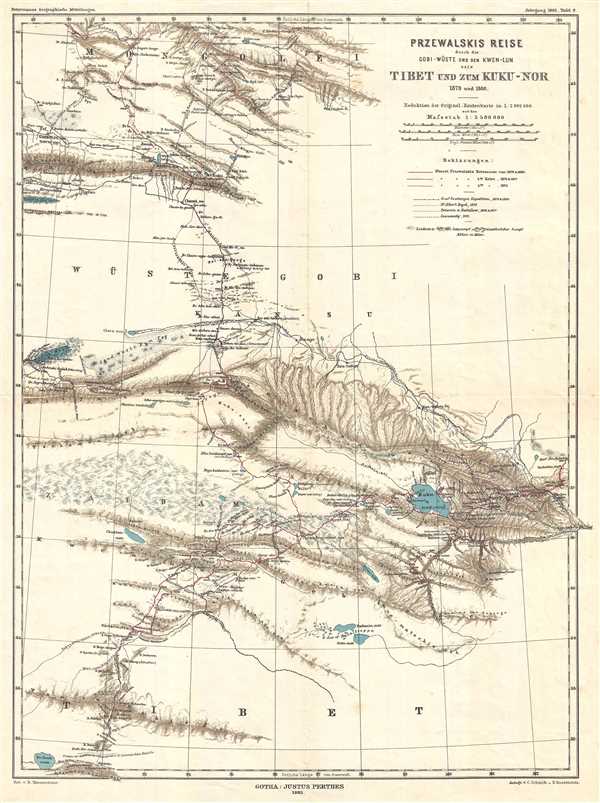
Przewalski's Reise durch die Gobi-Wüste und den Kwen-Lun nach Tibet und zum Kuku-Nor 1879 und 1880.
1883 (dated) 19 x 14 in (48.26 x 35.56 cm) 1 : 3500000
1883 (dated) 19 x 14 in (48.26 x 35.56 cm) 1 : 3500000
Description
This is an 1883 German map which was published in Petermanns Geographische Mitteilungen. The map depicts the journeys of Russian explorer Nikolay Mikhaylovich Przhevalsky from Mongolia into northern Tibet and parts of western China. Three different routes taken by Przewalski are illustrated on the map, as well as routes taken by four other expeditions between 1875 and 1880. Each of these expeditions traversed the Gobi Desert, which divides the map in two. Several different mountain ranges are depicted on the map, as well as lakes, rivers, salt marshes, deserts, and swamps. Qinghai Lake, the largest lake in China, is depicted on the map and labeled as 'Kuku-nor.' Lop Nur (Lob-Nor), a now largely dried-up salt lake in China, is illustrated along the left border. The map's title, translated into English, is 'Przewalski's journey through the Gobi Desert and the Kwen Lun to Tibet and the Kuku-Nor.'
Published for Petermanns Geographische Mitteilungen in Gotha in 1883.
Published for Petermanns Geographische Mitteilungen in Gotha in 1883.
Cartographer
Bruno Hassenstein (November 23, 1839 - August 27, 1902) was a German cartographer and was born in Ruhla, Thuringia. In 1854, Hassenstein began studying cartography and working under August Petermann in Gotha, founder of Petermanns Geographische Mitteilungen. Over the ensuing years, Hassenstein drew numerous maps for Petermanns Geographische Mitteilungen before relocating to Berlin in 1866 to work for another cartographer, including Karl Klaus von der Decken. He returned to Gotha two years later and works on maps for Henrich Theodor Menke's edition of Spurner's atlas of medieval history. He became editor of the cartography section of the Mittellungen in 1878 and worked on the Atlas von Japan, which was published in 1885. The University of Göttingen awarded him an honorary doctorate in 1878. More by this mapmaker...
Condition
Very good. Light foxing. Blank on verso.
References
OCLC 70263964.