1897 Garcia y Cubas Map of Puebla, Mexico
Puebla-garciacubas-1897$500.00
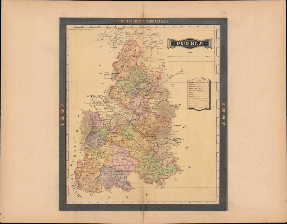

Title
Puebla.
1897 (dated) 15.75 x 18 in (40.005 x 45.72 cm) 1 : 900000
1897 (dated) 15.75 x 18 in (40.005 x 45.72 cm) 1 : 900000
Description
An exquisite chromolithographed map of the Mexican state of Puebla, published in 1897 for the Atlas Geográfico de los Estados Unidos Mexicanos.
A Closer Look
The state of Puebla is divided into districts, which are color-shaded for easy distinction. Cities, towns, haciendas, ranchos, mines, ruins, mountains, rivers, roads, and railways are labeled throughout. Latitude and longitude are provided along the edge of the map, with the latter being measured from Mexico City, which is only roughly 65 miles to the northwest of the state's capital city, Puebla.Historical Context
Like most of Mexico, the history of Puebla in the years preceding this map's publication was defined by modernization projects such as roads and railways, which are so numerous here that the individual company's lines are indicated differently to more easily distinguish them. Puebla played an important role as a gateway between Mexico City and Veracruz on the Gulf of Mexico to the east and to points further south. Moreover, rivers fed by runoff from the volcanic mountains Iztaccíhuatl and Popocatépetl were ideal for developing a textile industry in the cities of the state's western portion. At the same time, social inequality and political repression caused widespread unrest in Puebla towards the end of the Porfiriato (1876 - 1911), with the government's murder of opposition politician Aquiles Serdán in Puebla in 1910 being a catalyst for the Mexican Revolution.Publication History and Census
This map was published in Mexico City in 1897 by Vega y Cie. It is based on the 1886 work of Antonio García Cubas and was updated with additional border work for the 1897 issue of the Atlas Geográfico de los Estados Unidos Mexicanos. The atlas is represented in several institutional collections but is extremely scarce on the market. The individual maps, likewise, are scarce to the market.Cartographer
Antonio Garcia y Cubas (July 24, 1832 - February 9, 1912) was a Mexican cartographer, writer, engineer, and geographer active in Mexico City in the second half of the 19th and the early 20th centuries. He is considered Mexico's first great geographer. Garcia y Cubas was born in Mexico City. He was orphaned at birth and was raised by is aunt. When he turned 18, he enrolled in the Dirección General de Industria, a government sponsored technical school. There he studied engineering and geography, which he further pursued at the Colegio de San Gregorio, Colegio de Ingenieros. He graduated with honors in geography and from 1856, became a member of the Sociedad Mexicana de Geografía y Estadística. His geographical work earned him the Order of Guadalupe, a Mexican second empire honorific, directly from the Emperor Maximillian. He published several atlases, including his important Atlas Geográfico, Estadístico e Histórico de la República Mexicana, and multiple decorative chromolithograph Atlas Pintoresco e Históricos covering Mexico, Cuba, Spain, and elsewhere. Today his work is scarce and highly desirable. More by this mapmaker...
Source
García Cubas, Antonio, Atlas Geográfico de los Estados Unidos Mexicanos, (Mexico City: Vega) 1897.
Atlas Geográfico de los Estados Unidos Mexicanos is a grand-format folio atlas of Mexico. It is based largely upon the Atlas Geográfico y Estadístico de los Estados Unidos Mexicanos published in 1887 by Antonio García Cubas and Debray. The present atlas incorporates the same maps, but adds a dramatic silver and gold border, which obscures the 1886 García Cubas imprint. It was issued during Porfirio Díaz's third term as president of Mexico - a period marked by rapid expansion of infrastructure and industry, including railroads, mines, bridges, roads, and broad scale electrification and waterworks. The atlases title page in this 1897 edition, celebrates Diaz with a large portrait and dedication. We have identified at least two editions of this atlas, both bearing the 1897 date: one by Cadena y Cie, features a red title page, another by Vega y Cie, featuring a blue title page. All 1897 editions we have identified have the silver borders, but these seem to be overprinted to cover an earlier gold border, with unidentifiable text and dating behind. We have been unable to find any examples with only the gold border. The atlases in general are showpieces of Mexican lithography in the golden age of the Porfiriato.
Condition
Very good. Wide margins. Verso repair to a centerfold separation. Closed tear extending 1 inch into printed area professionally repaired on verso.
References
Rumsey 5758.026 (1886 Edition).