This item has been sold, but you can get on the Waitlist to be notified if another example becomes available, or purchase a digital scan.
1927 Bird's Eye View or Map of Puget Sound, Washington
PugetSoundCountry-navigationco-1927$175.00

Title
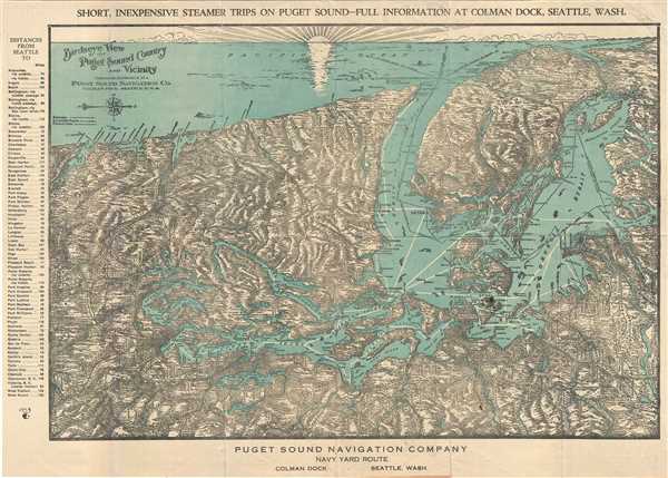
Birdseye View of Puget Sound Country and Vicinity.
1927 (undated) 15.5 x 21.5 in (39.37 x 54.61 cm)
1927 (undated) 15.5 x 21.5 in (39.37 x 54.61 cm)
Description
An unusual and attractive c.1927 bird’s eye view map of Puget Sound, Washington and vicinity issued by the Puget Sound Navigation Company. The view is oriented with north to the right and covers from the Columbia River northward as far as Queen Charlotte Sound in British Columbia, Canada, with a beautiful setting sun in the west. The map notes railroads, electric lines, roads, cities, towns, islands and topography. Ferry lines are also noted along the Juan de Fuca, Georgia and Malaspina straits. Several ships can be seen in the surrounding waters. An index noting the distances from Seattle to various locations is included along the left margin.
Verso features a regional map, and text giving an overview of the various available trips. This view was compiled expressly for the Puget Sound Navigation Co., to promote ‘short, inexpensive steamer trips on Puget Sound’.
Verso features a regional map, and text giving an overview of the various available trips. This view was compiled expressly for the Puget Sound Navigation Co., to promote ‘short, inexpensive steamer trips on Puget Sound’.
Condition
Very good. Minor wear along original fold lines. Minor spotting. Professionally flattened and backed with archival tissue.