
This item below is out of stock, but another example (left) is available. To view the available item, click "Details."
Details
1744 Bellin Map of Quebec City, Canada
1744 (undated) $350.00
1744 Bellin Map of Quebec City, Canada
Quebec-bellin-1744$175.00

Title
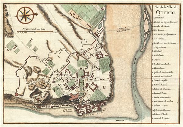
Plan de la Ville de Quebec.
1744 (undated) 8 x 11.5 in (20.32 x 29.21 cm) 4.902777778
1744 (undated) 8 x 11.5 in (20.32 x 29.21 cm) 4.902777778
Description
A scarce 1744 first state first edition of Bellin's important map of Quebec City, Canada. Oriented to the west, Bellin's map covers the fortified center of Quebec City at the conjunction of the St. Laurence River and the St. Charles estuary. The map illustrates various fortifications as well as some 24 individual buildings including churches, schools, batteries and government buildings. Some of the surrounding farmland is also illustrated. On the east side of the city the port and is identified.
When Bellin drew this map Quebec City was a major center for the French Colony of Quebec with its strategic location dominating trade on the vital St. Lawrence artery. After the French and Indian War control of Quebec fell to the British. British rule proved both beneficial and magnanimous to the predominantly French population.
Bellin prepared this map to illustrate Pierre François Xavier de Charlevoix's Histoire et description generale de la Nouvelle France, however most of its major updates are based upon the manuscripts compiled by Gaspard-Joseph Chaussegros de Lery, a French Canadian military engineer active throughout French America in the early 18th century. Charlevoix himself was a Jesuit missionary and traveler commissioned by the French Crown and the Duke of Orleans to reconnoiter French holdings in the Americas. The French had just lost control of the Hudson Bay and were actively in search of a profitable route to the Pacific, which many believed lay in the network of rivers and lakes to the west of the Great Lakes. Charlevoix thus had the secondary commission to 'inquire about the Western Sea, but [to] still give the impression of being no more than a traveler or missionary.'
Charlevoix's history proved exceptionally influential as one of the most comprehensive works on North America predating the French and Indian War. Copies of the Histoire et description generale were to be found in the libraries of many 18th century luminaries, including Voltaire, Franklin, and Jefferson. Jefferson especially admired Charlevoix work, calling it 'a particularly useful species of reading' that no doubt influenced his decision to pursue the historic 1802 Louisiana Purchase, possibly the most significant event in the post-colonial history of North America.
The present example is the first edition of Bellin's Quebec. It was later reissued in 1763 for Bellin's Petit Atlas Francois and in 1764 for his Petit Atlas Maritime.
Cartographer
Jacques-Nicolas Bellin (1703 - March 21, 1772) was one of the most important cartographers of the 18th century. With a career spanning some 50 years, Bellin is best understood as geographe de cabinet and transitional mapmaker spanning the gap between 18th and early-19th century cartographic styles. His long career as Hydrographer and Ingénieur Hydrographe at the French Dépôt des cartes et plans de la Marine resulted in hundreds of high quality nautical charts of practically everywhere in the world. A true child of the Enlightenment Era, Bellin's work focuses on function and accuracy tending in the process to be less decorative than the earlier 17th and 18th century cartographic work. Unlike many of his contemporaries, Bellin was always careful to cite his references and his scholarly corpus consists of over 1400 articles on geography prepared for Diderot's Encyclopedie. Bellin, despite his extraordinary success, may not have enjoyed his work, which is described as "long, unpleasant, and hard." In addition to numerous maps and charts published during his lifetime, many of Bellin's maps were updated (or not) and published posthumously. He was succeeded as Ingénieur Hydrographe by his student, also a prolific and influential cartographer, Rigobert Bonne. More by this mapmaker...
Source
Charlevoix, Pierre François Xavier de, Histoire et description generale de la Nouvelle France, avec le journal historique d'un voyage fait par ordre du roi dans l'Amérique septentrionnale, (Paris: Chez Rollin) 1744.
Condition
Very good. Narrow margins as issued. Blank on verso.
References
Rumsey 6903.017. Tooley Mapping America, p208-209. Library of Congress, Map Division, G3454.Q4 1755 .L4.