1776 Jefferys-Carver Map of Quebec with plans of Quebec City and Montreal
Quebec-sayerbennett-1776$1,600.00

Title
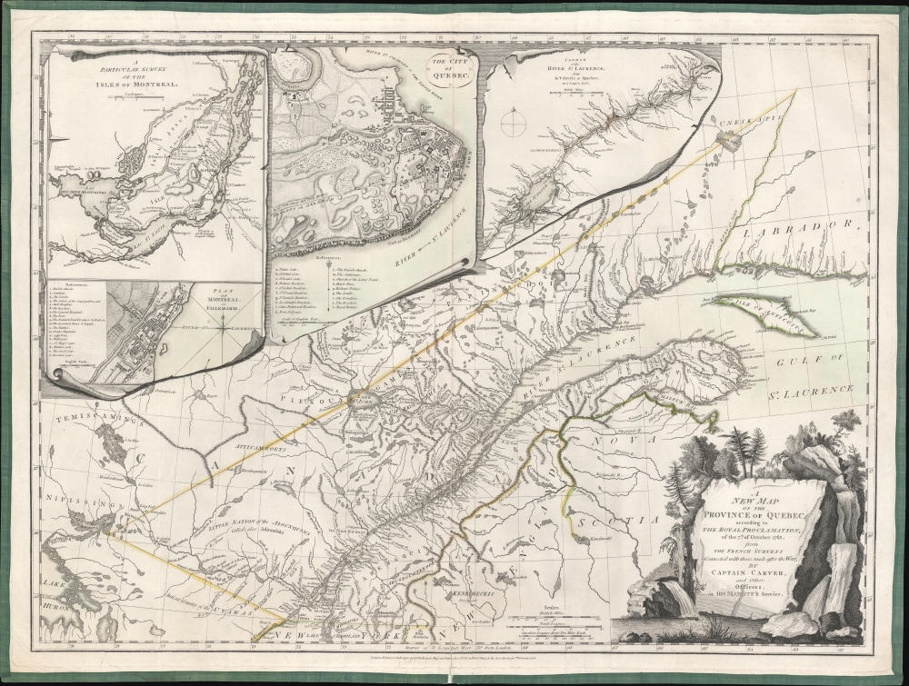
A New Map of the Province of Quebec, according to the Royal Proclamation of the 7th of October 1763 from the French Surveys Connected with those made after the War, by Captain Carver and Other Officers, in His Majesty's Service.
1776 (dated) 19.5 x 26 in (49.53 x 66.04 cm) 1 : 2200000
1776 (dated) 19.5 x 26 in (49.53 x 66.04 cm) 1 : 2200000
Description
This is the first state of the 1776 Sayer and Bennett Map of the newly-acquired Province of Quebec, with detail maps of the course of the St. Lawrence River, the Island of Montreal, and inset city plans of Montreal and Quebec City. This region passed from France to Great Britain following the signing of the Treaty of Paris in 1763 at the close of the French and Indian War (1754 - 1763). The map marks settlements, military outposts, major roads, and areas of Native American habitation with their tribal names noted. The two city plans include numbered and lettered keys indicating important structures and fortifications.
Carver's Surveys
Following the Treaty of Paris, the British surveyed the territory they now occupied in North America, formerly New France. Captain Jonathan Carver surveyed the region falling within the bounds of this map. As alluded to in the title, the map is based on unnamed French sources. Nonetheless, Carver was already familiar with the territory from his war service - he served with James Wolfe in the 1759 taking of Quebec.Bounds of the Survey
The borders of the Province are marked both with an engraved dotted line and with the application of yellow outline color. The straight lines and sharp angles of the border north of the Saint Lawrence River are easily discerned. Less obvious is the border considerably south of that river, hugging the mouth of Chaleur Bay and following a line of mountains running, with few breaks, to the White Mountains (here shown within New York) and skirting the northern end of Lake Champlain. The map thus suggests that, according to the Treaty of 1763, both shores of the Saint Lawrence River and its watershed fall within the bounds of Quebec.Evocatively Presented
The map is not only rich in detail, but it is also beautifully and entertainingly engraved. The title cartouche is framed with a rocky, forested waterfall scene; the title is engraved to appear chiseled into a rock face. Each of the four inset maps is presented in a trompe l'oeil , resembling separate sheets spread across the surface of the actual map.Publication History and Census
This map was engraved in 1776 for inclusion in Thomas Jefferys' American Atlas. Following Jefferys' death in 1771, Sayer and Bennett took over the production of the atlas. Further issues of the map were printed in 1788 and 1794. The map and the atlas are both well-represented in institutional collections.CartographerS
Robert Sayer (1725 - January 29, 1794) was an important English map publisher and engraver active from the mid to late 18th century. Sayer was born in Sunderland, England, in 1725. He may have clerked as a young man with the Bank of England, but this is unclear. His brother, James Sayer, married Mary Overton, daughter-in-law of John Overton and widow of Philip Overton. Sayer initially worked under Mary Overton, but by December of 1748 was managing the Overton enterprise and gradually took it over, transitioning the plates to his own name. When Thomas Jefferys went bankrupt in 1766, Sayer offered financial assistance to help him stay in business and, in this way, acquired rights to many of the important Jefferys map plates as well as his unpublished research. From about 1774, he began publishing with his apprentice, John Bennett (fl. 1770 - 1784), as Sayer and Bennett, but the partnership was not formalized until 1777. Bennett retired in 1784 following a mental collapse and the imprint reverted to Robert Sayer. From 1790, Sayer added Robert Laurie and James Whittle to his enterprise, renaming the firm Robert Sayer and Company. Ultimately, Laurie and Whittle partnered to take over his firm. Sayer retired to Bath, where, after a long illness, he died. During most of his career, Sayer was based at 53 Fleet Street, London. His work is particularly significant for its publication of many British maps relating to the American Revolutionary War. Unlike many map makers of his generation, Sayer was a good businessman and left a personal fortune and great estate to his son, James Sayer, who never worked in the publishing business. More by this mapmaker...
Jonathan Carver (April 13, 1710 - January 31, 1780) was an American explorer, cartographer, and writer active during the colonial period. He was born in Weymouth, Massachusetts and, During the French and Indian War (1754 - 1763), saw action with the famous 'Roger's Rangers'. During the war, he was able to learn mathematics and military surveying. He was elevated to captain and given charge of a regiment in 1761. When the war ended, Carver was determined to explore the new British territories ceded by the Treaty of Paris. In 1766, he was hired by the leader of Robert's Rangers, frontiersman and Royal Governor Robert Rogers (1731 - 1795), to join an expedition in search of an interior water route between the Mississippi and the Pacific. With Rogers, he explored parts of the Upper Mississippi basin in modern-day Wisconsin, Minnesota, and Iowa. In 1769, the expedition ended with significant new cartography. Carver believed he may have found a water route to the Pacific - likely the Missouri. In the meantime, Rogers, his patron, was arrested and court-martialed for treason. Carver was caught in the fallout from Rogers' court-martial, and his discoveries were never formally recognized. Seeking redress from the crown, Carver traveled to England, where his requests were heard, though he never received his hoped-for reward for discovering the Northwest Passage. Carver's cartographic information was passed to Robert Sayer, who incorporated some of it into his maps. While in England, Carver also completed his memoirs, published in 1778 as Travels through the Interior Parts of North America, in the Years 1766, 1767 and 1768. He died one year later in 1780. In 1804, several of Carver's descendants portioned the U.S. Congress for ownership of an extensive land grant in Wisconsin Territory - the Carver Grant - apparently ceded to him by the Sioux in exchange for 'many gifts'. The U.S. Congress denied the (probably) fraudulent claims, and the grant was voided despite appearing on maps well into the 1840s. Learn More...
Source
Rumsey 0346.021 (1776 edition). OCLC 5407771. Tooley, R. V. The Mapping of America, #73 (a). Goss, J. The Mapping of North America, #61. Phillips, P. A List of Maps of America, p. 729. Kershaw, Kenneth A., Early Printed Maps of Canada, vol. 4, #1005.
Thomas Jefferys' The American Atlas is among the most important atlases of American issued during and after the American Revolutionary War (1775 - 1783). Burden calls it 'arguably the first American 'state' atlas' and Ristow writes, it is a '… major cartographic reference work it was very likely consulted by American, English and French civilian administrators and military officers during the Revolution…' It was first published in 1775, with updates following in 1776, 1778, 1782, 1794, and 1800. All editions are notably postdate Jefferys himself, who died in 1771. The application of his name to the The American Atlas is mostly an honorific - though most of the constituent maps can be traced to Jefferys' work. After Jefferys' death, his map plates were acquired by his partner, printseller Robert Sayer. By the mid-1770s Sayer had taken on John Bennett as a partner. Together, they compiled and updated many of Jefferys' map, published as the to capitalize on interest in America associated with the Revolution. Maps from the The American Atlas exhbit is considerable date variation, with some featuring dates later than the title page, suggesting that many were updated by owners in subsequent years, and/or that the title page was reused for latter editions.
Condition
Good. Separation at bottom centerfold, reinforced. Some buckling of paper from original linen border. Original outline color.
References
Rumsey 0346.021 (1776 edition). OCLC 5407771. Tooley, R. V. The Mapping of America, #73 (a). Goss, J. The Mapping of North America, #61. Phillips, P. A List of Maps of America, p. 729. Kershaw, Kenneth A., Early Printed Maps of Canada, vol. 4, #1005.