This item has been sold, but you can get on the Waitlist to be notified if another example becomes available, or purchase a digital scan.
1898 Toronto Lithographing View and Map of the Quebec and St. John Railway
QuebecLakeStJohn-torontolithographing-1898$325.00


Title
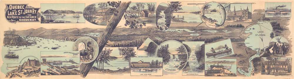
Quebec and Lake St. John Railway. The New Route to the Far Famed Saguenay.
1898 (dated) 8.25 x 30.25 in (20.955 x 76.835 cm)
1898 (dated) 8.25 x 30.25 in (20.955 x 76.835 cm)
Description
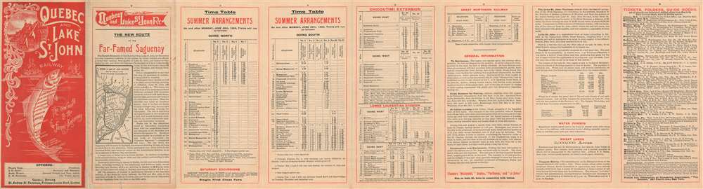
This is an 1898 Toronto Lithographing Company View and Map of the Quebec and Lake St. John Railway in Canada. Running from Quebec City to Roberval on Lake St. John, the 'Quebec and Lake St. John Railway' was the first railway constructed on the north side of the St. Lawrence River. A pictorial tourist view occupies the front of this fold-out, illustrating Quebec on the left and Lake St. John on the right. Towns, clubs, game clubs, and lakes dot the landscape between the railroad's two termini. Enticing views, meant to encourage tourism line the top and bottom and detail the Chateau Frontenac in Quebec, club houses and fisherman's huts, picturesque waterfalls and luxurious hotels. On the verso, aside from the practical information which includes time tables and extensions, is a clever railway map in the form of a fish, meant to further reinforce the region's wealth of outdoor activity.
The Quebec and Lake St. John Railway
The 'Quebec and Lake St. John Railway' was founded in 1869 as the 'Quebec and Gosford Railway'. The railway's name was officially changed to the 'Quebec and Lake St-John Railway' on December 24, 1870 and originally connected Quebec with the canton of Gosford. The railway did not receive authorization to extend to Lake St. John until 1875 and construction began in 1880. The railroad reached Roberval on Lake St. John in 1888. The 'Quebec and St. John Railwa'y was bought by the 'Great Northern Railway of Canada' in November 1906.Publication History and Census
This map was created and printed by the Toronto Lithographing Company in 1898. Two examples are cataloged in OCLC and are part of the institutional collections at McGill University and the Library and Archives Canada/Bibliothèque et Archives Canada.Cartographer
The Toronto Lithographing Company (1878 - 1909) was regarded as the largest and most advanced lithography firm in Canada. The company printed maps, books, printed envelopes, and other materials, and, in 1898, began printing postcards. They are also known for the celebrated political posters from the 1891 election. The Toronto Lithographing Company changed its name to Stone Ltd. in 1909, and merged with their main rival in Toronto, Rolph, Smith, and Company, in 1917 to form Rolf-Clark-Stone. More by this mapmaker...
Condition
Very good. Exhibits light wear along original fold lines. Verso repairs to fold separations.
References
OCLC 1007293742.