1931 American Geographical Map of the Queen Maud Mountains, Antarctica
QueenMaudMtns-americangeo-1931$450.00

Title
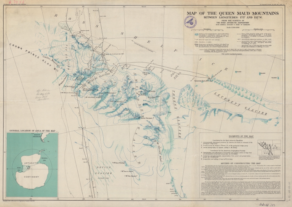
Map of the Queen Maud Mountains Between Longitudes 175° and 135° W. From the Surveys of The Byrd Antarctic Expedition.
1931 (dated) 20 x 28.5 in (50.8 x 72.39 cm) 1 : 500000
1931 (dated) 20 x 28.5 in (50.8 x 72.39 cm) 1 : 500000
Description
This is a 1931 American Geographical Society map of the Queen Maud Mountains, Antarctica. Named by Roald Amundsen after the Norwegian queen Maud of Wales, the Queen Maud Mountains are a group of mountains, ranges, and subordinate features of the Transantarctic Mountains. They are situated between the Beardmore and Reedy Glaciers and run from the Ross Ice Shelf to the Antarctic Plateau.
A Closer Look
Compiled using information contributed by the Byrd Expedition and the American Geographical Society, the map traces the three expeditions undertaken by the Byrd party (November - December 1929) as well as the route of Amundsen's South Pole Expedition. Numerous positions along the Byrd route were determined astronomically, allowing for a degree of precision. Mountain peaks, glaciers, and other features are noted.Richard Byrd's First Antarctic Expedition
Byrd's first Antarctic expedition took place between 1928 and 1930. The team erected a base camp which they named 'Little America' on the Ross Ice Shelf and conducted scientific expeditions by snowmobile, dog sled, snowshoe, and airplane. The team completed geological surveys and photographic expeditions and remained in constant radio contact with the rest of the world. It was during this expedition that Byrd, along with three others, flew to the South Pole and back. Following the flight, Congress promoted Byrd to the rank of rear admiral, one of only three people to be promoted to that rank in the U.S. Navy without having first held the rank of captain. The expedition survived two Antarctic winters and returned to North America on June 18, 1930.A Disturbing Library Stamp
A library stamp from the Geographishes Institut der Universitat Berlin appears just to the left of the title in the legend above the scale. While library stamps are unremarkable (libraries regularly deaccession materials), the present stamp bears the insignia of the Nazi Party, suggesting it was added to the University collection under the Nazi regime.Publication History and Census
This map was created and published by the American Geographical Society to accompany an article written by Laurence M. Gould (who accompanied Byrd on the expedition) that was published in the April 1931 edition of The Geographical Review. This map is well represented in institutional collections; the present example bears a Nazi-era stamp for the Geographisches Institut der Universitat Berlin.Cartographer
The American Geographical Society (AGS) (1851 - Present) is an organization founded in in New York City 1851 by thirty-one New Yorkers. Organized to search for the lost Franklin Expedition, the search for Franklin proved unsuccessful. However, the AGS remained, and members played roles in surveying for the transcontinental railway and supported continued exploration efforts. Its main areas of focus were the Arctic, Antarctic, and Latin America and any exploration it sponsored was required to produce tangible scientific results. Today, after nearly 175 years, the AGS is still in operation and focuses its energy on promoting geographical education. More by this mapmaker...
Source
Gould. L.M., 'Some Geographical Results of the Byrd Antarctic Expedition', The Geographical Review, Vol. XXI No. 2, (New York) Apr. 1931.
Condition
Good. Backed on archival tissue for stability. Closed tears extending two-and-one-half (2.5) and one-and-one-quarter inches from top margin professionally repaired. Bears Nazi library stamp.
References
OCLC 6135564.