This item has been sold, but you can get on the Waitlist to be notified if another example becomes available, or purchase a digital scan.
1930s Geographia Map or Plan of Queens, New York
Queens-gross-1930s$137.50

Title
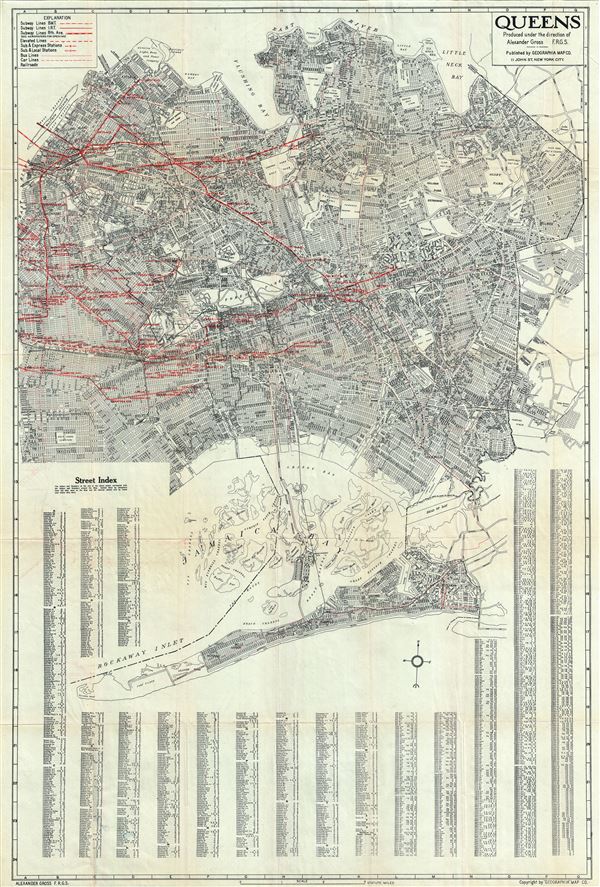
Queens.
1930s (undated) 37 x 24 in (93.98 x 60.96 cm) 1 : 35000
1930s (undated) 37 x 24 in (93.98 x 60.96 cm) 1 : 35000
Description
This is an impressive 1930s map of or plan of Queens, New York, issued by Alexander Gross and published by the Geographia Map Company. The map covers the easternmost of the five boroughs of New York City from Rockaway Point (Breezy Point) northward to the East River and Flushing Bay, including Jamaica Bay. Roosevelt Island (Welfare Island) is also included. The map is exceptionally detailed and identifies streets, cemeteries, parks, rivers, bays, marsh land, golf courses and a host of other topographical features. Transportation lines including subway lines, bus routes, and subway stations are identified in red. The map notes the Triborough Bridge (JFK Bridge) still under construction, suggesting that this map was issued in the early 1930s, after construction on the bridge began in 1929 and before completion in 1936. The map also notes identifies Flushing Airport, a now decommissioned airfield. The Jamaica Sea Airport is also identified. The Jamaica Sea Airport was an airstrip in Idlewild that opened in 1927, before the existence of JFK Airport. A street index is included below map proper. This map was published by the Geographia Map Company, New York, under the direction of Alexander Gross, F.R.G.S.
Cartographer
Geographia, Ltd. (1911 - 1985) was a London-based cartographic publishing firm. The company was founded by Alexander Gross (1879 - 1958), a Hungarian immigrant to the United Kingdom. Geographia Ltd. is best known for its folding pocket maps and globes. Many of his maps were drawn by a mysterious 'Mr. Fountain', of whom we have been able to discover little. Gross ran into financial problems around 1940, likely associated with World War II, and relocated to offices in New York at 11 John Street. There, he issued a large corpus of U.S.-focused maps and city plans. By the 1940s, the branch in the United States had been renamed the Geographia Map Company and experienced rapid growth. By the 1950s, Geographia had published maps of dozens of cities across the United States. In 1987, the British branch was bought out by Harper Collins and continues to produce maps under the Collins Bartholomew imprint. Rand McNally bought the New York-based Geographia Map Company in the late 1980s. However, its original owners repurchased the Geographia Map Company a few years later and still operate the company in Hackensack, New Jersey. Gross's daughter, Phyllis Isobella Gross / Pearsall (1906 - 1996), founded the Geographers' A-Z Map Company in London, the largest independent map publisher in the United Kingdom. In the UK, their offices were originally at 33 Strand, where they published as 'Geographia Designing and Publishing Company Ltd.'. Later, by 1933, they had relocated to 55 Fleet Street, where they remained until at least 1937. By 1942, they relocated to 167 Fleet Street, followed by 114 Fleet Street by 1964. It is of note that many of the Geographia Ltd. maps feature a peculiar dating system wherein the letters in the world CUMBERLAND correspond to the numbers 1234567890, such that a date is rendered by substitution, so A.MU would break out like this A = 8, M = 3, U = 2, so 8.32 or, August 1932. Or, MM.YY e.g. E.MC = 5.31 = May 1931. More by this mapmaker...
Condition
Very good. Minor wear along original fold lines. Professionally flattened and backed with archival tissue. Minor red markings over Jamaica Bay.