This item has been sold, but you can get on the Waitlist to be notified if another example becomes available, or purchase a digital scan.
1913 Brooklyn Eagle / Williams Map of Queens, Manhattan, Bronx, Long Island
QueensManhattanLI-brooklyndailyeagle-1913$300.00


Title
Map of Borough of Queens / Map of Nassau and Suffolk Counties / Map of Boroughs of Manhattan and Bronx.
1913 (dated) 33 x 26 in (83.82 x 66.04 cm) 1 : 40000
1913 (dated) 33 x 26 in (83.82 x 66.04 cm) 1 : 40000
Description
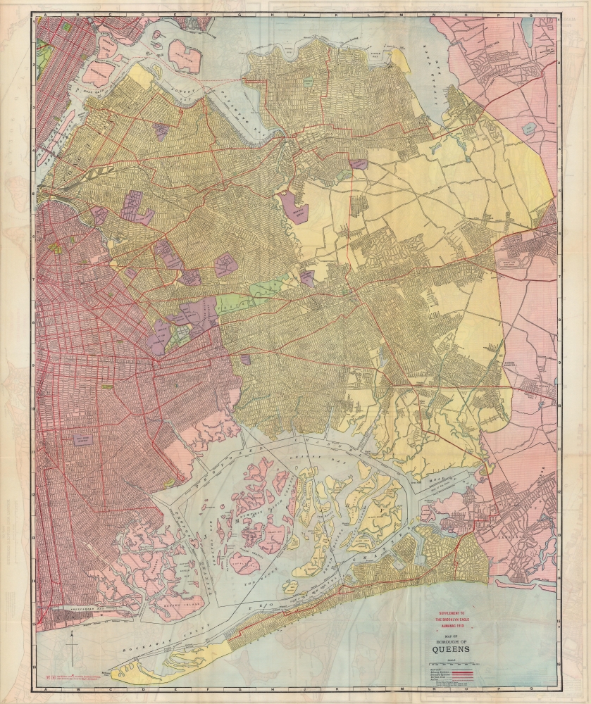
A rare, highly-detailed, and curious 1913 map of the Borough of Queens, with maps of Manhattan, the Bronx, and Long Island on the verso. The map reveals Queens during its most explosive period of growth - as such, it is highly speculative, despite a misleading level of seemingly precise detail based upon prospective (but often unrealized) development schemes.
Entire neighborhoods are imagined based on short-lived names or proposed property developments, such as Nassau Heights (Maspeth) and Louona Park (Corona). Many of the named streets would adopt a numeric system of streets and avenues by the end of the 1920s, while others adopted new names (an important example, 'Jackson Ave.' became Northern Ave.).
At the same time, the Long Island Railroad became fully electrified in Queens, constructed the impressive Sunnyside Yards complex (seen at left towards top), and extended to the recently-completed Pennsylvania Station ('old Penn Station'). The Hell's Gate Bridge, seen here as under construction, allowed for the establishment of the New York Connecting Railroad, linking Long Island directly with the Bronx and points north. The new ease of transportation, the availability of land in Queens, and the rapidly growing population of New York City pushed the population of Queens from 153,000 people in 1900 to over 1 million by 1930.
A Closer Look
Railroad, subway, streetcar, and ferry lines are indicated throughout. Urban development in Queens was so rapid at this point that much of the cartography here is speculative, based on assumptions of future growth, explaining areas where the city grid appears to overlap with waterways or where new roads cut through existing neighborhoods. In reality, the pre-existing towns that composed the borough (Long Island City, Jamaica, Newtown, Flushing) were still recognizable in its geography. For instance, Jackson Heights and East Elmhurst (North Beach and Trains Meadow here) were undeveloped at this point, and much of the beachfront of the latter was devoted to the North Beach Airport (LaGuardia Airport) rather than residential use.Entire neighborhoods are imagined based on short-lived names or proposed property developments, such as Nassau Heights (Maspeth) and Louona Park (Corona). Many of the named streets would adopt a numeric system of streets and avenues by the end of the 1920s, while others adopted new names (an important example, 'Jackson Ave.' became Northern Ave.).
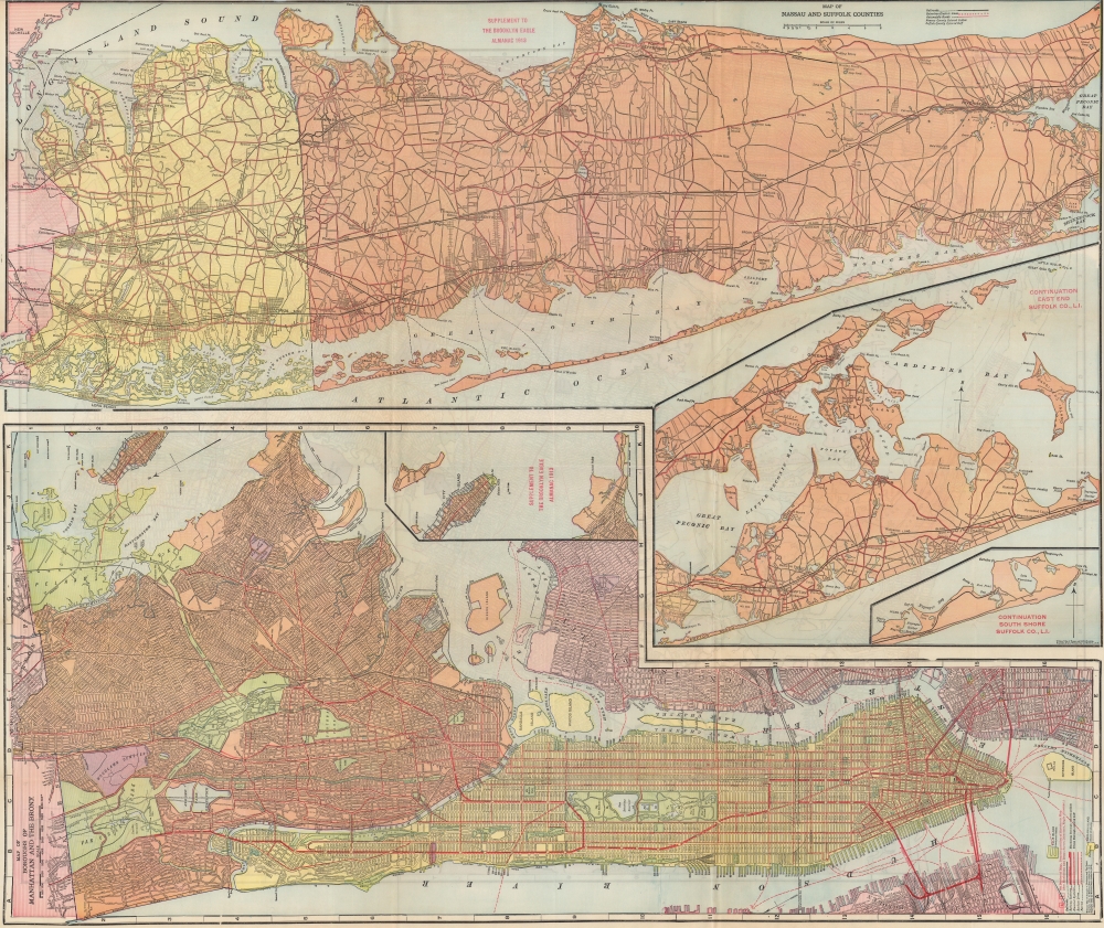
Verso Content
The verso is roughly divided in half, with the top including a map of Long Island (Nassau and Suffolk Counties), highlighting the importance of the Long Island Railroad and suburban electric lines, but also significantly noting the Long Island Parkway (Vanderbilt Parkway), often considered the first American road designed for automobile-only use. The bottom half includes a map of Manhattan and the Bronx oriented towards the east, with north at left. The Bronx map is largely speculative like the Queens map on the recto; as at this time, there was limited development north of the Bronx River.Historical Context
This map depicts Queens, which had only been unified and incorporated into New York City as a Borough at the end of the 19th century, in the early stage of a major expansion. The Queensborough Bridge opened in 1909 greatly easing transit between Manhattan and Queens, though ferry services continued, as can be seen here. The elevated IRT Second Avenue Line soon offered service across the new bridge. In the years immediately following this map's publication, the Steinway Tunnel opened another connection between Manhattan and Queens, permitting the construction of the IRT Flushing Line, today's 7 train. With urban planning operating at peak efficiency, housing for workers building the line to Flushing was constructed along the path of the train.At the same time, the Long Island Railroad became fully electrified in Queens, constructed the impressive Sunnyside Yards complex (seen at left towards top), and extended to the recently-completed Pennsylvania Station ('old Penn Station'). The Hell's Gate Bridge, seen here as under construction, allowed for the establishment of the New York Connecting Railroad, linking Long Island directly with the Bronx and points north. The new ease of transportation, the availability of land in Queens, and the rapidly growing population of New York City pushed the population of Queens from 153,000 people in 1900 to over 1 million by 1930.
Publication History and Census
This map was produced by the Williams Map and Guide Co. for the 1913 Supplement to the Brooklyn Eagle Almanac. Neither the present map nor the 1913 almanac is cataloged in the OCLC, though other editions of the map and almanac do appear.Cartographer
Brooklyn Eagle (1841 – 1955; 1960 – 1963) was a daily newspaper published in Brooklyn that at one point was the afternoon paper with the largest circulation in the U.S. Its editors included Walt Whitman and the paper was closely connected with the Democratic Party in New York. It closed during a long strike in 1955 and was briefly revived in the early 1960s before folding again. A much smaller-scale newspaper reviving the name Brooklyn Eagle has been in publication since 1996. More by this mapmaker...
Condition
Very good. Some toning and wear along old fold lines.