This item has been sold, but you can get on the Waitlist to be notified if another example becomes available, or purchase a digital scan.
1924 Cram Radio Map of the United States and Canada
RadioMap-cram-1924$275.00

Title
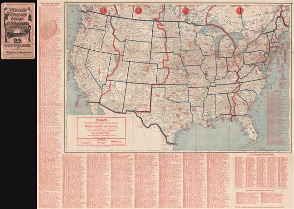
Cram's Detailed Radio Map of Broadcasting Stations of the United States and Canada.
1924 (dated) 27.5 x 33.5 in (69.85 x 85.09 cm) 1 : 6336000
1924 (dated) 27.5 x 33.5 in (69.85 x 85.09 cm) 1 : 6336000
Description
This a scarce 1924 pre-network radio station map of the United States and parts of Canada issued by The George F. Cram Company. The map depicts the whole of the United States and southern Canada divided according to time zones. Over a thousand radio stations are identified throughout the map along with their associated call numbers. The first radio network broadcast, by NBC (National Broadcasting System), took place on November 15, 1926, two years after this map was issued.
There are several editions of this map. We have not been able to positively identify a first edition, and the present is a 1923-1924 'Revised' edition. Reflecting the rapid development of the American radio system, editions differ greatly in content and form.
Radio Station Call Letters
The map illustrates the radio station naming system. Originally intended for the Telegraph Network, an international conference in 1912 on 'RadioTelegraphs' or 'Telegraphs' assigned various letter codes to different countries. American was assigned W (east of the Mississippi), K (West of the Mississippi), N (Government and Military), and A (Government and Military). Canada was assigned C, and Mexico X.There are several editions of this map. We have not been able to positively identify a first edition, and the present is a 1923-1924 'Revised' edition. Reflecting the rapid development of the American radio system, editions differ greatly in content and form.
Cartographer
George Franklin Cram (May 20, 1842 - 1928) was an American map publisher active in the late 19th and early 20th centuries. During the American Civil War, Cram served as a staff cartographer for the Union General Ulysses S. Grant and participated in Sherman's 'March to the Sea'. In 1867, after being discharged from the army, George Cram moved to Chicago, where he founded 'Blanchard and Cram' with his uncle Rufus Blanchard Evanston. Blanchard and Cram was a supply house for the book trade - though they also published a few maps during this period. This short lived business was destroyed in the 1871 by the Great Chicago Fire. After the fire, recognizing a business opportunity in the burgeoning railroad industry, Cram reinvented himself as cartographic publisher, opening the Cram Map Depot. Like fellow Chicago publisher Rand McNally, Cram took advantage of the economical wax engraving processes to inexpensively produce maps in vast quantities. His signature publication, the Unrivaled Atlas of the World became the world's best-selling atlas and was published from the 1880s to 1952. On retiring in 1921, Cram sold his company to Edward A. Peterson of the National Map Company (Scarborough Company). Peterson moved the company to Indianapolis where, following Cram's death, he rebranded the National Map Company as the George F. Cram Company, surely thinking to capitalize on the established identity of the firm. In 1930 he entered the globe market for which the firm was best known from the mid-20th century. In time the firm expanded globally passing becoming a major concern. Loren B. Douthit became company president in 1968 and the Douthit family ran the business until Herff Jones, Inc., bought the company in 2005. More by this mapmaker...
Condition
Good. Removed from binder (included) and backed on archival tissue. Some minor repaired loss at several fold intersections. Minor wear on original fold lines.
References
OCLC 885257093.