
1615 Henri de Beauvau Bird's Eye View of Ragusa (Dubrovnik, Croatia)

This item has been sold.
Raguse.
Early Bird's-Eye View of Dubrovnik.
- Digital Map Information
- Suitable for large format printing
- File Size: 3.07 MB
- File Type: ZIP / TIFF
- ICC color profile embedded
- Delivered instantly via download link
Early Bird's-Eye View of Dubrovnik.
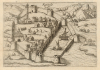
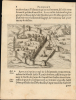
This is a 1615 copperplate view map of Ragusa (Dubrovnik, Croatia), viewed as if from a high point, highlighting the city's harbor and defenses. It was issued for the first illustrated edition of Henri de Beauvau's travel narrative.A Closer Look
The image takes the form of a bird's-eye view, highlighting the city's harbor and impressive defenses. The city's medieval walls, church steeples, and living quarters are illustrated. Soldiers can be seen drilling within the walls. The walls are also illustrated protecting the harbor, with a chain across its mouth. Towns, forests, and mountains are pictorially represented in the surrounding countryside.Ragusa
Medieval Ragusa, now Dubrovnik, was a Venetian territory and a vital link in the spice trade. When the Portuguese established a sea route around Africa to the Spice Islands, the overland spice trade dried up. Ragusa managed to maintain its influence by carefully balancing the interests of Venice with those of the Ottoman Empire, and their merchant fleet could travel freely in the territories of both powers. In 1667, Ragusa suffered a catastrophic earthquake, which took as many as 5,000 lives and flattened most of the structures visible here. Dubrovnik's famous city walls survived the earthquake and thus are more recognizable.The Source
This engraving appeared in the 1615 illustrated edition of Henri de Beauveau's 1608 Relation journalière du voyage du Levant, which described his experience escorting the 1604-1605 embassy to Istanbul of Jean de Gontaut-Biron, Baron de Salignac. Beauvau's journal, from its first printing, provided an eager French audience a welcome firsthand description of the eastern parts of the Mediterranean. It was not until the 1615 second edition, however, that city views and maps were included in the work. These were mostly derived from earlier works, mainly from the 1574 Isolario of Camocio and the 1598 Rosaccio Viaggio da Venetia a Constantinopoli, which appears to have been the basis for the present work (a much more decorative and accomplished engraving than its precursor).Publication History and Census
This map was executed in 1615 by an anonymous engraver for inclusion in the Jacob Garnich edition of Beauvau's Relation journalière du voyage du Levant. The Relation is well represented in institutional collections, but the separate image is not listed in OCLC, and we see none in dealers' catalogs or auction records.Cartographer
Henri de Beauvau (c. 1550 - 1630) was a French soldier, diplomat, and author. He is known to have fought the Turks in Hungary in the army of Emperor Rudolph III, and later in the service of the elector of Bavaria. He is recalled primarily for his account of his 1604 - 1605 voyage to Istanbul, escorting Jean de Gontaut-Biron, Baron de Salignac, the French ambassador to the Ottoman Empire. The travelogue amounted to a firsthand description of the ports of the Eastern Mediterranean. Its first, 1608 edition was text-only; the Nancy edition of 1615 contained an array of copperplate views: attractively-engraved, but mainly derived from images in Camocio's 1574 Isolario. Further Details...
Source
Beauvau, Henri de, Relation journalière du voyage du Levant (Nancy: Garnich) 1615.
Condition
Excellent. Tiny mended wormholes outside printed image, else fine. Image size includes text: view without text measures 4.25 x 6 inches.