This item has been sold, but you can get on the Waitlist to be notified if another example becomes available, or purchase a digital scan.
1934 Showa 9 Panoramaic Map of Japan, Korea, Taiwan and Manchuria
Railguide2-japan-1934$150.00

Title
Dai Nippon Teikoku.
1934 or Showa 9 10 x 93 in (25.4 x 236.22 cm)
1934 or Showa 9 10 x 93 in (25.4 x 236.22 cm)
Description
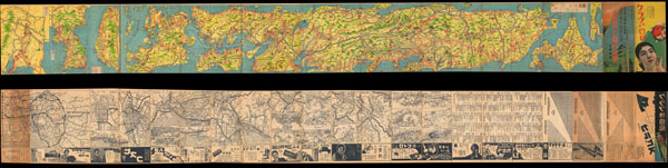
An extremely attractive 1934 or Showa 9 panoramic map of Dai Nippon Teikoku or the Japanese Empire. This uncommon type of map evolved out of traditional Japanese view-style cartography and began to appear in Japan, Taiwan, and Korea in the early 20th century. Generally speaking such maps coincided with the development of railroad lines throughout the once vast Dai Nippon Teikoku or Japanese Empire. It is a distinctive style full of artistic flourish that at the same time performs a practical function. This particular example is both relatively early and exceptionally beautiful. It was printed via a multi-color lithographic process with delicately shaded tones and a easily comprehensible intuitive design. Essentially a transportation map, it shows the major and minor rail lines throughout the empire, including the territories of Taiwan, Korea and Manchuria. Verso features advertisements, photos, train time tables and a series of smaller views and city plans. All text in Japanese.
Condition
Very good. Original folds. Some edge wear. Else clean. Photo above depicts both recto and verso of map.