1899 Graham Map of the Ralston Divide, Placer County, California Gold Country
RalstonDivide-graham-1899$1,400.00

Title
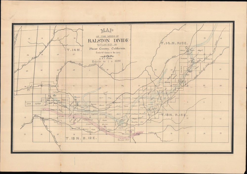
Map of the Mines of Ralston Divide situated in in Placer County, California.
1899 (undated) 16 x 26.75 in (40.64 x 67.945 cm) 1 : 32180
1899 (undated) 16 x 26.75 in (40.64 x 67.945 cm) 1 : 32180
Description
An unrecorded 1899 survey and plat map of the Ralston Divide in Placer County, California, prepared by William S. Graham, the County Surveyor. This area was ground zero for the gold rush in the middle of the 19th century; by century's end, the easily accessible gold was long gone, but other valuable minerals remained, especially quartz, which was the impetus for the present map.
After the gradual decline of gold mining in this area over the second half of the 19th century, it experienced something of a 'second wind' with miners seeking other minerals, especially quartz. When these mines also ran their course, small ghost towns and abandoned mines were left behind, making the transition to semi-protected National Forest between 1905 and 1910 relatively easy.
A Closer Look
Covering an area west of Lake Tahoe and east of Auburn near the Ralston Ridge and Oxbow Reservoir (not to be confused with another of the same name in Oregon), this map includes land that today is on the border of the Tahoe and Eldorado National Forests. It is overlaid with a survey grid, with individual properties labelled - in some cases with nicknames and in others with the owner's name - along with rivers, creeks, ditches, 'cañons,' mines, and scattered houses and cabins. The blue and red lines prominently running through the map most likely indicate mineral deposits. Additional handwritten notes appear periodically, especially at bottom - such as 'Corcoran's Mine,' 'big quartz load.' Scale is given in both English and French; this may reflect a large number of French or Québecois miners, which is also suggested by the nicknames of some of the properties (Paris, Lyon, Rigaud).After the gradual decline of gold mining in this area over the second half of the 19th century, it experienced something of a 'second wind' with miners seeking other minerals, especially quartz. When these mines also ran their course, small ghost towns and abandoned mines were left behind, making the transition to semi-protected National Forest between 1905 and 1910 relatively easy.
Publication History and Census
This map was drawn by William Sutphen Graham, the surveyor of Placer County. It is undated, but an article in the November 4, 1899, issue of the Placer Herald contains a short notice titled 'A Fine Map':While in the office of the County Surveyor, W. S. Graham, the other day, the HERALD's reporter saw a 'blue print' of the Ralston divide map drawn by Mr. Graham. The map represents a 'contact' of forty miles, although to cover this distance a linear survey of 200 miles had to be made. The map is a credit to Mr. Graham's skill as a surveyor and draughtsman.Aside from this article, no other reference of the map can be found. It is not known to exist in any institutional collections, nor have any history on the market.
Cartographer
William Sutphen Graham (fl. c. 1890 - 1900) was the county surveyor of Placer County, California at the end of the 19th century. Born in Illinois, he is recorded as having resided in Auburn, the seat of Placer County, from 1886, being listed in census records and city directories as either a surveyor or civil engineer. He appears to have stopped holding the position of County Surveyor soon after the turn of the century, with no information available about his subsequent life and works. More by this mapmaker...
Condition
Good. Light wear along original folds. Small blue stain on the bottom appears to be made while watercoloring the piece. Small tear professionally repaired on edge.