This item has been sold, but you can get on the Waitlist to be notified if another example becomes available, or purchase a digital scan.
1769 Ratzer 'Ratzen Plan' or Map of New York City
RatzenPlanNewYork-ratzer-1769$12,500.00


Title
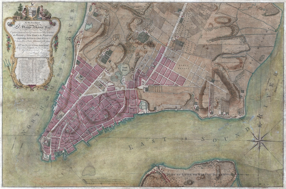
To His Excellency Sr. Henry Moore, Bart. Captain General and Governour in Chief in and over the Province of New York and the Territories depending thereon in America Chancellor and Vice admiral of the same, This Plan of the City of New York, is most HUmbly INscribed, by His Excellency's Most Obedient Servant, Bernd. Ratzen.
1769 (dated) 23.75 x 35.5 in (60.325 x 90.17 cm) 1 : 5000
1769 (dated) 23.75 x 35.5 in (60.325 x 90.17 cm) 1 : 5000
Description
Known as the 'Ratzen Plan,' this is one of the most important, beautiful, and iconic colonial era maps of New York City, offered here in its rare first state. It is the among the most important pre-Revolutionary War maps of Manhattan.
With effigies of British nobleman and military officers burning in the streets, General Thomas Gage, then commander of British forces in North America, feared open rebellion. In preparation, he ordered Lieutenant John Montresor to immediately compile a plan of Manhattan. Montresor hastily completed the plan in just two months, which he submitted to Gage on February 8, of 1766. The plan suffered from the incommodious circumstances under which it was compiled with few streets named, their distances and orientations imprecise, and little overall detail with few structures noted. Shortly after the map was completed, Montresor returned to England on a leave of absence, taking his map with him for printing.
In the same year Parliament passed the 1765 Quartering Act, which required New Yorkers to provide housing to British Regulars. While the exceedingly unpopular act was never fully enforced, some 1500 British soldiers, among them the surveyor Bernard (Bernhard) Ratzer, descended upon New York. Ratzer, who had already established a reputation as a fine draughtsman and surveyor during the war, was called upon by Royal Governor of New York, Sir Henry Moore, to refine and complete Montresor's survey. Ratzer worked on the survey throughout the remainder of 1766 and 1767, sending it to England for engraving and publication in the same year. Ratzer continued to refine his survey, producing another larger map of New York City in 1770 and surveying the New York - New Jersey boundary.
In England, Ratzer's plan was engraved by Thomas Kitchin, one of the foremost engravers then active in London. Kitchin masterfully executed Ratzer's manuscript draught in print form, producing one of the finest maps of any American city then seen. He did however make one significant error, misspelling Ratzer's name as 'Ratzen,' thus forever dubbing this the 'Ratzen Plan.' The 'Ratzen Plan' formed the core of Ratzer's larger map of New York, the 1770 'Ratzer Map,' so named for Kitchin's correction of this error on the earlier work. That map, in turn, is the core of an enormous unpublished manuscript, surviving in the British Library, illustrating all of New York Harbor and the surrounding lands – giving evidence to the full extent of Ratzer's remarkable survey.
Augustyn and Cohen in Manhattan in Maps comment that
A Closer Look
This map was surveyed in 1767 by Bernard Ratzer, a lieutenant in the 'Royal American' regiment at the behest of Sir George Moore, governor of New York, who is sited in the cartouche. The map, which covers the southern part of Manhattan to about modern-day 14th street, is a revision and expansion upon the flawed John Montresor plan of 1767. Gloria Deak in Picturing America describes the map as detailing,a portion of the city extending from the Battery to a point south of today's Grand Street, including the road to Greenwich (along the Hudson), Broadway, and the Bowery Lane (the high road to Boston). Across the river, a small part of Long Island is depicted, with the important Brookland Ferry clearly indicated. Thirty-one numbered references to the major landmarks are given below the dedicatory cartouche. These include Fort George, various churches, religious meeting houses, the Exchange, and marketplaces. The nineteenth reference is to 'The College' (i.e., King's College), today's Columbia University, originally located on spacious grounds overlooking the Hudson, south of Murray Street.This map emerged during a period of increasing unrest and political instability throughout England's North American colonies. Emerging victorious from the French and Indian War (1754 - 1763) came at a high cost, leaving the British economy reeling, its national debt nearly doubled, and postwar expenses, including maintaining 1500 active British Regulars in the colonies, worsened the situation. To alleviate the issue, King George III and Parliament instituted the Stamp Act of 1765, a wildly unpopular direct tax on the colonies intended to defray military costs. The tax incited widespread acts of rebellion, especially in New York, where the Sons of Liberty and other separatist groups fostered a pyric anti-colonial environment.
With effigies of British nobleman and military officers burning in the streets, General Thomas Gage, then commander of British forces in North America, feared open rebellion. In preparation, he ordered Lieutenant John Montresor to immediately compile a plan of Manhattan. Montresor hastily completed the plan in just two months, which he submitted to Gage on February 8, of 1766. The plan suffered from the incommodious circumstances under which it was compiled with few streets named, their distances and orientations imprecise, and little overall detail with few structures noted. Shortly after the map was completed, Montresor returned to England on a leave of absence, taking his map with him for printing.
In the same year Parliament passed the 1765 Quartering Act, which required New Yorkers to provide housing to British Regulars. While the exceedingly unpopular act was never fully enforced, some 1500 British soldiers, among them the surveyor Bernard (Bernhard) Ratzer, descended upon New York. Ratzer, who had already established a reputation as a fine draughtsman and surveyor during the war, was called upon by Royal Governor of New York, Sir Henry Moore, to refine and complete Montresor's survey. Ratzer worked on the survey throughout the remainder of 1766 and 1767, sending it to England for engraving and publication in the same year. Ratzer continued to refine his survey, producing another larger map of New York City in 1770 and surveying the New York - New Jersey boundary.
In England, Ratzer's plan was engraved by Thomas Kitchin, one of the foremost engravers then active in London. Kitchin masterfully executed Ratzer's manuscript draught in print form, producing one of the finest maps of any American city then seen. He did however make one significant error, misspelling Ratzer's name as 'Ratzen,' thus forever dubbing this the 'Ratzen Plan.' The 'Ratzen Plan' formed the core of Ratzer's larger map of New York, the 1770 'Ratzer Map,' so named for Kitchin's correction of this error on the earlier work. That map, in turn, is the core of an enormous unpublished manuscript, surviving in the British Library, illustrating all of New York Harbor and the surrounding lands – giving evidence to the full extent of Ratzer's remarkable survey.
Augustyn and Cohen in Manhattan in Maps comment that
The Ratzer Map evokes a halcyon period in the history of Manhattan, at least in regard to its physical reality. The city at the time was a small but vibrant place with a population of about twenty-five thousand, for whom the countryside was a short carriage ride away. Also readily at hand were the recreational delights as well as economic advantages of the sea.And indeed, the map reveals a combination of an urban landscape and rich countryside, divided into cultivated fields, gentlemanly estates (including those of Delancey and Rutgers) with geometric gardens, and salt marches. Some evidence also suggests the de-watering of the city – as seen by the partial filling of the Collect Pond, identified here as 'Freth Water' and a smaller drainage reservoir, with streets overlapping, in the Lower East Side. The religious diversity and tolerance for which New York has always been known is also much in evidence. There is a Jewish Cemetery noted in the Lower East Side, near St. James Street, and a variety of churches and synagogues noted in the reference section of the map.
Publication History and Census
This map was engraved by Thomas Kitchin and surveyed by Bernard Ratzer. The dedication references Sir Henry Moore, then governor of the New York. The first state was published in 1769 and was primarily for governmental use and as such saw a limited circulation. A second state of the map was issued in January of 1776, at the outbreak of the American Revolutionary War, by William Faden and Thomas Jefferys of London. A reissue of the Faden and Jefferys second state on 'Ruse and Turner' watermarked paper was issued around 1831. The first state, as here, is exceedingly rare.CartographerS
Bernard Ratzer (aka Bernhard, aka Ratzen) (fl. 1756 - 1782) was an important military engineer, cartographer, and surveyor active in the mid to late 18th century. While he is often referred to as 'British', Ratzer was most certainly German. Nothing is known of Ratzer's youth. He first appears on February 20, 1756, when he is identified as one of the German officers recruited under the Commissions to Foreign Protestants Act 1756 (29 Geo. 2 c. 5) as a Lieutenant in the First Battalion of the British Royal American Regiment. The Regiment was raised to compensate for British troop shortages during French and Indian War (1754 - 1763). The Act called for engineers and officers to be German-speaking so they could effectively command the all-Germanic regiment. According to the mandate, in addition to regulars, there would be 50 officers and 20 engineers, none of which would be allowed to advance beyond the rank of lieutenant-colonel. Many of the officers and engineers, likely including Ratzer, were recruited in Europe by the swiss Engineer James Prévost. He must have already had extensive engineering training, as he was immediately assigned to work under the Dutch surveyor Samuel Holland as a lieutenant in military engineer's division. Most of his earliest survey work survives only in manuscript form, and is related to the activities of the Royal Americans. Ratzer's first recorded map, created when he was an ensign, details Maine's Passamaquoddy Bay (1756). He also completed several smaller surveys of French and Indian War forts around Lake Ontario and on the Niagara River. After the war, Ratzer was one of the 1500 victorious British troops that arrived in New York. The New York Governor Henry Moore assigned him the task of improving upon the critically flawed John Montresor map of 1767. This resulted in Ratzer's two most important maps, the 'Ratzen Plan' (1767) and the much larger 'Ratzer Map' (1776), both considered to be among the finest maps of any American city issued during the 18th century. Between surveying the 'Ratzen Plan' and the larger 'Ratzer Map,' Ratzer was next assigned to work with Samuel Holland on the New York - New Jersey Border Line Survey producing an important manuscript map in 1769, now in the Harvard University Collections. This survey work was published by William Faden in 1777, during the American Revolutionary War, as 'The Jerseys.' Due to the engraver Thomas Kitchin's misspelling of his name on the title of the 1767 Plan of the City of New York, also known as the 'Ratzen Plan,' Ratzer's name is often confused as 'Ratzen.' Ratzer must have found military life to his liking, as he remained in the British Army, achieving the rank of Captain in 1773, and Major in 1782. More by this mapmaker...
Thomas Kitchin (August 4, 1718 – June 23, 1784) was a London based engraver, cartographer, and publisher. He was born in London to a hat-dyer of the same name. At 14, Kitchin apprenticed under Emanuel Bowen, under whom he mastered the art of engraving. He married Bowen daughter, Sarah Bowen, and later inherited much of his preceptor's prosperous business. Their son, Thomas Bowen Kitchin, also an engraver joined the family business, which thereafter published in Thomas Kitchin and Son. From 1858 or so Kitchin was the engraver to the Duke of York, and from about 1773 acquired the title, 'Royal Hydrographer to King George III.' He is responsible for numerous maps published in the The Star, Gentleman's Magazine, and London Magazine, as well as partnering with, at various times, with Thomas Jefferys, Emmanuel Bowen, Thomas Hinton, Issac Tayor, Andrew Dury, John Rocque, Louis de la Rochette, and Alexander Hogg, among others. Kitchin passed his business on to his son, Thomas Bowen Kitchin, who continued to republish many of his maps well after his death. Kitchin's apprentices included George Rollos, Bryant Lodge, Thomas Bowen Kitchin, Samuel Turner Sparrow, John Page, and Francis Vivares. Learn More...
Condition
Good. Repaired cracks and tears. Lined. Expert professional restoration.
References
OCLC 24501668. Augustyn, R. T., Cohen, P., Manhattan in Maps 1527 - 1995 pgs 73- 77. Haskell, D., Manhattan Maps A Co-operative List, #319. Stokes, I. N. P., The Iconography of Manhattan Island, 1498-1909, Vol 1, Pl. 42. Deák, G. G., Picturing America, 1497-1899: Prints, Maps, and Drawings Bearing on the New World Discoveries and on the Development of the Territory That is Now the United States, 120. Cumming, W. P., 'The Montresor-Ratzer-Sauthier Sequence of Maps of New York City, 1766-76, Imago Mundi, vol 31, pgs. 55-65.