This item has been sold, but you can get on the Waitlist to be notified if another example becomes available, or purchase a digital scan.
1889 U.S. Coast and Geodetic Survey Nautical Chart of Dry Tortugas, Florida
RebeccaShoalDryTortugas-uscgs-1889$250.00

Title
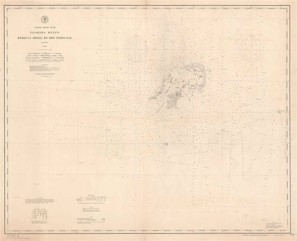
Coast Chart No. 171 Florida Reefs Rebecca Shoal to Dry Tortugas.
1889 (dated) 34 x 42 in (86.36 x 106.68 cm) 1 : 80000
1889 (dated) 34 x 42 in (86.36 x 106.68 cm) 1 : 80000
Description
This is an 1889 U.S. Coast and Geodetic Survey nautical chart of the Dry Tortugas Islands, a group of islands near the end of the Florida Keys. The chart focuses on the Dry Tortugas and depicts the region from west of the island group to Rebecca Shoal. Today, the Dry Tortugas and the surrounding area form the Dry Tortugas National Park. Myriad depth soundings populate the chart, with the greatest concentration about the islands. Each of the keys are labeled, including Loggerhead Key, Long Key, and Bush Key. Fort Jefferson is labeled, as are the light within Fort Jefferson and the light on Loggerhead Key. The channels through the islands are also identified. Information concerning lighthouses, buoys, soundings, and abbreviations used on the chart is situated in the lower left corner.
Publication History and Census
This chart was created and published by the U.S. Coast and Geodetic Survey in 1889. Three examples are recorded in the institutional collections of the University of Chicago, the Washington State Library, and Stanford University.CartographerS
The Office of the Coast Survey (1807 - present) founded in 1807 by President Thomas Jefferson and Secretary of Commerce Albert Gallatin, is the oldest scientific organization in the U.S. Federal Government. Jefferson created the "Survey of the Coast," as it was then called, in response to a need for accurate navigational charts of the new nation's coasts and harbors. The spirit of the Coast Survey was defined by its first two superintendents. The first superintendent of the Coast Survey was Swiss immigrant and West Point mathematics professor Ferdinand Hassler. Under the direction of Hassler, from 1816 to 1843, the ideological and scientific foundations for the Coast Survey were established. These included using the most advanced techniques and most sophisticated equipment as well as an unstinting attention to detail. Hassler devised a labor intensive triangulation system whereby the entire coast was divided into a series of enormous triangles. These were in turn subdivided into smaller triangulation units that were then individually surveyed. Employing this exacting technique on such a massive scale had never before been attempted. Consequently, Hassler and the Coast Survey under him developed a reputation for uncompromising dedication to the principles of accuracy and excellence. Unfortunately, despite being a masterful surveyor, Hassler was abrasive and politically unpopular, twice losing congressional funding for the Coast Survey. Nonetheless, Hassler led the Coast Survey until his death in 1843, at which time Alexander Dallas Bache, a great-grandson of Benjamin Franklin, took the helm. Bache was fully dedicated to the principles established by Hassler, but proved more politically astute and successfully lobbied Congress to liberally fund the endeavor. Under the leadership of A. D. Bache, the Coast Survey completed its most important work. Moreover, during his long tenure with the Coast Survey, from 1843 to 1865, Bache was a steadfast advocate of American science and navigation and in fact founded the American Academy of Sciences. Bache was succeeded by Benjamin Pierce who ran the Survey from 1867 to 1874. Pierce was in turn succeeded by Carlile Pollock Patterson who was Superintendent from 1874 to 1881. In 1878, under Patterson's superintendence, the U.S. Coast Survey was reorganized as the U.S. Coast and Geodetic Survey (C & GS) to accommodate topographic as well as nautical surveys. Today the Coast Survey is part of the National Oceanic and Atmospheric Administration or NOAA as the National Geodetic Survey. More by this mapmaker...
Julius Erasmus Hilgard (January 7, 1825 - May 9, 1890) was a German-American engineer and Director of the United States Coast Survey. Born in Zweibrüken, Rhenish Bavaria, he and his family emigrated to the United States in 1835. They arrived in New Orleans on Christmas Day and traveled from there to a farm in Belleville, Illinois. Hilgard went to Philadelphia in 1843 to study engineering. It was in Philadelphia that Hilgard met Professor Alexander Bache, the recently appointed Superintendent of the United States Coast Survey. In 1845, Bache gave Hilgard a position with the Coast Survey, although his official appointment was delayed for some reason until December 28, 1846. Hilgard worked with the Coast Survey off and on for the rest of his life. At the outbreak of the Civil War, Hilgard was engaged in a prominent business enterprise in Paterson, New Jersey, but Bache convinced him to return to the Coast Survey to supplement in the war effort. In 1862, Hilgard 'assumed charge of the Coast Survey office', taking on the duties of Superintendent in lieu of Bache, who had, by this time, become extremely ill. Upon Bache's death in 1867, Hilgard became the de-facto Superintendent as well as the assistant in charge of the office. He served as such until February 1867 when Benjamin Pierce was appointed Superintendent. Hilgard continued to work for the Coast Survey under Pierce as 'assistant in charge of office' until he was formally appointed Superintendent in 1881, a position he held until 1885 when he was forced to resign due to illness. He died 5 years later. Learn More...
Condition
Very good. Even overall toning. Light transference. Closed tear extending one half inch into printed area from right margin professionally repaired on verso. Blank on verso.
References
OCLC 317745140.