This item has been sold, but you can get on the Waitlist to be notified if another example becomes available.
1967 Longview Daily News Map of China's Nuclear Sites
RedChina-longviewdailynews-1967$150.00

Title
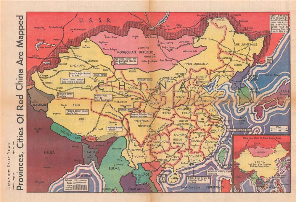
Provinces, Cities of Red China are Mapped.
1967 (dated) 14 x 21.5 in (35.56 x 54.61 cm) 1 : 12672000
1967 (dated) 14 x 21.5 in (35.56 x 54.61 cm) 1 : 12672000
Description
This is a 1967 Longview Daily News map of China emphasizing the rising communist power. The map was published three years after the People's Republic of China (PRC) tested their first nuclear weapons and is intended to emphasize the potential threat these weapons posed to the democratic world. White text boxes emphasize China's uranium mines, missile ranges, and main nuclear test site. American concern surrounding China joining the 'nuclear club' was heightened by the every-increasing American military presence in South Vietnam. Other text-boxes note Tibet's resentful relationship with China, Hong Kong as 'the British Crown Colony' and a 'listening post for the West', and 'Nationalist China's Island Stronghold' (Taiwan). The buffer zone between the Soviet Union and the PRC is marked by black diagonal lines. Both sides claimed these border areas, a dispute that would lead to the undeclared 1969 Sino-Soviet border war.
Publication History and Census
This map was published by Longview Daily News of Longview, Washington, on April 19, 1967. While this map was published in a newspaper, and presumably in a large run, this is the only surviving example we have located.Condition
Very good. Newsprint. Exhibits wear along original fold lines. Exhibits slight loss at fold intersection. Text on verso.