This item has been sold, but you can get on the Waitlist to be notified if another example becomes available, or purchase a digital scan.
1855 Public Survey Map of Red River, Louisiana
RedRiverLouisiana-publicsurvey-1855$100.00

Title
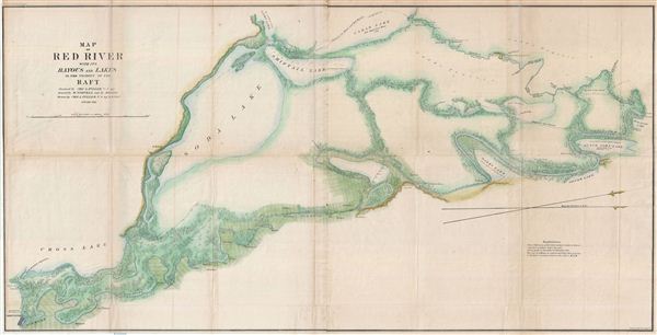
Map of Red River with its Bayous and Lakes in the Vicinity of the Raft.
1855 (dated) 23.5 x 46 in (59.69 x 116.84 cm)
1855 (dated) 23.5 x 46 in (59.69 x 116.84 cm)
Description
A large 1855 map following the course of the Red River from Shreveport, Louisiana to its confluence with the Red Bayou. This map was drawn by Charles A. Fuller to illustrate his travels on and inspection of the Red River. Using a simple raft, Fuller left Schreveport and began mapping the river in considerable detail with the expectation of various improvements intended to facilitate river commerce to follow. The map identifies numerous land holder s along the river as well as adjacent rivers and lakes that could be used to bypass the main river artery. This is also the first appears on any map of Albany (no longer extant) Louisiana, according to the Tourist's Description of Louisiana in 1860, a 'shipping point of some note' on Soda Lake. This map was engraved by Ackerman of Brooklyn, New York, for issue in the 1856 congressional report, Maps and Views to Accompany Message and Documents 1855-56.
Cartographer
The General Land Office (1812 - 1946) was an independent agency charged with the administration and sale of public lands of the western territories of the United States under the Preemption Act of 1841 and the Homestead Act of 1862. During a time of frenetic energy and rapid westward expansion, the Land Office oversaw the surveying, platting, mapping and eventually the sale of much of the Western United States and Florida. The structural layout of the western United States that we see today, and many of their district and county divisions, are direct result of the early surveying work of the General Land Office. More importantly, as a branch of the Federal Government in Washington D.C. and the only agency able to legally sell and administer public lands in the western territories of the United States, the General Land Office played a pivotal role in consolidating power away from the original states and into the hands of the centralized federal government. The General Land Office was absorbed into the Department of Interior in 1849 and in 1946 merged with the United States Grazing Service to become the Bureau of Land Management. Today the Bureau of Land Management administers the roughly 246 million acres of public land remaining under federal ownership. More by this mapmaker...
Source
Maps and Views to Accompany Message and Documents 1855-56, (Washington: Nicholson) 1856.
Condition
Very good. Original fold lines. Professionally flattened and backed with archival tissue. Some wear and toning on original fold lines.
References
Bagur, J., A History of Navigation on Cypress Bayou and the Lakes, p. 201.