This item has been sold, but you can get on the Waitlist to be notified if another example becomes available, or purchase a digital scan.
1870 War Office Map of the Red River Settlement, Manitoba (Red River Rebellion)
RedRiverSettlement-napierdawson-1870$750.00

Title
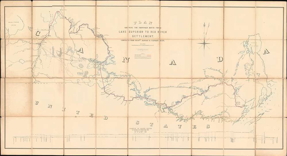
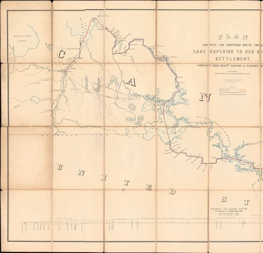
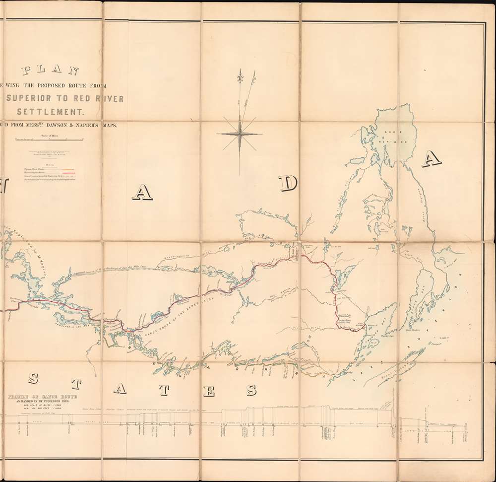
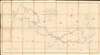
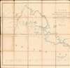
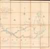
Plan Shewing the Proposed Route from Lake Superior to Red River Settlement.
1870 (dated) 34.5 x 63.75 in (87.63 x 161.925 cm) 1 : 500000
1870 (dated) 34.5 x 63.75 in (87.63 x 161.925 cm) 1 : 500000
Description
A most interesting and influential 1870 Canadian War Office map issued during the Red River Rebellion (1869 - 1870). The map covers from Lake Winnipeg and the Red River Settlement to the western shores of Lake Superior. It details two alternate river / lake / portage routes from Superior to Fort Garry, modern-day Winnipeg. The first being the traditional route, or 'Pigeon River Route', following the US - Canada border, the second being the longer but wholly Canadian 'Kaministiguia Route'. The map was issued by the War Department for the Wolseley Expedition, a military force sent to suppress the Red River Rebellion and prevent the Settlement's pending annexation by land-hungry Minnesotans. The outcome of the map and the Expedition was the 1870 creation of Manitoba as a province in the Canadian Confederation. The map would later be used for preliminary surveys anticipating the construction of a trans-Canadian railway.
In the words of Ignatius Donnelly (who incidentally is also responsible for the revival of the Atlantis myth in the late 19th century),
Although initially happy with Minnesotan support, the annexation proposal ultimately turned the Métis against the Americans. They instead, wanted support and formal admission into the Canadian Confederation as a new province with full citizenship rights - nonetheless, should push come to shove, they had little defense against an aggressive Minnesotan annexation attempt.
New Selkirk or the Red River Settlement
The Red River Settlement, also known as New Selkirk, roughly corresponds with modern-day Manitoba. Thomas Douglas (1771 - 1820) unexpectedly became the 5th Earl of Selkirk in 1799. He was an unlikely heir, as his ascension to that title required the death of his father and all six brothers! Douglas was concerned with the plight of Scottish and Irish crofters then being displaced by landlords, who were reclaiming their lands for more profitable sheepherding. Selkirk determined to resettle the homeless crofters in the New World. He initially used his wealth and estate to acquire lands in Prince Edward Island and in Upper Canada (Ontario). These lands proved insufficient, and Selkirk lobbied for more lands farther west. He reached out to the Hudson Bay Company, who had enormous territorial holdings in central and northern Canada - Rupert's Land. Although initially rebuffed, he leveraged his connections and wealth to acquire 40% of the HBC, putting them in no position to refuse. Selkirk received a grant for the entire Red River Valley, an area southwest of Lake Winnipeg nearly five times as large as Scotland, and extending into the present Minnesota and North Dakota. This area was at the very edge of HBC holdings and was thus also the stomping ground of the rival Montreal-based North West Company. Major NWC trade routes and supply chains ran directly through Selkirk's Grant. While initially friendly with the NWC, when food ran short, the Selkirk colonists shut down exports and trade, particularly of pemmican, a frontier food staple made from dried and powdered Buffalo meat. This led to the Pemmican War (1812 - 1821), between the HBC and NWC. Fought at frontier way-stations over rough forts, and between American Indian allies, the war lasted for nearly 10 years until the Hudson Bay and North West Companies merged in 1821 - magically putting aside past aggressions.The Métis
Over the subsequent 60 years the Red River Settlement grew, with English and French settlers intermarrying with the indigenous American Indians. The children of these unions were known as the Métis (mixed) and became a significant demographic. Most were of French and American Indian ancestry, the scions of the generations of French fur traders. They were thus predominantly Catholic and unified in their French values. The Métis had well-established land claims based on residency, but few formal rights.The Red River Rebellion
In 1869, the Canadian Confederation negotiated to purchase Rupert's Land - including the Red River Colony - from the Hudson Bay Company. The government in Ottawa sent a new English-speaking governor, William McDougall (1822 - 1905), who brought with him teams intent on resurveying the lands under the British public survey system. The mostly-Métis locals realized the new survey would reformat land ownership along the Red River. At the time, most of the Métis right-of-occupancy land claims were based upon the French seigneurial colonial system, with long narrow lots fronting the river. They were moreover unsupported by documentation. The new British-style survey, with its smaller square lots and bureaucratic approach, would diminish their property rights.Negotiating in Poor Faith
Métis opposing McDougall coalesced around Louis Riel (1844 - 1885), a formally educated Franco-Chipewyan. Riel rallied the Métis against McDougall, the Anglophone setters, supporting Métis land rights, their Roman Catholic faith, and social values. On December 27, 1869, he seized Fort Garry, modern-day Winnipeg, establishing the Métis National Committee, and declaring a provisional government with himself as president. Riel attempted to negotiate with the Canadian government in Ottawa, but efforts proved fruitless, largely because the Canadians were back-handedly plotting against the Métis.Minnesotan Annexationists
Meanwhile, Riel was in touch with American expansionists in Minnesota. Led by Senator Alexander Ramsey (1815 - 1903), Representative Ignatius Donnelly (1831 - 1901), and the merchants Zachariah Chandler (1813 - 1879) and Jacob M. Howard (1805 - 1871), the Minnesotans believed they could leverage Métis dissatisfaction to annex the Red River Settlement as an economic adjunct to their state. It made a great deal of sense, as the Red River was easily accessible via Minnesota and already part of a broad regional economy. Moreover, via the Red River, Minnesota connected the Red River Settlement to the growing American railroad network. Ottawa and Montreal, on the other hand, could only access the Red River Settlement via a complex network of rivers, lakes, and portages - as evident here.In the words of Ignatius Donnelly (who incidentally is also responsible for the revival of the Atlantis myth in the late 19th century),
With our great nation on the south of this region, and our new acquisition of Alaska resting on its northern boundary, British dominion will be inevitably pressed out of western British America. It will disappear between the upper and nether mill-stones. These jaws of the nation will swallow it up.
Although initially happy with Minnesotan support, the annexation proposal ultimately turned the Métis against the Americans. They instead, wanted support and formal admission into the Canadian Confederation as a new province with full citizenship rights - nonetheless, should push come to shove, they had little defense against an aggressive Minnesotan annexation attempt.
The Wolseley Expedition
Ottawa was not about to let the annexationists have their way. When word of the annexation sentiments in Minnesota reached Ottawa, a Canadian military expedition was dispatched to the Red River under the command of Colonel Garnet Wolseley (1833 - 1913). Although the government described it as an 'errand of peace', the force had every intention to arrest and execute Riel, reassert a British-Canadian Anglophone government, and suppress the 'Rebellion.'This Map
This map, made to support Wolseley's armed 'errand of peace' shows the routes from Lake Superior to the Red River Settlement. The yellow 'Pigeon River Route' demonstrates the traditional track, which followed the Canada - US border, and so was inadvisable given the annexationist sentiment in Minnesota. Instead, the map here details in red an alternate route surveyed roughly 13 years earlier by Simon James Dawson (1818 - 1902) and William Napier (1829 - 1894) - generally known as the 'Kaministiquia Route'. While far longer, covering some 450 miles, the 'Kaministiquia Route' ran entirely through Canadian territory. The Wolseley Expedition arrived in Fort Garry on August 24, only to find that Riel and his staunchest supporters had already fled to Minnesota.Creation of Manitoba
Riel was officially exiled for five years, but the Métis voice was heard, and sincere negotiations began. An agreement enshrining the Métis demands and rights was reached, the basis for the Manitoba Act of May 12, 1870, officially admitting Manitoba into the Canadian Confederation. Manitoba was the first province to be carved out of Canada's vast Northwest Territory.Publication History and Census
This is a purely military map, published in 1870 by the Topographical Depot of the War Officer, then under Captain C. W. Wilson, Royal Engineers. The base map is the Dawson map of 1857, but here exhibits numerous updates and revisions - including the important new northern route. This same map was revised and used to plan the Canadian Railroad - which would soon make the river routes illustrated here obsolete.Cartographer
The British War Office (1857 - 1964) was a department of the British Government responsible for the administration of the Royal Army until 1964, when its functions were transferred to the Ministry of Defense. The War Office was to the Royal Army what the Admiralty was to the Royal Navy, and later, the Air Ministry. Within the War Office, the General Staff Topographical Section was responsible for thousands of maps issued for British intelligence and military use. The Topographical Section was renamed Geographical Section in April 1907. Many, once their military use passed, were offered through licensed agents to the general public. The sole London agent for War Office material was Edward Stanford. More by this mapmaker...
Condition
Good. Some toning. Original linen split and reinforced in places. Wear on old fold lines.
References
University of Wisconsin, American Geographical Society, 141-c .R4R5 B-1870. OCLC 945615385.