This item has been sold, but you can get on the Waitlist to be notified if another example becomes available, or purchase a digital scan.
1794 Laurie and Whittle Nautical Map of the Red Sea from Moka to Geddah (Mecca)
RedSeaMokaGeddah-lauriewhittle-1794$475.00

Title
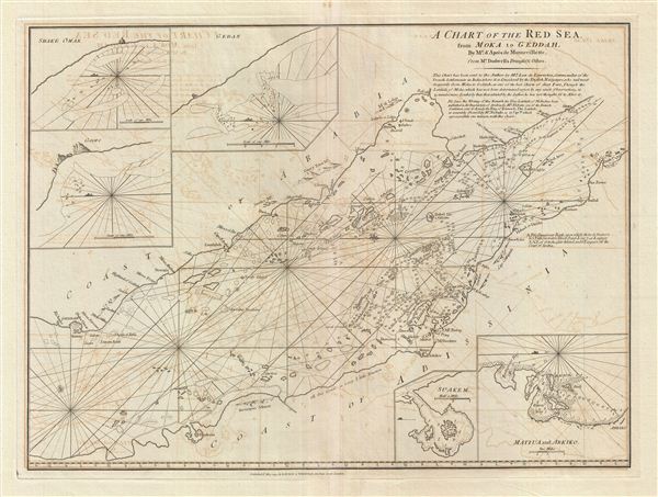
A Chart of the Red Sea from Moka to Geddah.
1794 (dated) 20 x 27 in (50.8 x 68.58 cm) 1 : 1720000
1794 (dated) 20 x 27 in (50.8 x 68.58 cm) 1 : 1720000
Description
A fine example of Laurie and Whittle's 1794 nautical chart or maritime map of the southern half of the Red Sea, roughly from Mecca (Jeddah, Geddah), to the Bab el Mandeb Strait (Mocha, Yemen and Assab, Eretria). The map is oriented with east at the top. Though important to global trade, a combination of numerous reefs, an unwelcoming coastline, and unpredictable wind patterns restricted mapping and made navigating the Red Sea exceptionally dangerous for sailing vessels. Consequently, the Red Sea was poorly understood dangerous to navigate well into the 19th century, until the rise of steam ships mitigated some of these issues. The general vagary of this map is illustrative of the overall lack of maritime reconnaissance in the region. The southern portions of the Red Sea are nonetheless considerably better mapped than the northern extensions - mostly due to the important pearl fisheries in the Dahlak Archipelago and the dangers associated with the constricted Bab el Mandeb passage.
When this map was issued, the most active maritime trade route in the Red Sea lie between Mocha (Moka) and Geddah. Mocha, today part of Yemen, was the world's largest exporter of coffee and is the source of the modern term 'mocha.' Geddah (Jeddah), further north was and is the maritime gateway for the Islamic Hajj to Mecca.
Insets illustrate Shake Omar, Gedan, Goofs, Suakem (Suakin, Sudan), Matuza (Massawa, Eretria) and Arkiko (Arqiqo, Eretria). A serious of curious annotations in the upper right quadrant offer insight into the history of this chart. It was originally prepared from a manuscript drawn by Mr. Dodwell. It was assumed, post-publication and based upon French reports that the map's situation of the coffee center Moka (Mocha) was off by some 15 minutes. Subsequent explorations by the Danish navigator Niebuhr confirmed that the location of Mocha as presented here is actually correct to within a minute.
This chart is cartographically derived from Jean-Baptiste d'Apres de Mannevillette's similar chart issued for the 1745 Neptune Oriental. It was twice reissued by Sayer and Bennet, and again, in this updated version by Laurie and Whittle, who acquired the Sayer and Bennet printing plates. The present Laurie and Whittle example is notable for several important updates based upon survey work conducted by the Danish navigator Mr. C. Niebuhr in 1762-3.
Cartographer
Laurie and Whittle (fl. 1794 - 1858) were London, England, based map and atlas publishers active in the late 18th and early 19th century. Generally considered to be the successors to the Robert Sayer firm, Laurie and Whittle was founded by Robert Laurie (c. 1755 - 1836) and James Whittle (1757-1818). Robert Laurie was a skilled mezzotint engraver and is known to have worked with Robert Sayer on numerous projects. James Whittle was a well-known London socialite and print seller whose Fleet Street shop was a popular haunt for intellectual luminaries. The partnership began taking over the general management of Sayer's firm around 1787; however, they did not alter the Sayer imprint until after Sayer's death in 1794. Apparently Laurie did most of the work in managing the firm and hence his name appeared first in the "Laurie and Whittle" imprint. Together Laurie and Whittle published numerous maps and atlases, often bringing in other important cartographers of the day, including Kitchin, Faden, Jefferys and others to update and modify their existing Sayer plates. Robert Laurie retired in 1812, leaving the day to day management of the firm to his son, Richard Holmes Laurie (1777 - 1858). Under R. H. Laurie and James Whittle, the firm renamed itself "Whittle and Laurie". Whittle himself died six years later in 1818, and thereafter the firm continued under the imprint of "R. H. Laurie". After R. H. Laurie's death the publishing house and its printing stock came under control of Alexander George Findlay, who had long been associated with Laurie and Whittle. Since, Laurie and Whittle has passed through numerous permeations, with part of the firm still extant as an English publisher of maritime or nautical charts, 'Imray, Laurie, Norie and Wilson Ltd.' The firm remains the oldest surviving chart publisher in Europe. More by this mapmaker...
Source
Laurie, R., and Whittle, J., The East-India Pilot, or Oriental Navigator, on One Hundred and Eighteen Plates: Containing a Complete Collection of Charts and Plans, &c., &c. for the Navigation not only of the Indian and China Seas, but of those also between England and the Cape of Good-Hope; Improved and Chiefly Composed from the Last Work of M. D'Apres de Mannevillette; with Considerable Additions, from Private Manuscripts of the Dutch, and from Draughts and Actual Surveys Communicated By Officers of the East-India Company A New Edition, Containing One Hundred and Five Charts. (London: Laurie and Whittle) 1797.
Condition
Very good. Minor wear and verso repair along original centerfold. Original platemark visible. Some offsetting.