This item has been sold, but you can get on the Waitlist to be notified if another example becomes available, or purchase a digital scan.
1680 Visscher Map of Denmark
RegniDaniae-visscher-1680$200.00

Title
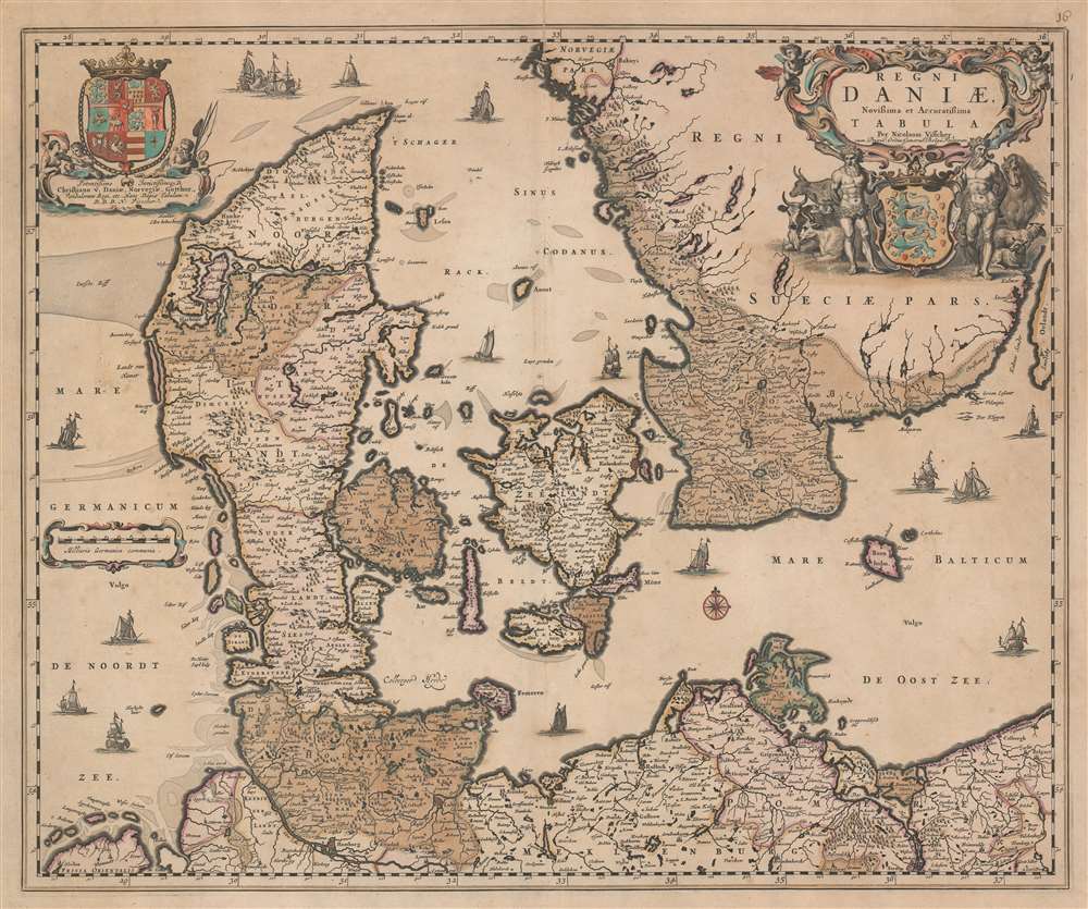
Regni Daniae, Novissima et Accuratissima Tabula.
1680 (undated) 18.75 x 22.5 in (47.625 x 57.15 cm) 1 : 1150000
1680 (undated) 18.75 x 22.5 in (47.625 x 57.15 cm) 1 : 1150000
Description
This is a c. 1680 Nicholas Visscher map of Denmark. The map depicts the region from the North Sea to the Baltic Sea and from Norway to Germany. Beautifully engraved, numerous cities, towns, and villages are labeled throughout Denmark and the illustrated portions of Sweden and Germany, including Copenhagen and Hamburg. Rivers, lakes, and forests are also noted. A decorative title cartouche is situated on the upper right and is balanced by the coat of arms of King Christian V. The whole was based on a survey completed by the royal geographer Johannes Mejer (1606 - 1674) along with Johann Wilhelm Lauremberg (1590 - 1656). In 1662, the cartographer Joan Blaeu (1598 - 1673) was the first to publish a map using data collected from this national survey.
Publication History and Census
This map was created and published by Nicholas Visscher c. 1680. Examples are part of the institutional collections at Harvard University, the Bibliothèque Nationale et universitaire in Strasbourg, France, the Koninklijke Bibliotheek in Den Haag, Netherlands, the Athenaeun Bibliotheek in Deventer, Netherlands, and the University of Bern.Cartographer
Claes Jansz Visscher (1587 - 1652) established the Visscher family publishing firm, which were prominent Dutch map publishers for nearly a century. The Visscher cartographic story beings with Claes Jansz Visscher who established the firm in Amsterdam near the offices of Pieter van den Keer and Jadocus Hondius. Many hypothesize that Visscher may have been one of Hondius's pupils and, under examination, this seems logical. The first Visscher maps appear around 1620 and include numerous individual maps as well as an atlas compiled of maps by various cartographers including Visscher himself. Upon the death of Claes, the firm fell into the hands of his son Nicholas Visscher I (1618 - 1679), who in 1677 received a privilege to publish from the States of Holland and West Friesland. The firm would in turn be passed on to his son, Nicholas Visscher II (1649 - 1702). Visscher II applied for his own privilege, receiving it in 1682. Most of the maps bearing the Visscher imprint were produced by these two men. Many Visscher maps also bear the imprint Piscator (a Latinized version of Visscher) and often feature the image of an elderly fisherman - an allusion to the family name. Upon the death of Nicholas Visscher II, the business was carried on by the widowed Elizabeth Verseyl Visscher (16?? - 1726). After her death, the firm and all of its plates was liquidated to Peter Schenk. More by this mapmaker...
Condition
Very good. Even overall toning. Blank on verso.
References
OCLC 1014233668.