This item has been sold, but you can get on the Waitlist to be notified if another example becomes available, or purchase a digital scan.
1876 Seelstrang / Tourmente Map of Argentina
RepublicaArgentina-seelstrang-1876$375.00

Title
Mapa de la Republica Argentina.
1876 (dated) 43.25 x 23.25 in (109.855 x 59.055 cm) 1 : 40000000
1876 (dated) 43.25 x 23.25 in (109.855 x 59.055 cm) 1 : 40000000
Description
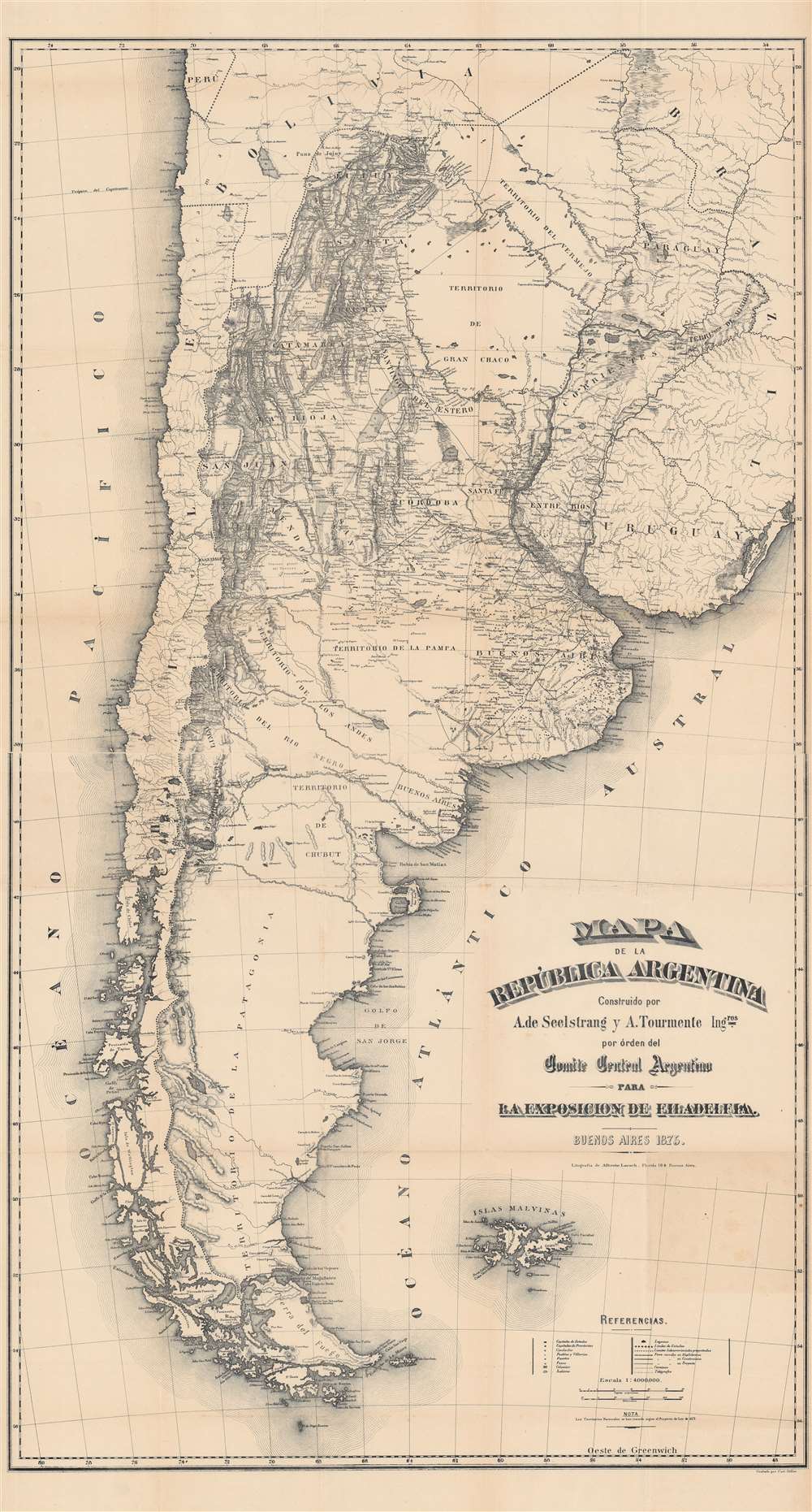
This is an important 1876 map of Argentina by Arturo Seelstrang and A. Tourmente produced for the Philadelphia Centennial Exposition to highlight the development and modernization of Argentina. Due to its comprehensiveness and accuracy, it became one of the most influential maps of Argentina in the late 19th century.
The legend indicates administrative divisions, settlements of various sizes (including colonias and forts), lines of communication and transportation, and geographic features, including massive salt flats in the country's north. The Andes Mountains dominate the left-hand portion of the map. To the bottom-right are the Islas Malvinas (Falkland Islands), which have been disputed between Argentina and Britain for nearly two centuries.
A Closer Look
The map covers the entire territory claimed by the republic in great detail, from the borders with Brazil and Bolivia down to Patagonia (contested at this time between Chile, Argentina, and several indigenous groups), paying particular attention to topography, reflecting Seelstrang's expertise in this field. Still, as is evident here, geographical knowledge about Patagonia was quite limited and few Argentinians ventured south of the Colorado and Negro Rivers. Only a handful of coastal colonias were inhabited by traders and Welsh migrants, a situation that would change dramatically in the following years.The legend indicates administrative divisions, settlements of various sizes (including colonias and forts), lines of communication and transportation, and geographic features, including massive salt flats in the country's north. The Andes Mountains dominate the left-hand portion of the map. To the bottom-right are the Islas Malvinas (Falkland Islands), which have been disputed between Argentina and Britain for nearly two centuries.
The 'Conquest of the Desert'
In the decades preceding this map's publication, Argentine military expeditions had attempted to exterminate resistant indigenous groups in Buenos Aires Province. Sporadic fighting continued afterwards, with Mapuche warriors led by Calfucurá attacking white settlements in 1872, killing dozens. In 1875, Mapuche resistance took the form of raids to steal cattle and other livestock from white farmers, who in response petitioned the government to take punitive action. At first, the government favored a defensive policy to pacify the frontier, building a line of forts connected by a massive trench (the zanja de Alsina) running roughly from Bahía Blanca to Mercedes to prevent raids. In the late 1870s, the government shifted towards an offensive policy, pursuing ethnic cleansing and even genocide against native people who opposed the Argentine state. Within a few years, the door was opened for white settlers to inhabit the former Indian lands across the Pampas and Patagonia, facilitated by a railway building boom. In doing so, the government was motivated both by competition with Chile and a desire to alleviate the economic difficulties caused by the Panic of 1873.Publication History and Census
This map was made by Arturo Seelstrang and A. Tourmente (no further information is available on this individual), engraved by Curt Stiller, and lithographed by Alberto Larsch. It is dated and generally cataloged as 1875, but was published to accompany the 1876 book Die Argentinische Republik, im Auftrag des Argentin-Central Comité's für die Philadelphia-Ausstellung (also published in Spanish and English) by Richard Napp and the Comité Central Argentino para la Exposición en Filadelfia. Later the same year, it was reprinted with colored ink as 'Nuevo mapa de la República Argentina,' published in Buenos Aires by Ernst Nolte Libreria Alemana. The present edition is only independently cataloged as belonging to the British Library and the Bibliothèque nationale de France and is scarce to the market.CartographerS
Arturo Seelstrang (May 1838 – November 30, 1896), sometimes as 'de Seelstrang' or 'von Seelstrang,' was a Prussian-born Argentinian mathematician, cartographer, and geographer. He arrived in Argentina in 1863 and spent the first part of his career conducting topographical surveys for different railway companies. Due to his accomplishments in exploring and surveying, he was invited to serve as a Professor of Topography and later a Dean of the Faculty of Physical-Mathematical Sciences of the National University of Córdoba. In 1880, Seelstrang was appointed a member of the National Academy of Sciences (Academia Nacional de Ciencias) and two years later he joined as a member of the Board of Directors. He was also a member of the Argentine Geographical Institute (Instituto Geográfico Argentino). Among his most important contributions were the Atlas of the Argentine Republic (Atlas de la República Argentina) and the 'Hypsometric map of the Argentine Republic' ('Mapa hipsométrico de la República Argentina'). More by this mapmaker...
Alberto Larsch (fl. c. 1875 – 1895) was a map printer active in Buenos Aires in the late 19th century who often lithographed maps by the prominent topographer and geographer Arturo Seelstrang. Learn More...
Curt Stiller (fl. c. 1871 – 1883) was a map engraver active in Buenos Aires in the late 19th century who was a frequent collaborator with the prominent topographer and geographer Arturo Seelstrang. Learn More...
Source
Napp, R., Die Argentinische Republik, im Auftrag des Argentin-Central Comité's für die Philadelphia-Ausstellung, (Buenos Aires: Sociedad anonima) 1876.
Condition
Good. Small areas of wear and loss along fold lines. Area of discoloration towards bottom-right.
References
OCLC 556399022, 494196827.