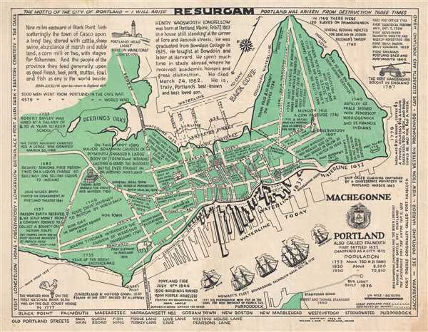
1932 Dow Pictorial City Map or Plan of Portland, Maine
ResurgamPortland-dow-1932$400.00

Title
Portland also called Falmouth First Settled 1632 Chartered as a City 1832.
1932 (dated) 16.25 x 20.5 in (41.275 x 52.07 cm) 1 : 8500
1932 (dated) 16.25 x 20.5 in (41.275 x 52.07 cm) 1 : 8500
Description
This is a 1932 William J. Dow city map or plan of Portland, Maine. The map depicts the entire city as it was in 1932, from Back Cove to the Fore River and from Deering to the mouth of the Fore River. Comprised of both the traditional and unusual, Dow combines the elements of a city plan, namely labeling streets and illustrating buildings in profile, with the novel, by referencing and depicting events in Portland's history.
First settled in 1632 and called Falmouth, Dow presents important events in Portland's history alongside the trivial. For example, Dow depicts the squadron of British ships under the command of Captain Henry Mowat that bombarded and burned the town as a 'just punishment' for it supporting the colonies' rebellion in 1775, marking the area of the town that burned. He also illustrates the parts that burned during the Great Fire of 1866 that was ignited by fireworks on July 4. Special recognition is given to the fact that American poet Henry Wadsworth Longfellow was born in Portland, and his childhood home is illustrated in profile. Visits from John Adams, and Lafayette are noted, along with the locations of battles, slave auctions, and the Rum Riot in Monument Square. Other, more trivial notations include the visit of Old Bet, an elephant owned by Hachaliah Bailey, in 1816. Bailey and Old Bet toured all around New England until she met a tragic end at the hand of a down-on-his-luck farmer in July 1816.
Dow also pays special attention to how the city has grown since its founding by illustrating how the waterline changed between 1632, 1832, and 1932. Beyond population growth, the city reclaimed land on all sides of its peninsula, allowing it to occupy more physical space. Dow even includes streets that did not exist in 1632 but do in 1932.
This map was created and published by William J. Dow in 1932. It is extremely rare on the market and we are aware of only two examples in institutional collections.
Condition
Good. Even overall toning. Light soiling. Small tears and areas infill along margins professionally repaired on verso. Closed one inch tear in upper right quadrant professionally repaired on verso. Blank on verso.
References
Boston Public Library, Leventhal Center, G3734.P8A5 1932 .D69. OCLC 916509103.