This item has been sold, but you can get on the Waitlist to be notified if another example becomes available, or purchase a digital scan.
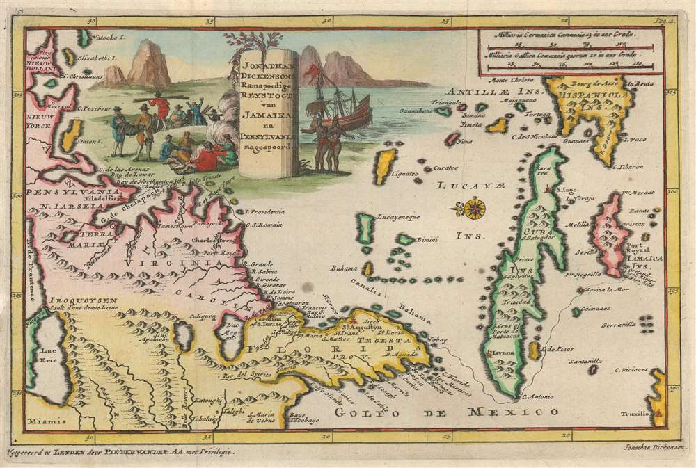
1707 Jonathan Dickinson Map of Florida, Carolina, Virginia and Cuba
ReystogtJamaika2-dickinson-1707$900.00

Title
Jonathan Dickensons Ramspoedige Reystogt van Jamaika na Pensylvania nagespoord.
1706 (undated) 7 x 10 in (17.78 x 25.4 cm) 1 : 14169600
1706 (undated) 7 x 10 in (17.78 x 25.4 cm) 1 : 14169600
Description
An exceptionally unusual and very rare 1707 map of the east coast of America prepared by the Dutch cartographer Pieter van der Aa. The map was prepared to illustrate the Dutch edition of journals describing the voyage, shipwreck, capture by Indians, and subsequent travels of Quaker merchant Jonathan Dickinson (1663 - 1722) and his family. Oriented to the east, Dickinson's map covers the eastern part of North America from roughly Lake Erie and New York south to Jamaica, including Virginia, Florida, the Carolinas, and Cuba. A dotted line indicates the path of Dickinson's travels from Port Royal, Jamaica, to Philadelphia, Pennsylvania.
Dickinson's narrative of his family's harrowing journey was originally published by the Society of friends in 1699 under the long title
Dickinson Captivity Narrative
In 1696, following a series of earthquakes that nearly destroyed Port Royal, Jamaica, Dickinson determined to pack up his family and settle with relatives in Philadelphia. He left Port Royal on board the barkentine Reformation on August 23rd of 1696. The Reformation proved an ill-fated ship with crew injuries and other mishaps occurring from the outset. Eventually the ship was separated from its escort vessel and, blown off course by a hurricane, shipwrecked on what is today Jupiter Inlet, Florida, not far from modern day Palm Beach. There they were taken captive by local Jaega Indians from the village of Jobe or, as Dickinson spells it, Hobay. This began a long saga of torture and abuse, in which the captives were stripped of all their possessions, beaten, feed starvation rations, and constantly mocked. Many died. Nonetheless, their pacifist Quaker values and reserve served them well, and their refusal to fight the local tribesmen, most likely saved their lives. The survivors slowly made their way northwards, pretending, usually unsuccessfully on account of their light hair, that they were Spanish, a nation with which the local tribes maintained a tentative peace. Eventually reaching St. Augustine they treated well by the Spanish governor. He sent them with supplies to Charleston (South Carolina) where they were able to catch a boat to Philadelphia. Ther he prospered and twice served as Mayor of Philadelphia, in 1712-1713 and 1717-1719/Dickinson's narrative of his family's harrowing journey was originally published by the Society of friends in 1699 under the long title
God's Protecting Providence Man's Surest Help and Defence in the times of the greatest difficulty and most Imminent danger Evidenced in the Remarkable Deliverance of divers Persons, from the devouring Waves of the Sea, amongst which they Suffered Shipwrack. And also from the more cruelly devouring jawes of the inhumane Canibals of Florida. Faithfully related by one of the persons concerned therein, Jonathan DickensonThe narrative was wildly popular and considered the best of a genre, popular at the time, known collectively as 'Indian Captivity Tracts'. After the English edition, the narrative was republished in the Netherlands, where the cartographer Van der Aa, added the above map.
Lacus acuqe dulcis
This map also has some additional cartographic features of considerable interest. There are two lakes of note in the upper left quadrant, one labeled 'Lac Magnus, (more commonly known as 'Lacus acuqe dulcis', as identified on many other maps), and a second identified as 'Apalatcy'. Both of these lakes make their first appearance on the De Bry / Le Moyne map of 1591. The largest of these is represented as the source of the River May. In that chart Le Moyne correctly mapped the River May (St. John’s River, Florida) in an inverted 'V' form, first heading north, then south to meet with a large inland lake (in all likely hood Lake George or one of the other great inland lakes of Florida). Hondius on the other hand maps the course of the May heading to the northwest, thus relocating the 'Lacus Aquae Dulcis' far to the north. This error can be understood in terms of magnetic variation, temperature issues associated with isothermal lines, and navigational errors related to the confusion of the star Asfick with Polaris. While Le Moyne correctly located the mouth of the River May at 30 degrees of latitude, Hondius maps it between 31 and 32 degrees. This led to a misassociation of the River May with the Savannah River. Thus, while the real River May dips southward, the Savannah River heads almost directly NW into the Appalachian Mountains, forming the modern southern border of South Carolina. Hondius, no doubt taking his cue from navigators who rarely trekked inland, therefore rerouted the May River to flow from the northwest. Without an accurate picture of the interior, Hondius followed Le Moyne’s example and translocated the great freshwater lake to the north. Others have speculated that the Le Moyne’s River May is in fact the St. John’s River and that the 'Lacus Aquae Dulcis' is in fact the Okefenokee Swamp - however, this argument runs counter most scholarship. The influence of the Mercator-Hondius firm was so pronounced in Europe that most subsequent cartographers, including as we see her Van der Aa, followed their lead.Lake Apalatcy
Lake Apalatcy, further north, also bears some discussion. Both the De Bry / Le Moyne and the Honduis / Mercator maps of this region depict this map originating from a great waterfall plunging from between a cleft in the mountains. Some have speculated that this may have derived from early indigenous reports of Niagara Falls, but this seems doubtful. Be that as it may, Van der Aa is here one of the first to depict this lake without the hallmark waterfall. Most subsequent cartographers abandoned the lake altogether.Publication History and Census
It was later republished in Dutch and German. The present map, by the Dutch printer Pieter van der Aa, accompanied the Dutch edition published in 1707, for which it was prepared. The English edition did not contain a map. Rare on the market.Cartographer
Pieter van der Aa (1659 - 1733) was a Dutch publisher of maps and atlases active in the late 17th and early 18th centuries. Van der Aa was born in Leyden in 1659. At nine he was apprenticed to a local bookseller and, by 21, had established his own publishing, printing, and auctioneering house. In 1692 Van der Aa was appointed to be one of the High Commissioners of the Booksellers Guild. During his long and impressive career Van der Aa produced thousands of maps, including a vast 28 volume atlas containing no less than 3,000 maps. Few of Van der Aa's maps were original productions, most being copied from the work of earlier cartographers. Nonetheless, when one of Van der Aa's rare original pieces does appear, his style, with unusual projections, elegant engraving, and precise detail, is instantly recognizable and highly desirable. He also pioneered the cartographic idea of separating border artwork from the map plate itself such that every map in a collection could have a similar elaborate border without actually having to re-engrave the complex plates. This technique was used to great effect by later 18th century publishers like Brion de la Tour. Following Van der Aa's death in 1733, his much admired Nouvel Atlas was reissued by the Dutch firm of Covens & Mortier. Today Van der Aa's work is admired for its fine delicate engraving and unusual projections and is considered highly desirable among collectors. More by this mapmaker...
Source
Dickinson, J., Ongelukkige schipbreuk en yslyke reystogt, van etlyke Engelschen, in den jaare 1696 van Jamaika in West Indien, na Pensylvania, (Leiden) 1707.
Condition
Very good. Original platemark visible. Original fold line visible.
References
Brown University, John Carter Brown Library, F707 N111v. Howes, W., U.S.iana (1650-1950): A Selective Bibliography in which are Described 11,620 Uncommon and Siginficant Books Relating to the Continental Portion of the United States, D317. Newberry Library: Ayer 74. Sabin, J., A dictionary of books relating to America: from its discovery to the present time, 20017. Servies, J. A., A Bibliography of West Florida, 262.