1988 U.S. Geological Survey Map or Photomosaics of Rhea, Moon of Saturn
RheaPhotomosaics-usgs-1988$150.00

Title
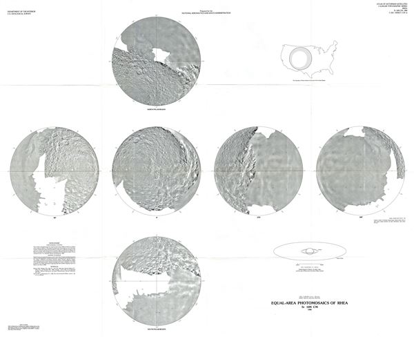
Equal-Area Photomosaics of Rhea.
1988 (dated) 33 x 40 in (83.82 x 101.6 cm) 1 : 10000000
1988 (dated) 33 x 40 in (83.82 x 101.6 cm) 1 : 10000000
Description
This is a fine example of the U.S. Geological Survey's 1988 map or photomosaics of Rhea, Saturn's second largest moon. The map features six equal-area photomosaics on the Lambert azimuthal projection. These include the South Polar Region and the North Polar Region. A diagram of Rhea relative to the size of the United States is included in the upper right quadrant, while the lower right quadrant features a scaled diagram of Saturn, its major rings, and the orbit of Rhea and of the Earth-Moon system.
The image processing and mosaic compilation for this map were done by Ella M. Lee. This map or photomosaic was prepared for the National Aeronautics and Space Administration and published by the U.S. Geological Survey as Atlas of Saturnian Satellites Topographic Series Sr 10M CM map I-1921 sheet 2.
The image processing and mosaic compilation for this map were done by Ella M. Lee. This map or photomosaic was prepared for the National Aeronautics and Space Administration and published by the U.S. Geological Survey as Atlas of Saturnian Satellites Topographic Series Sr 10M CM map I-1921 sheet 2.
Cartographer
The Office of the Coast Survey (later the U.S. Geodetic Survey) (1807 - present), founded in 1807 by President Thomas Jefferson and Secretary of Commerce Albert Gallatin, is the oldest scientific organization in the U.S. Federal Government. Jefferson created the "Survey of the Coast," as it was then called, in response to a need for accurate navigational charts of the new nation's coasts and harbors. The first superintendent of the Coast Survey was Swiss immigrant and West Point mathematics professor Ferdinand Hassler. Under the direction of Hassler, from 1816 to 1843, the ideological and scientific foundations for the Coast Survey were established. Hassler, and the Coast Survey under him developed a reputation for uncompromising dedication to the principles of accuracy and excellence. Hassler lead the Coast Survey until his death in 1843, at which time Alexander Dallas Bache, a great-grandson of Benjamin Franklin, took the helm. Under the leadership A. D. Bache, the Coast Survey did most of its most important work. During his Superintendence, from 1843 to 1865, Bache was steadfast advocate of American science and navigation and in fact founded the American Academy of Sciences. Bache was succeeded by Benjamin Pierce who ran the Survey from 1867 to 1874. Pierce was in turn succeeded by Carlile Pollock Patterson who was Superintendent from 1874 to 1881. In 1878, under Patterson's superintendence, the U.S. Coast Survey was reorganized as the U.S. Coast and Geodetic Survey (C & GS or USGS) to accommodate topographic as well as nautical surveys. Today the Coast Survey is part of the National Oceanic and Atmospheric Administration or NOAA. More by this mapmaker...
Source
Miscellaneous Investigations Series. Department of the Interior. United States Geological Survey.
Condition
Very good. Original fold lines visible. Blank on verso.