This item has been sold, but you can get on the Waitlist to be notified if another example becomes available, or purchase a digital scan.
1945 WWII Advance Section Communications Zone Map of Rhine River Railroad Bridges
RhineRiverRailroadBridges-adsec-1945$125.00

Title
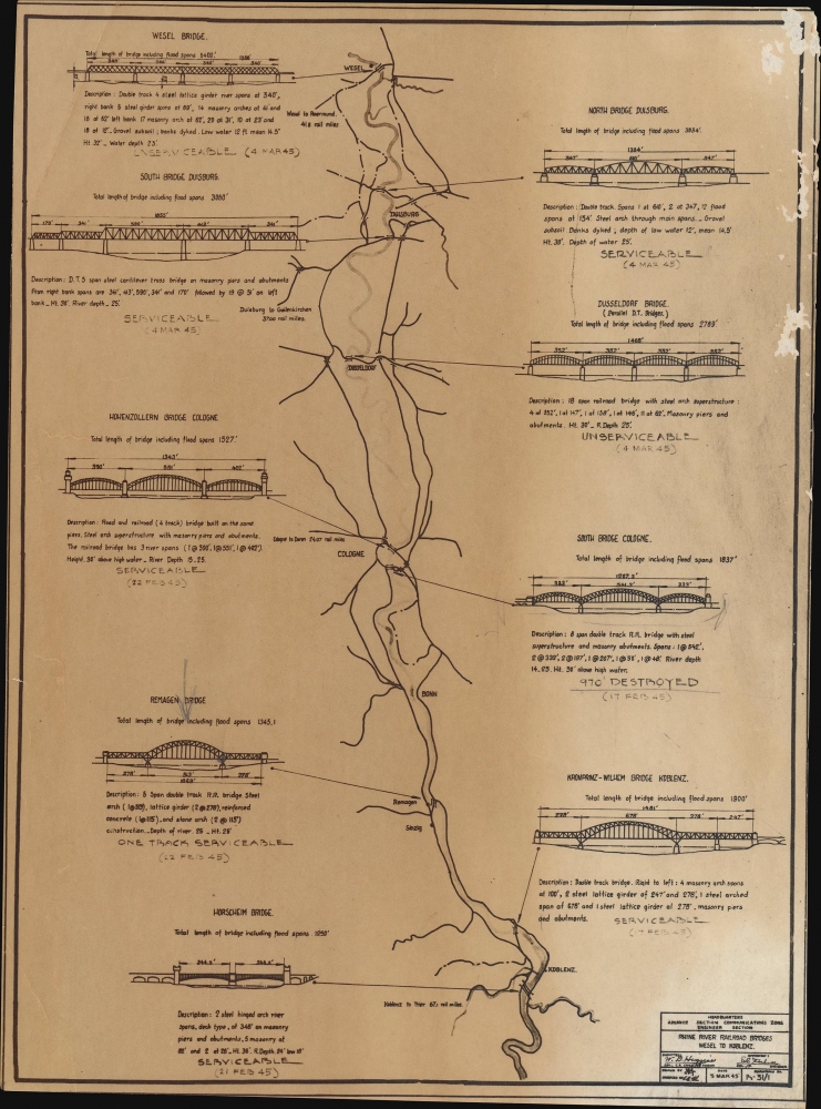
Rhine River Railroad Bridges Wesel to Koblenz.
1945 (dated) 10.5 x 7.75 in (26.67 x 19.685 cm)
1945 (dated) 10.5 x 7.75 in (26.67 x 19.685 cm)
Description
A most important previously unrecorded March 1945 Advance Section Communications Zone map of the railroad bridges across the Rhine River between Wesel and Koblenz, Germany. Crossing the Rhine was the last major obstacle for the World War II (1939 - 1945) Allied armies and came to be seen as a mythic accomplishment for American soldiers.
A Closer Look
The map highlights the nine railroad bridges that spanned this section of the river. An illustration of each appears with short description detailing structure, length, width, and other data.Bridges Across the Rhine and the Battle of Remagen
Crossing the Rhine River was one of the most significant military engineering challanges of the European Theater and one of the final hurdles to victory. Of the 22 road and 25 railroad bridges that once traversed the Rhine, as of March 1, 1945, only four stood. These were the Hohenzollern Bridge at Cologne (destroyed on March 6 by Germans), the Ludendorff Bridge at Remagen (captured on March 7 by Americans), the Rhine Bridge at Bonn (destroyed on March 8 by Germans), and the Crown Prince Wilhelm Bridge at Urmitz (destroyed on March 9 by Germans). The Americans' surprising capture of the Ludendorff Bridge at Remagen on March 7 came two weeks before Bernard Montgomery's meticulously planned river crossing. The bridge stood for another ten days, allowing the crossing of 125,000 Allied troops, along with tanks, artillery, trucks, and supplies. During those ten days, the Germans attempted to destroy the bridge with everything they had: turbojet bombers, sappers, howitzers, armor, and V-2 rockets. The Americans, likewise, did everything they could to defend the bridge, leading to some of history's most extensive antiaircraft engagements. By the time the bridge collapsed on March 17, army engineers had assembled two temporary bridges across the Rhine, making its collapse a sustainable blow. The capture and holding of the Ludendorff Bridge shortened the war in Europe significantly, as since it allowed the Allies to continue their lightning advance and prevented the Germans from fortifying their positions.Publication History and Census
This map was published by the Engineer Section of the Headquarters of the Advance Section Communications Zone on March 5, 1945. It is a reduced example of a larger map, suggesting that smaller copies such as this were made for quick reference in the field. This is the only known surviving example of any edition of this map, and we have found no references to it in any literature.Condition
Very good. Scuffing along right border.