1838 Bradford Map of Rhode Island
RhodeIsland-bradford-1838$300.00

Title
Rhode Island.
1838 (dated) 15 x 12 in (38.1 x 30.48 cm) 1 : 290000
1838 (dated) 15 x 12 in (38.1 x 30.48 cm) 1 : 290000
Description
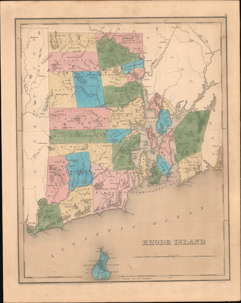
This is an 1838 Thomas G. Bradford map of Rhode Island.
A Closer Look
The map embraces all of Rhode Island as well as parts of adjacent Connecticut and Massachusetts. It also includes Block Island, just breaking the border at the bottom edge. The Stonington Railroad traverses nearly the entire state, crossing the border from Connecticut in Westerly County not far from the Atlantic coast and continuing diagonally to Providence. The railroad to Boston continues from Providence northeast through Massachusetts. The Blackstone Canal runs parallel to the Blackstone River north of Providence. Factories are labeled throughout the state, highlighting Rhode Island's industrial economy.Historical Context
In 1838, Rhode Island stood at the forefront of the American Industrial Revolution, with the proliferation of textile mills and other industry. These developments stemmed from innovations introduced in the late 18th century. Concurrently, the state grappled with socio-political tensions over voting rights, as property ownership remained a prerequisite, disenfranchising a significant portion of adult males. This issue would eventually escalate, leading to movements like the Dorr Rebellion in the early 1840s. Additionally, the broader U.S. economic downturn, initiated by the Panic of 1837, impacted Rhode Island's industrially-driven economy, setting the stage for a decade of both challenges and transformations.Publication History
This map was engraved by George Boynton in 1838 and published in the 1841 edition of Bradford and Goodrich's A Universal Illustrated Atlas. The map received regular updates through the late 1840s.CartographerS
Thomas Gamaliel Bradford (1802 - 1887) was born in Boston, Massachusetts, where he worked as an assistant editor for the Encyclopedia Americana. Bradford's first major cartographic work was his revision and subsequent republishing of an important French geography by Adrian Balbi, Abrege de Geographie published in America as Atlas Designed to Illustrate the Abridgment of Universal Geography, Modern and Ancient. Afterwards Bradford revised and expanded this work into his own important contributions to American cartography, the 1838 An Illustrated Atlas Geographical, Statistical and Historical of the United States and Adjacent Countries. Bradford's cartographic work is significant as among the first to record Texas as an independent nation. In his long career as a map publisher Bradford worked with William Davis Ticknor of Boston, Freeman Hunt of New York, Charles De Silver of Philadelphia, John Hinton, George Washington Boynton, and others. We have been able to discover little of Bradford's personal life. More by this mapmaker...
George Washington Boynton (fl. c. 1830 - 1850) was a Boston based cartographer and map engraver active in the first half of the 19th century. Boynton engraved and compiled maps for numerous publishers including Thomas Bradford, Nathaniel Dearborn, Daniel Adams, and S. G. Goodrich. His most significant work is most likely his engraving of various maps for Bradford's Illustrated Atlas, Geographical, Statistical, and Historical, of the United States and the Adjacent Countries and Universal Illustrated Atlas. He also engraved for the Boston Almanac. In 1835, Boynton is listed as an employee of the Boston Bewick Company, an engraving, stereotype, and printing concern based at no. 47 Court Street, Boston. Little else is known of his life. Learn More...
Source
Bradford, T. G. and Goodrich, S. G., A Universal Illustrated Atlas, exhibiting a Geographical, Statistical, and Historical view of the World, (Boston: Charles D. Strong) 1841.
The Universal Illustrated Atlas is one of the great American atlases of the first half of the 19th century. The atlas was first published in 1838 under the imprint of Charles D. Strong. It replaced and superseded Bradford's earlier smaller format Illustrated Atlas, Geographical, Statistical, and Historical, of the United States and the Adjacent Countries. Numerous reissues of the Universal Illustrated Atlas followed until about 1848. Although there are minor variations between the editions, most contain about 50 maps, the majority of which focus on the United States. Bradford's atlases are significant for recording North America during the Republic of Texas Era. In later editions, particularly the 1846 edition, Bradford illustrates the boom in railroad construction, possibly with the idea that his maps would aid travelers in planning journeys by rail. It was compiled by Thomas Gamaliel Bradford and Samuel Griswold Goodrich with most of the plates engraved by George Washington Boynton (fl. c. 1830 - 1850). Other contributors include Thomas Gordon (1778 - 1848), Fielding Lucas Jr. (1781 - 1854), Samuel Edward Stiles (1844 - 1901), Sherman and Smith (fl. c. 1829 - 1855), and Horace Thayer (1811 - c. 1874).
Condition
Very good. Even overall toning. Some spotting.
References
Rumsey 4453.013.