This item has been sold, but you can get on the Waitlist to be notified if another example becomes available, or purchase a digital scan.
1835 Lucy Durfee Manuscript Schoolgirl Map of Rhode Island - Americana
RhodeIsland-durfee-1835$750.00

Title
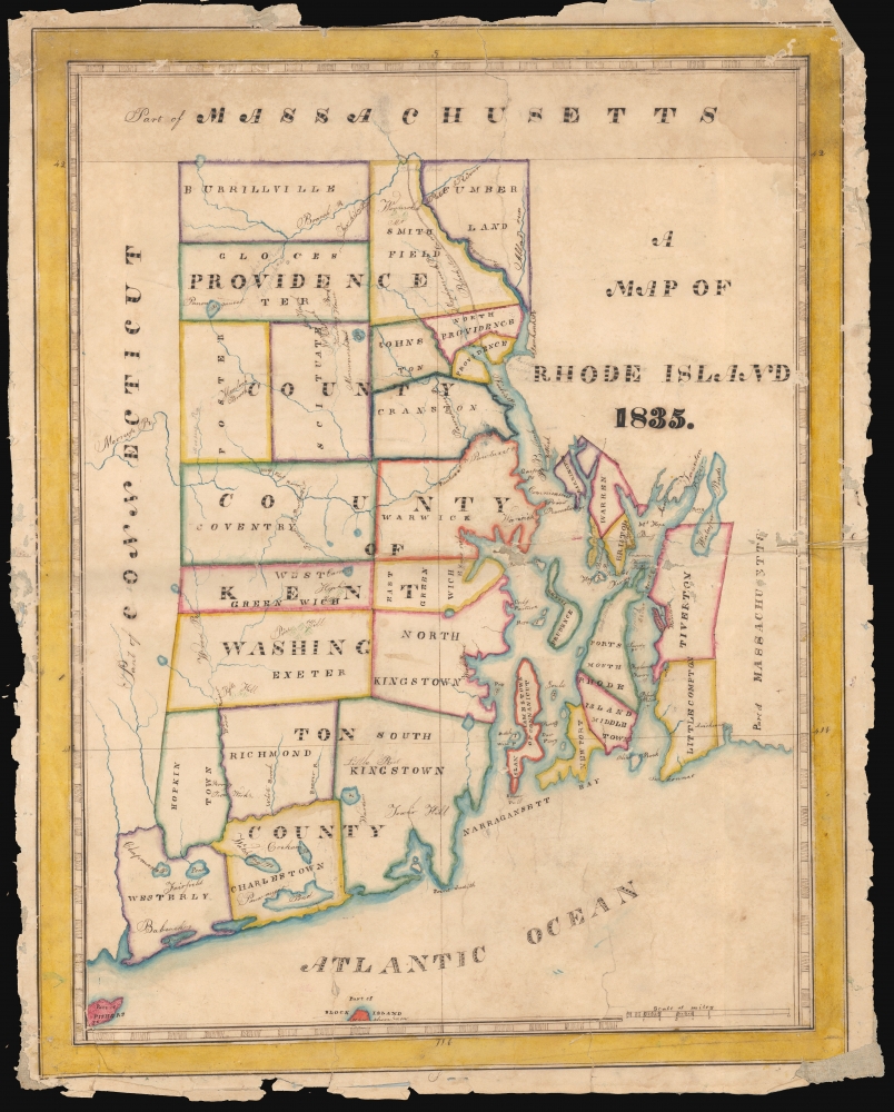
A Map of Rhode Island 1835.
1835 (dated) 20.75 x 16.25 in (52.705 x 41.275 cm) 1 : 202000
1835 (dated) 20.75 x 16.25 in (52.705 x 41.275 cm) 1 : 202000
Description
This is a beautifully executed schoolgirl map of Rhode Island, drawn in 1835 by Lucy Durfee (conjecturally the daughter of legislator and congressman Job Durfee).
A Closer Look
The map illustrates the State of Rhode Island, divided into counties, and indicating important cities and towns. Like most schoolgirl maps, this is executed on paper with pen, ink, and watercolors. Hills are indicated pictorially, with an elegance modeling the engraved maps of the period. Rivers are carefully drafted and named as well, showing that the mapmaker had good references, which she was following scrupulously. The detail in the north and east parts of the map is markedly sharper than elsewhere, suggesting familiarity. The map is neatly lettered (more so in the larger lettering than in the finer print, admittedly). The present example was treasured from an early date, as indicated by having been mounted on linen for preservation.The Source
Schoolgirl maps, necessarily, were drawn based on the maps of their respective regions found in popular atlases of their day. While two of the Durfee maps we have surveyed draw from the 1829 Olney A New and Improved School Atlas, that work did not contain a separate Rhode Island map. On the other hand, the 1826 Finley New American Atlas contained a Rhode Island which featured much of the toponymy of this work, and so it seems the best fit - also, Durfee's map of the United States was drawn from the Finley, so both in terms of the source material and availability it is the best candidate.Identifying the Author
We acquired this along with three other maps (the United States, Rhode Island, and Europe), two of which are signed by Lucy Durfee. Since such 'schoolgirl maps' were student works of young women virtually all destined for marriage and motherhood, it is difficult be completely certain of the identity of its young author. We do find a Lucy Durfee (1821 - 1890), who represents a compelling possibility. She was the eldest daughter of a Rhode Island lawyer, lawmaker, and congressman with a literary bent. His household would certainly have had the resources clearly available to the author of this map, and such an individual can be expected to have educated his daughter as a Federalist citizen and mother of the next generation of engaged and patriotic Americans.Schoolgirl Maps
While the use of mapmaking in teaching is first seen in Europe, mainly England, the Schoolgirl Map became a peculiarly American pedagogical tool in the first part of the 19th century, a period in which standards and purposes in women's education were changing. While boys were frequently taught the practical execution of surveys and charts, the production of attractive and informative maps was primarily the domain of young women. Such maps can be found of the World, the United States, or individual states. These were based on generally available reference maps, such as those found in the atlases produced by Carey and Lea, Finley, and Mitchell.Goals
The goals of these exercises were more far-reaching than geography. Girls learned penmanship, each map often using three or more lettering styles. Mapmaking further sharpened the retention and recall of factual information. Students were encouraged to take pains in their draftsmanship, often achieving beautiful artistic flourishes. But most peculiar to the American iterations of educational mapping was the goal of instilling a sense of civic pride and responsibility. Indeed, the desired result of girls' education in the post-Revolutionary United States was to prepare for the education of the next generation of American citizens, a patriotic duty that would primarily fall on the shoulders of these young women.Publication History and Other Examples
For a good overview, see Betty Mason's '19th Century Schoolgirls Were Incredibly Good at Drawing Maps.' Published July 27, 2016, by National Geographic.CartographerS
Lucy Durfee (Borden) (January 18, 1821 - July 26, 1890) was a Rhode Islander; she was born, lived, and died in Tiverton near Newport. Her father, The Hon. Job Durfee, LL.D. (1790 - 1847), was a lawyer, state legislator, a federalist congressman, a poet, and author. Lucy, the eldest of seven siblings - at least one of whom was an author as well - would have been brought up in a literate and studious household. While she appears to have published nothing, in her youth she would have been educated in the early American vein, intended to make her better able to raise a generation of literate, politically intelligent young Americans. As evidence of this, there are no fewer than four 'schoolgirl' maps in her hand that have survived. In 1846 she married Thomas Hicks Borden, with whom she raised at least eight children, to whom it is to be hoped that she passed along her studiousness and curiosity. More by this mapmaker...
Anthony Finley (August 25, 1784 - June 9, 1836) was an American book and map publisher based in Philadelphia, Pennsylvania. Finley was born in Philadelphia in 1784. He opened a bookshop and publishing house at the Northeast corner of Fourth and Chestnut Street, Philadelphia in 1809. His earliest known catalog, listing botanical, medical and other scientific works, appeared in 1811. His first maps, engraved for Daniel Edward Clarke’s Travels in Various Countries of Europe, Asia, and Africa also appear in 1811. His first atlas, the Atlas Classica, was published in 1818. He soon thereafter published the more significant A New American Atlas and the New General Atlas…, both going through several editions from 1824 to 1834. Although most of Finley's cartographic material was borrowed from European sources, his atlases were much admired and favorably reviewed. In addition to his work as a printer, Finley ran unsuccessfully on the 1818 Democratic ticket for Philadelphia Common Council. He was a founding officer of the Philadelphia Apprentices’ Library, and a member of both the American Sunday-School Union and the Franklin Institute. He was also an ardent supporter of the American Colonization Society, an organization dedication to returning free people of color to Africa - which led to the founding of Liberia. Much of his wealth was dedicated to supporting this cause. Finley was active as a publisher until his 1836 death, apparently of a 'lingering illness.' Shortly thereafter advertisements began appearing for his map business and plates, most of which were acquired by Samuel Augustus Mitchell. Learn More...
Condition
Fair. Manuscript pen, ink and watercolor on paper; mounted for preservation on old linen. Margins much cracked with very little impact to border. Some small areas of scuffing and loss, else very sightly.