
1935 Huber Pictorial Map of Rhodes, Greece

Rodi. Rhodes. Rhodos.
The Colossus of Rhodes!
$1,000.00
Choose a Collection:
- Digital Map Information
- Suitable for large format printing
- Full resolution TIFF file
- ICC color profile embedded
- Delivered instantly via download link
This Item
Enquire
The Colossus of Rhodes!
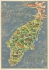
This is a 1935 Egon Huber pictorial map of Rhodes.A Closer Look
The Colossus of Rhodes (one of the Seven Wonders of the Ancient World) dominates the image. Cities and towns and the island's picturesque countryside are beautifully illustrated. A knight carrying a shield bearing the symbol of the Knights Hospitaller (headquartered on Rhodes from 1310 to 1522) is illustrated slaying a dragon. Groups of Rhodians are illustrated dancing, picking grapes, hunting, weaving, and celebrating. The Rosa d'Oro, a now-defunct automobile race in Rhodes, is illustrated near the bottom of the island. A view of the city of Rhodes appears in the upper left. The white lines and background color lend a slightly eerie air to the illustration.Egon Huber
We have been unable to unearth concrete information about this map's creator, Egon Huber. The overwhelming consensus among reference sources is that he was born in 1926 and arrived on Rhodes in 1931. He then became a successful potter and worked with ICARO / IKAROS pottery on Rhodes, where he eventually became the technical director of the IKAROS factory. If that birth date is correct, that would mean that Huber was nine when he created this pictorial map of Rhodes, which raises more questions than it answers.Publication History and Census
This map was drawn by Egon Huber and published by the Italian State Tourist Department (ENIT) in 1935. We note two cataloged examples. One is part of the collection at Princeton University, and the other appears in OCLC and is part of the collection at the National Library of Israel. This map occasionally appears on the private market.Condition
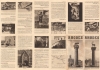
Very good. Light wear along original fold lines. Exhibits a very slight area of loss just to the left of 'Rodi' in title. Text and printed images on verso.
References
Princeton University HMC01.6516. OCLC 907802589.