This item has been sold, but you can get on the Waitlist to be notified if another example becomes available, or purchase a digital scan.
1968 Ordnance Survey Map of Richmond Park (Royal Parks), London, England
RichmondPark-ordnancesurvey-1968$50.00

Title
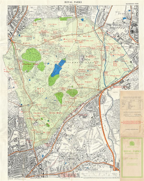
Royal Parks Greater London. Richmond Park.
1968 (dated) 35 x 27 in (88.9 x 68.58 cm) 4.441666667
1968 (dated) 35 x 27 in (88.9 x 68.58 cm) 4.441666667
Description
This is a beautiful example of the 1968 Ordnance Survey map of Richmond Park, one of the Royal Parks of London, England. It covers all of Richmond Park and its vicinity. The map is highly detailed with the parks beautifully rendered. Streets, important buildings, cemeteries, ponds and other topographical details are noted throughout. The Royal Parks of London, part of the hereditary possessions of the Crown, were originally owned by the monarchy of the United Kingdom and used for recreation and hunting by the royal family. Originally created as a deer park by Charles I, Richmond Park is today the largest of the Royal Parks of London. The red lines in this map indicate the old field boundaries over the area of Richmond before the 'Act of Enclosure of Charles the First in 1637,' and the old English red font shows old place names. This map was printed and published by the Director General of the Ordnance Survey, Southampton in 1968 for the Ministry of Public Buildings and Works.
Cartographer
The British Ordnance Survey (1791 - present) is the national mapping agency of Great Britain and is one of the largest producers of maps in the world. This non-ministerial department of the government of the United Kingdom is responsible for producing maps of Great Britain and many of its overseas possessions. The history of the Ordnance Survey goes back as far as 1747, following the Jacobite rising, when King George II commissioned a comprehensive military survey of Scotland to assist further campaigns. The result, produced by Paul Sandby, John Mason and William Roy, was the Duke of Cumberland's Map, the first military quality map of the British Isles. This grew into the Principal Triangulation of Great Britain (1783-1853) under William Roy, and eventually lead to the creation of the Ordnance Survey in 1791. Today the Ordnance Survey produces a large variety of paper maps and digital mapping products. Its large scale maps, issued to the scale of 1:10000, available in sheet map form until the 1980s, are now only available digitally. All maps produced by the Ordnance Survey are in copyright for 50 years after publication. More by this mapmaker...
Condition
Very good. Minor wear along original fold lines. Blank on verso.