This item has been sold, but you can get on the Waitlist to be notified if another example becomes available, or purchase a digital scan.
1953 Pictorial Bird's Eye View Map of Southern California
RoadsToRomance-roadtoromanceinc-1953$112.50

Title
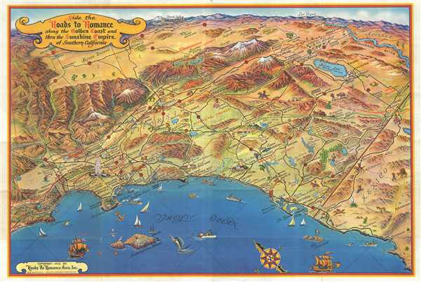
Ride the Roads to Romance along the Golden Coast and thru the Sunshine Empire of Southern California.
1953 (dated) 22 x 34 in (55.88 x 86.36 cm)
1953 (dated) 22 x 34 in (55.88 x 86.36 cm)
Description
This is an attractive 1953 bird’s eye view map of southern California issued by the Roads to Romance Association, Inc. It covers from Malibu Beach to Ensenada in Mexico and includes the counties of Los Angeles, Orange, Riverside, San Diego, Imperial and San Bernardino. Las Vegas and Death Valley appear on the horizon. Throughout missions, trails, places of interest, historic sites and natural wonders are represented pictorially, including Malibu Beach, Beverly Hills, Venice, Santa Monica, Laguna Beach, Calico ghost town, Bristol dry lake, twenty nine palms, Mission Bay aquatic park, Anza Trail 1774-76, Butterfield Trail 1858 etc. Roads, lakes, trails and camps are also identified. Fun illustrations of fruits, boats in the ocean and people engaged in recreational activities are seen throughout. Verso contains images and information promoting Long Beach, California. This map was part of the Roads to Romance series that ran during the 1940s and 1950s to promote tourism in Southern California. Copyrighted in 1953 by Roads to Romance Assn. Inc. in Long Beach, California.
Condition
Very good. Minor wear along original fold lines. Minor damage and loss over Manhattan Bay and minor split near lower left margin, repaired. Minor spotting. Professionally flattened and backed with archival tissue.
References
Rumsey 8009.003 (1963 edition).