
1787 Bonne Two Sheet Map of the Fallen Roman Empire

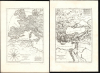
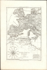
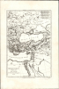
Imperii Romani Distracta Pars Occidentalis / Imperii Romani Distracta Pars Orientalis.
Roman Empire, Torn Apart.
- Digital Map Information
- Suitable for large format printing
- Full resolution TIFF file
- ICC color profile embedded
- Delivered instantly via download link
Roman Empire, Torn Apart.
This attractive map set comprises Rigobert Bonne's 1787 depiction of the dissolved Roman Empire in the early Middle Ages, reflecting the period of fragmentation sometimes referred to as the Dark Ages. These were among the historical maps included in Bonne and Nicolas Desmarest's Atlas Encyclopédique. They provided a reference to European history, presenting classical and post-classical placenames in a modern geographical framework. The maps are skillfully and elegantly engraved.A Closer Look
The western sheet displays Europe and North Africa as far west as the mouth of the Adriatic Sea; it reaches far enough north to encompass Denmark and southern Sweden, Ireland, and England (but not Scotland). The eastern sheet extends from Greece eastward to show the Lower Nile, the Red Sea, the Levant, and the Black Sea, and stretches north to include Riga and Moscow. The western sheet is embellished with a fine compass rose.The geographical framework used was based on modern cartographic knowledge; the placenames and borders were historical, reflecting 18th-century understanding of the period following the fall of the Roman Empire. Instead of the African Roman provinces of Mauritania Tingitana and Caesariensis, for example, the map illustrates the Kingdom of Fez, the Moroccan Empire, and the Kingdom of Al Gezairium (Algeria). The prominence of the Tunisian city of Cairvan (Kairouan, the first Islamic city in northwestern Africa) reflects the historical period from the 7th century to the city's destruction in the 11th century. Britain is shown as it was divided in the era of the Anglo-Saxon kings. The presence of both upper and lower Lotharingia in France and Germany would suggest that the map was intended to depict the region no earlier than the 10th century, following the partition of Lotharingia; the presence of Neustria in northern France suggests a date no later than the 10th century. In the eastern sheet, Ukraine and Kyiv are noted, as are the cities of Pereslavl and Poltava; this suggests some fuzzy dating on Bonne's part, since while the two former cities were prominent in 10th-century Kyivan Rus', Poltava is not chronicled until the 12th century. Moscow appears as well, despite its earliest historical mention also occurring in the 12th century.
Publication History and Census
These were produced by Rigobert Bonne for inclusion as plates 18 and 19 in Bonne and Nicolas Desmarest's Atlas Encyclopédique, a successful student atlas that went through several editions in the late 18th century. Three examples of the western sheet are listed in OCLC, as opposed to five of the eastern sheet; both appear on the market from time to time. The entire Atlas Encyclopédique is well represented in institutional collections.Cartographer
Rigobert Bonne (October 6, 1727 - September 2, 1794) was one of the most important French cartographers of the late 18th century. Bonne was born in Ardennes à Raucourt, France. He taught himself mathematics and by eighteen was a working engineer. During the War of the Austrian Succession (1740 - 1748), he served as a military engineer at Berg-op-Zoom. In the subsequent years, Bonne became one of the most respected masters of mathematics, physics, and geography in Paris. In 1773, Bonne succeeded Jacques-Nicolas Bellin as Royal Cartographer to France in the office of the Hydrographer at the Depôt de la Marine. Working in his official capacity, Bonne compiled some of the most detailed and accurate maps of the period, most on an equal-area projection known erroneously as the 'Bonne Projection.' Bonne's work represents an important step in the evolution of the cartographic ideology away from the decorative work of the 17th and early 18th century towards a more scientific and practical aesthetic. While mostly focusing on coastal regions, the work of Bonne is highly regarded for its detail, historical importance, and overall aesthetic appeal. Bonne died of edema in 1794, but his son Charles-Marie Rigobert Bonne continued to publish his work well after his death. Further Details...
Source
Bonne, Rigobert and Desmarest, N., Atlas encyclopédique contenant la géographie ancienne, et quelques cartes sur la géographie du moyen age, la geographie moderne, et les cartes relatives a la géographie physique, (Paris: Hotel de Thou) 1787.
Condition
Excellent with generous margins.
References
OCLC 643718696, 643720437.