This item has been sold, but you can get on the Waitlist to be notified if another example becomes available, or purchase a digital scan.
1840 Dower Map of Rome, Italy
Rome-dower-1840$97.50

Title
Rome.
1840 (undated) 9 x 11 in (22.86 x 27.94 cm) 1 : 24500
1840 (undated) 9 x 11 in (22.86 x 27.94 cm) 1 : 24500
Description
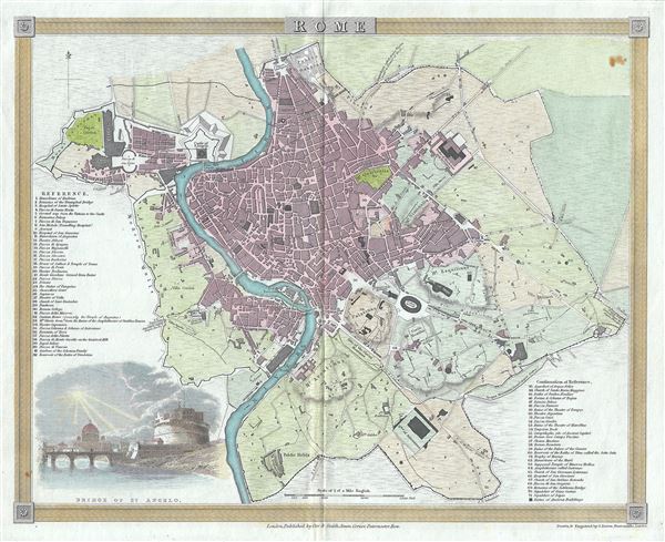
This is a beautiful 1840 map of the city of Rome, Italy by John Dower. It covers the walled center of Rome in incredible detail, reveling individual streets, parks, rivers, ancient ruins, and historic buildings. A list of important landmarks is referenced along the left and right margins, while a beautiful illustration of the Bridge of St. Angelo features in the lower left quadrant of the map.
This map heavily references, with various updates and revisions, the seminal 1734 map of Rome by Giovanni Battista Nolli. Nolli's map was the first modern map of Rome and basis of almost all subsequent maps of Rome until approximately 1870, when Rome became the capitol of Italy and more modern plans were issued. This map was drawn and engraved by John Dower and published by Orr and Smith in 1840.
This map heavily references, with various updates and revisions, the seminal 1734 map of Rome by Giovanni Battista Nolli. Nolli's map was the first modern map of Rome and basis of almost all subsequent maps of Rome until approximately 1870, when Rome became the capitol of Italy and more modern plans were issued. This map was drawn and engraved by John Dower and published by Orr and Smith in 1840.
Cartographer
John James Dower (June 1, 1825 - 1901) was a well-respected mapmaker, print seller, and publisher based in London, England. Dower is the heir to the more prominent London engraver and mapmaker John Crane Dower (1791 - 1847). Dower worked with many prominent middle to late 19th century London map publishers including Weller, Cassell, Bacon, Petermann, and others. He was elected to the Royal Geographical Society in 1854. Dower also published on maps his own account including one atlas and various school geographies. In addition to his cartographic work, Dower is well known as an engraver of military scenes. More by this mapmaker...
Condition
Very good. Original platemark visible. Slight wear along original centerfold. Minor foxing in top right quadrant.