This item has been sold, but you can get on the Waitlist to be notified if another example becomes available, or purchase a digital scan.
1945 Pictorial WWII Route Map of Europe: 89th Infantry Division
Route89thID-unknown-1945$350.00

Title
Route of the 89th. France - Luxembourg - Germany.
1945 (undated) 17.5 x 28 in (44.45 x 71.12 cm) 1 : 1500000
1945 (undated) 17.5 x 28 in (44.45 x 71.12 cm) 1 : 1500000
Description
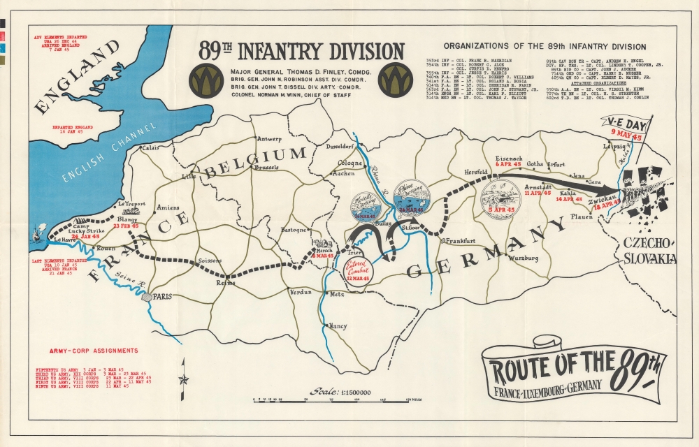
This is a 1945 World War II pictorial route map of Europe detailing the 89th Infantry Division's advance through France, Luxembourg, and Germany. Although not marked here, the 89th liberated Ohrdruf, a subcamp of the Buchenwald concentration camp, on April 4, 1945, making it the first Nazi concentration camp liberated by American soldiers.
A Closer Look
The map follows the 89th Infantry Division's route through Europe. The division reorganized in France in late January 1945 at Camp Lucky Strike after being inserted in at least two groups: the 'advance elements' that arrived in England on January 7, 1945, and the 'last elements' that arrived in France on January 21, 1945. From Camp Lucky Strike the division made its way across France, entering combat in Luxembourg on March 12. The division's crossing of the Moselle River (March 16) and the Rhine River (March 26) are marked by circular pictorial vignettes, as is combat near Eisenach, Germany. A column of POWs smashes a gigantic swastika in eastern Germany just below a flag proclaiming V-E (Victory in Europe) Day (May 9). The 89th's commanding officers are named at top center between two division insignia. Battalions and companies within the 89th are listed in the upper right. Red text in the lower left details changes to corps assignments from January through May.World War II Allied Route Maps
Maps tracing unit movements during World War II were created by both American and British forces during and after the war. As a genre, these maps represent a broad range of aesthetics, from the purely functional that label places and provide dates, to the artistic, even comic. Many combine the three and provide a visually striking but historically informative summary of the unit's peregrinations. The brutal reality of the war, however, was never very far away in any of these works.Publication History and Census
This map was created by an unknown artist (likely a member of the 89th) published by the 89th Infantry Division in 1945. We note four cataloged examples: United States Holocaust Memorial Museum, the Wisconsin Veterans Museum, and the University of Texas, the Controvich Library.Condition
Very good. Light wear along original fold lines.
References
United States Holocaust Memorial Museum 2019.294.9. OCLC 226216924.