This item has been sold, but you can get on the Waitlist to be notified if another example becomes available, or purchase a digital scan.
1851 Tallis / Rapkin Map of the Near East, Middle East, and India
RoutetoIndia-tallis-1851$87.50

Title
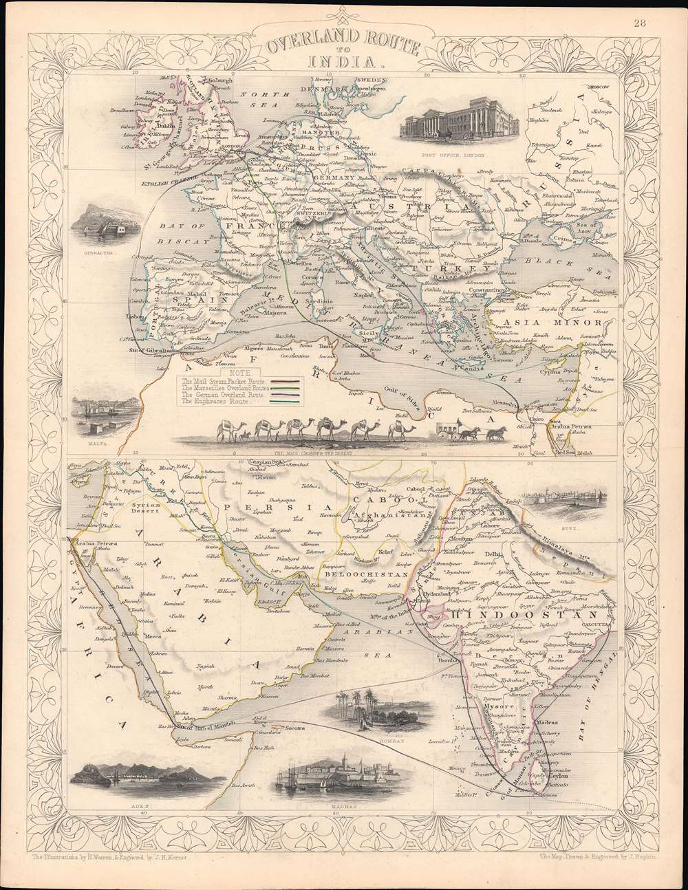
Overland Route to India.
1851 (undated) 14 x 10.5 in (35.56 x 26.67 cm) 1 : 34000000
1851 (undated) 14 x 10.5 in (35.56 x 26.67 cm) 1 : 34000000
Description
This is a rare 1851 John Rapkin / John Tallis map of the Near East, Middle East, and India, with hand-coloring of the overland routes to India and of national borders. The top portion shows the European section of four routes between London and India, while the bottom half shows the routes continuing through the Near and Middle East.
The escalating tensions led to several wars and proxy wars in India and Afghanistan, were connected with the Russian annexations of Khiva, Bukhara, and Kokand, and tied to wider geopolitical tensions between Russia and Britain, evident in the Crimean War and elsewhere. At the time this map was made, the British East India Company and its allies had just fought two wars to subjugate the Sikh Empire and a war to repel Persian influence in Afghanistan, which the British hoped to maintain as an independent buffer state between India and the Russian Empire.
Getting to India
This map shows four routes from London to India. Contrary to map's title, each route required a fair degree of sea travel. Though this map predates the Suez Canal, it also predates many of the earliest railways built in the Middle East, meaning that sea travel was the fastest route. One of the main motivations for such routes was communication, as suggested by the illustration of the Post Office in London and the route run by the Mail Steam Packet Company, a royal chartered shipping company that connected the British Empire, illustrated here in purple. At the time this map was made, a letter sent from London took weeks to reach India. While telegraph communications were a burgeoning industry, and networks existed within the British Isles and India, London and the Indian subcontinent would not be connected by telegraph until 1870.'The Great Game'
Though part of a world atlas, this map was made for an English-speaking audience in the context of the 'Great Game,' a diplomatic confrontation between the British and Russian Empires over territories in Central and Southern Asia. The conflict, rooted in long-standing animosity between Russia and Britain, revolved around Afghanistan, which, while lacking significant resources of its own, was strategically situated. For its part, Russia feared Britain was making commercial and military inroads into Central Asia, an area long within the sphere of influence of St. Petersburg. Britain, conversely, feared Russia making gains in India, 'the jewel in the crown' of British Asia.The escalating tensions led to several wars and proxy wars in India and Afghanistan, were connected with the Russian annexations of Khiva, Bukhara, and Kokand, and tied to wider geopolitical tensions between Russia and Britain, evident in the Crimean War and elsewhere. At the time this map was made, the British East India Company and its allies had just fought two wars to subjugate the Sikh Empire and a war to repel Persian influence in Afghanistan, which the British hoped to maintain as an independent buffer state between India and the Russian Empire.
Publication History
This map was part of the well-known Tallis's Illustrated Atlas and Modern History of the World published in 1851. It was drawn and engraved by John Rapkin and the illustrations were drawn by H. Warren and engraved by J.H. Kernot. This appears to be an atypical edition, as at bottom it says 'The London Printing and Publishing Company' rather than 'John Tallis and Company London and New York' as is generally the case.CartographerS
John Rapkin (July 18, 1813 - June 20, 1899) was an English mapmaker and engraver. Born in Southwark, Rapkin was the son of George Rapkin, a shoemaker, and his wife Elizabeth Harfy. Rapkin and his brother Richard both became engravers and his other brother, William Harfy Rapkin, became a copperplate printer. Rapkin produced works for James Wyld and John Tallis, including The United States and the relative position of Oregon and Texas for Wyld around 1845, and a series of eighty maps for Tallis that became 'Tallis's illustrated atlas, and modern history of the world' in 1851. Rapkin married Frances Wilmot Rudell on January 4, 1837, with whom he had at least eight children, some of whom became engravers, including his sons John Benjamin Rapkin (1837 - 1914), Alfred Thomas Rapkin (1841 - 1905), Joseph Clarke Rapkin (1846? - 1912), and Frederick William Rapkin (1859 - 1945). Rapkin operated under the imprint 'John Rapkin and Sons from 1867 until 1883, and was operating as 'John Rapkin and Sons' by 1887. Rapkin died in 1899 at the age of 85 soon after the death of his wife of over sixty years. More by this mapmaker...
John Tallis and Company (1838 - 1851) published views, maps, and atlases in London from roughly 1838 to 1851. Their principal works, expanding upon the earlier maps of John Cary and Aaron Arrowsmith, include an 1838 collection of London Street Views and the 1849 Illustrated Atlas of the World. The firm’s primary engraver was John Rapkin, whose name and decorative vignettes appear on most Tallis maps. Due to the embellishments typical of Rapkin's work, many regard Tallis maps as the last bastion of English decorative cartography in the 19th century. Although most Tallis maps were originally issued uncolored, it was not uncommon for 19th century libraries to commission colorists to "complete" the atlas. The London Printing and Publishing Company of London and New York bought the rights for many Tallis maps in 1850 and continued issuing his Illustrated Atlas of the World until the mid-1850s. Specific Tallis maps later appeared in innumerable mid to late-19th century publications as illustrations and appendices. Learn More...
John Tallis (November 7, 1817 - June 3, 1876) was an English map publisher and bookseller. Born in Stourbridge in Worcestershire, worked in his father's Birmingham agency from 1836 until 1842. Roughly in 1838, Tallis published a collection of London Street Views, and entered into a partnership with his brother Frederick Tallis from 1842 - 1849. Tallis and Company also published the Illustrated Atlas of the World in 1849. Also in 1849, Tallis traveled to New York City where he founded publishing agencies in six American cities. Upon returning from New York, Tallis paid his brother £10,000 for his share of the business, and operated from then on as John Tallis and Company until 1854. By 1853, John Tallis and Company had agencies in twenty-six cities in the United Kingdom, the United States, and Canada and employed over 500 people. By the end of 1853, Tallis had made the decision to share the burden of running such an extensive company and formed the London Printing and Publishing Company on February 24, 1854, becoming co-managing director with Ephraim Tipton Brain. After a series of setbacks, however, Tallis had to sell his estate and by 1861 was declared bankrupt. He was kept afloat by the kindness of friends and former employees, but none of his 'various ambitious projects' ever worked out for the rest of his life. Tallis married Jane Ball on December 6, 1836 in Birmingham, with whom he lived until her death in 1862. Tallis remarried on June 27, 1863 to Mary Stephens, with whom he had two children. Learn More...
Source
Tallis, J., The Illustrated Atlas, And Modern History Of The World Geographical, Political, Commercial and Statistical, (London and New York: Tallis) 1851.
Condition
Very good. Trace evidence of soiling along edges.