This item has been sold, but you can get on the Waitlist to be notified if another example becomes available, or purchase a digital scan.
1748 Vaugondy Map of Bohemia (Czech Republic), Moravia and Silesia
RoyaumeBoheme-vaugondy-1748$50.00

Title
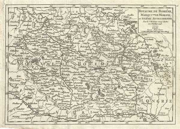
Royaume de Boheme, Marquisat de Moravie, et Silesie Autrichienne.
1748 (dated) 7 x 9.5 in (17.78 x 24.13 cm) 1 : 2300000
1748 (dated) 7 x 9.5 in (17.78 x 24.13 cm) 1 : 2300000
Description
This is a fine 1748 map of Bohemia, Moravia and Silesia by Robert de Vaugondy. It covers modern day Czech Republic as well as parts of Germany and Poland and extends from Leipzig, Germany east to Benthen, Poland and south as far as Passau. The entire region is depicted in extraordinary detailed, offering both topographical and political information, with forests and mountains beautifully rendered in profile.
The Province of Silesia was formed after King Frederick the Great of Prussia seized the region following the War of Austrian Succession and later became part of the German Empire in 1871. After World War II and the Potsdam Agreement, most of the province would become part of Prussia, while a small western portion of the province would be incorporated into the German states of Brandenburg and Saxony.
This map was published in the 1748 edition of Vaugondy's Atlas Portratif Universel et Militaire.
Cartographer
Robert de Vaugondy (fl. c. 1716 - 1786) was French may publishing from run by brothers Gilles (1688 - 1766) and Didier (c. 1723 - 1786) Robert de Vaugondy. They were map publishers, engravers, and cartographers active in Paris during the mid-18th century. The father and son team were the inheritors to the important Nicolas Sanson (1600 - 1667) cartographic firm whose stock supplied much of their initial material. Graduating from Sanson's maps, Gilles, and more particularly Didier, began to produce their own substantial corpus. The Vaugondys were well-respected for the detail and accuracy of their maps, for which they capitalized on the resources of 18th-century Paris to compile the most accurate and fantasy-free maps possible. The Vaugondys compiled each map based on their own geographic knowledge, scholarly research, journals of contemporary explorers and missionaries, and direct astronomical observation. Moreover, unlike many cartographers of this period, they took pains to reference their sources. Nevertheless, even in 18th-century Paris, geographical knowledge was limited - especially regarding those unexplored portions of the world, including the poles, the Pacific Northwest of America, and the interiors of Africa, Australia, and South America. In these areas, the Vaugondys, like their rivals De L'Isle and Buache, must be considered speculative or positivist geographers. Speculative geography was a genre of mapmaking that evolved in Europe, particularly Paris, in the middle to late 18th century. Cartographers in this genre would fill in unknown lands with theories based on their knowledge of cartography, personal geographical theories, and often dubious primary source material gathered by explorers. This approach, which attempted to use the known to validate the unknown, naturally engendered rivalries. Vaugondy's feuds with other cartographers, most specifically Phillipe Buache, resulted in numerous conflicting papers presented before the Academie des Sciences, of which both were members. The era of speculative cartography effectively ended with the late 18th-century explorations of Captain Cook, Jean Francois de Galaup de La Perouse, and George Vancouver. After Didier died, his maps were acquired by Jean-Baptiste Fortin, who in 1787 sold them to Charles-François Delamarche (1740 - 1817). While Delamarche prospered from the Vaugondy maps, he defrauded Vaugondy's window Marie Louise Rosalie Dangy of her rightful inheritance and may even have killed her. More by this mapmaker...
Source
Robert de Vaugondy, G., Atlas Portatif, Universel, et Militaire, (Paris: Vaugondy, Durand, Pissot) 1748.
Condition
Very good. Original platemark visible. Minor foxing.
References
Pedley, M. S., Bel et Utile, p. 181, 284.