This item has been sold, but you can get on the Waitlist to be notified if another example becomes available, or purchase a digital scan.
1701 De Fer Map of Sicily, Italy
RoyaumeDeSicile-defer-1701$100.00

Title
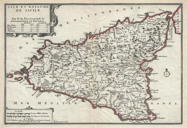
Isle et Royaume de Sicile.
1701 (dated) 9.5 x 13.5 in (24.13 x 34.29 cm) 1 : 900000
1701 (dated) 9.5 x 13.5 in (24.13 x 34.29 cm) 1 : 900000
Description
A beautiful 1701 map of Sicily, Italy by Nicholas De Fer. It covers the Mediterranean Island in its entirety and renders the region in extraordinary detail offering both topographical and political information with mountains beautifully rendered in profile. Mt. Etna, the tallest active volcano in the region, is beautifully rendered. Sicily became a Greek colony around 750 BC and according to Greek mythology, the monster Typhon, is trapped under Mount Etna. This map was engraved by Harmanus van Loon and created by Nicholas De Fer for his 1701 Atlas.
CartographerS
Nicholas de Fer (1646 - October 25, 1720) was a French cartographer and publisher, the son of cartographer Antoine de Fer. He apprenticed with the Paris engraver Louis Spirinx, producing his first map, of the Canal du Midi, at 23. When his father died in June of 1673 he took over the family engraving business and established himself on Quai de L'Horloge, Paris, as an engraver, cartographer, and map publisher. De Fer was a prolific cartographer with over 600 maps and atlases to his credit. De Fer's work, though replete with geographical errors, earned a large following because of its considerable decorative appeal. In the late 17th century, De Fer's fame culminated in his appointment as Geographe de le Dauphin, a position that offered him unprecedented access to the most up to date cartographic information. This was a partner position to another simultaneously held by the more scientific geographer Guillaume De L'Isle, Premier Geograph de Roi. Despite very different cartographic approaches, De L'Isle and De Fer seem to have stepped carefully around one another and were rarely publicly at odds. Upon his death of old age in 1720, Nicolas was succeeded by two of his sons-in-law, who also happened to be brothers, Guillaume Danet (who had married his daughter Marguerite-Geneviève De Fer), and Jacques-François Bénard (Besnard) Danet (husband of Marie-Anne De Fer), and their heirs, who continued to publish under the De Fer imprint until about 1760. It is of note that part of the De Fer legacy also passed to the engraver Remi Rircher, who married De Fer's third daughter, but Richer had little interest in the business and sold his share to the Danet brothers in 1721. More by this mapmaker...
Harmanus van Loon (fl. c. 1690 - c. 1725) was a Flemish engraver active in Paris during the late 17th and early 18th centuries. Van Loon worked primarily in Paris and often signed his work, which includes maps and other engravings for such prominent cartographers as Nicolas de Fer, Jean Baptiste Nolin, Guillaume Delisle, and others. There is some speculation that he may have been related to the Brussels born painter Theodorus van Loon. Learn More...
Source
Fer, Nicholas de, Cartes et Descriptions Generales et Particulieres pour l'intelligence des affaires du temps, au sujet de la Succession de la Couronne d'Espagne, en Europe, en Asie, Afrique, et Amerique, (Paris) 1701.
Condition
Very good. Minor wear along original fold lines. Original platemark visible.