This item has been sold, but you can get on the Waitlist to be notified if another example becomes available, or purchase a digital scan.
1780 Bowles Map of the North Atlantic, Pacific Northwest, and Siberia w/Proto-Alaska
RussianDiscoveries-bowles-1780-2$475.00

Title
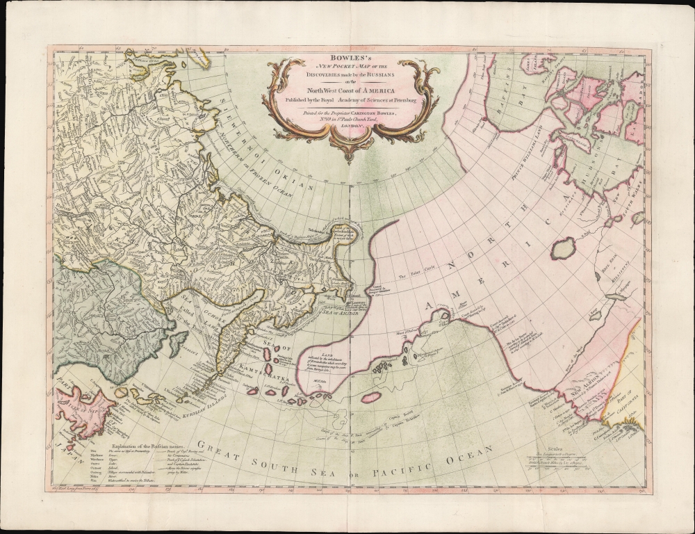
Bowles's New Pocket Map of the Discoveries made by the Russians on the North West Coast of America Published by the Royal Academy of Sciences at Petersburg.
1780 (undated) 19 x 25 in (48.26 x 63.5 cm) 1 : 16000000
1780 (undated) 19 x 25 in (48.26 x 63.5 cm) 1 : 16000000
Description
An attractive example of Carrington Bowles' 1780 map of the North Pacific, including parts of Alaska, the Pacific Northwest, and Northeast Asia. Most dramatically, the map includes a large speculative pre-Cook peninsula extending westward from North America toward Asia. This is generally known as the Muller Peninsula after Gerhard Muller, who hypothesized it in 1754. The map is also notable for its unusual bulbous promontory in northern Siberia, an interpretation of the Witsen Peninsula, which is a mismapping of the Chukchi Peninsula.
Following the Bering expedition, Joseph Nicholas de L'Isle, younger brother of the major French cartographer Guillaume de L'Isle, privately published (along with Buache) his interpretation of the Great Northern Expedition's discoveries. J. N. de L'Isle was employed by the St. Petersburg Royal Academy at the time, but upon his brother's death, quit the position and returned to Paris. He partnered with Nicholas Buache to publish a wildly speculative map of the Pacific Northwest that did much to popularize the mythical of the Sea of the West (not on present map).
The Russians believed that de L’Isle had improperly used information gathered while he was serving in the St. Petersburg Royal Academy. Moreover, they were aware of his incorrect delineation of the Northwest Coast of America and were offended that this referenced and demeaned their excellent academic reputation. Irritated by the publication, the St. Petersburg Academy of Sciences ordered Gerhard Muller to compile a more accurate map from the complete official accounts of the Great Northern Expedition. That resulted in a 1754 map that is the first to speculate a large peninsula extending westward from the American Pacific Northwest. That peninsula, a kind of Proto-Alaska, became known as Muller's Peninsula.
The map went through several issues, each with updates. The 1758 edition adds a route across the Mer D'Ochozk, but is otherwise largely unchanged from the 1754 edition. The first major revision appeared in 1773, when Jacob van Staehlin revisited the Muller map in light of new discoveries from 1764 onwards by Russian explorers (Ivan Synd) as well as Russian fur merchants (Promyshlenniki). Van Staehlin removed Muller's peninsula, replacing it with a series of small islands surrounding a larger island. Although still inaccurate, the archipelago is far closer to the Aleutians and the Alaskan mainland than any previous map.
All Muller maps and their derivatives do not include N. de L'Isle's mythical 'Sea of the West,' although he does continue to hold out hope for a water route from the Pacific Ocean to the Atlantic Ocean via tentatively located 'R. de l'Ouest' or 'River of the West' connecting the northern California coast to Hudson's Bay. Streeter notes that Muller's map confirmed the existence of a body of water between Asia and America, the subject of much dispute during the previous two hundred years. It also showed the Kuril Islands correctly and suggested the outline of Alaska and the Aleutian chain.
Dezhnev ultimately proved that there was indeed a nautical route from Arctic Siberia to East Asia, but at the same time confirmed that it was exceedingly impractical. On his one-year voyage, Dezhnev and his small fleet skirted the Siberian coast in rough conditions, recording only loosely what they saw, but nonetheless described several islands and two large peninsulas. His description of the promontory was subsequently embraced by other cartographers who, lacking serious scientific data from the Dezhnev expedition, surmised the form. Essentially, Witsen's peninsula is a mismapping of the existent Cape Shelagskiy, which Dezhnev rounded, located about 1000 west of the Bering Strait.
The first non-Russian to study this data was Dutchman Nicholaas Witsen, who prepared a map in 1687 based upon Dezhnev's records that he discovered on a 1665 trip to Moscow - hence 'Witsen's Peninsula' was introduced to western Europe. When European cartographers saw Witsen's map and begin to copy it, they did not know of Dezhnev's voyage or Witsen's sources so, by the mid-18th century, some speculated that this was not a peninsula, but a land bridge extending all the way to America.
Muller Map and Derivatives
The map upon which this is based, published in 1754, was the first official map to reflect the results of Vitus Bering's Great Northern Expedition. The Great Northern Expedition was one of the largest and best-organized voyages of exploration, the results of which remapped most of the Arctic coast of Siberia and some parts of the Northwest coast of America, filling in vast amounts of coastal detail, which previously had been the subject of myth and speculation. Originally conceived by Russian Emperor Peter I the Great, the exploration was undertaken under the auspices of Russian Empresses Anna and Elizabeth, under the direction of Vitus Bering. Lasting from 1733 - 1743, it was intended to map the eastern reaches of Siberia and the Northwest Coast of America. Its many accomplishments include the European discovery of Alaska, the Aleutian Islands, the Commander Islands, and Bering Island, as well as a detailed mapping of the northern and north-eastern coast of Russia and the Kuril Islands. The expedition formally ended the myth of a massive land mass in the North Pacific.Following the Bering expedition, Joseph Nicholas de L'Isle, younger brother of the major French cartographer Guillaume de L'Isle, privately published (along with Buache) his interpretation of the Great Northern Expedition's discoveries. J. N. de L'Isle was employed by the St. Petersburg Royal Academy at the time, but upon his brother's death, quit the position and returned to Paris. He partnered with Nicholas Buache to publish a wildly speculative map of the Pacific Northwest that did much to popularize the mythical of the Sea of the West (not on present map).
The Russians believed that de L’Isle had improperly used information gathered while he was serving in the St. Petersburg Royal Academy. Moreover, they were aware of his incorrect delineation of the Northwest Coast of America and were offended that this referenced and demeaned their excellent academic reputation. Irritated by the publication, the St. Petersburg Academy of Sciences ordered Gerhard Muller to compile a more accurate map from the complete official accounts of the Great Northern Expedition. That resulted in a 1754 map that is the first to speculate a large peninsula extending westward from the American Pacific Northwest. That peninsula, a kind of Proto-Alaska, became known as Muller's Peninsula.
The map went through several issues, each with updates. The 1758 edition adds a route across the Mer D'Ochozk, but is otherwise largely unchanged from the 1754 edition. The first major revision appeared in 1773, when Jacob van Staehlin revisited the Muller map in light of new discoveries from 1764 onwards by Russian explorers (Ivan Synd) as well as Russian fur merchants (Promyshlenniki). Van Staehlin removed Muller's peninsula, replacing it with a series of small islands surrounding a larger island. Although still inaccurate, the archipelago is far closer to the Aleutians and the Alaskan mainland than any previous map.
All Muller maps and their derivatives do not include N. de L'Isle's mythical 'Sea of the West,' although he does continue to hold out hope for a water route from the Pacific Ocean to the Atlantic Ocean via tentatively located 'R. de l'Ouest' or 'River of the West' connecting the northern California coast to Hudson's Bay. Streeter notes that Muller's map confirmed the existence of a body of water between Asia and America, the subject of much dispute during the previous two hundred years. It also showed the Kuril Islands correctly and suggested the outline of Alaska and the Aleutian chain.
The Dezhnev Anomaly or Witsen's Peninsula
Note the bulbous peninsula extending northeasterly from Siberia east of the Kolyma River and identified as 'Tschuktschi'. Today this semi-mythical peninsula is known as Witsen's Peninsula. Around 1648, the Cossack Semen Ivanovich Dezhnev (1605 - 1673) put together a rough and ready expedition to explore the waterways around northeastern Siberia. His company consisted of Fedot Alekseyev, traveling with the merchants Andreev and Afstaf'iev (representing the Guselnikov merchant house), who provided their own ship, and Gerasim Ankudinov, an experienced sea captain with his own ship and 30 men. Dezhnev, along with Mikhail Stadukhin, recruited 19 men of their own and procured a traditional kocha ship. Including escort vessels, a total seven ships sailed from the mouth the Kolyma River, along the Siberian Arctic, to the Anadyr River north of Kamchatka, and in doing so became the first Europeans to sail through the Bering Strait roughly 80 years before Vitus Bering. Dezhnev described rounding a large mountainous promontory identified as Chukchi, Tschuktschi, or Chukotka Peninsula. Of the seven vessels the multiple leaders, only three ships, including Dezhnev’s, survived the passage.Dezhnev ultimately proved that there was indeed a nautical route from Arctic Siberia to East Asia, but at the same time confirmed that it was exceedingly impractical. On his one-year voyage, Dezhnev and his small fleet skirted the Siberian coast in rough conditions, recording only loosely what they saw, but nonetheless described several islands and two large peninsulas. His description of the promontory was subsequently embraced by other cartographers who, lacking serious scientific data from the Dezhnev expedition, surmised the form. Essentially, Witsen's peninsula is a mismapping of the existent Cape Shelagskiy, which Dezhnev rounded, located about 1000 west of the Bering Strait.
The first non-Russian to study this data was Dutchman Nicholaas Witsen, who prepared a map in 1687 based upon Dezhnev's records that he discovered on a 1665 trip to Moscow - hence 'Witsen's Peninsula' was introduced to western Europe. When European cartographers saw Witsen's map and begin to copy it, they did not know of Dezhnev's voyage or Witsen's sources so, by the mid-18th century, some speculated that this was not a peninsula, but a land bridge extending all the way to America.
Publication History and Census
This map was published by Carrington Bowles c. 1780. Later examples were published by his heirs, Bowles and Carver, c. 1784. The map was also pirated by the Italian cartographers Santini and Remondini, who issued a version in 1784. It appears in both 'pocket' and folio atlas format.Cartographer
The Bowles Family (fl. c. 1714 - 1832) were publishers and map sellers active in London from c. 1714 to c. 1832. The firm, under Thomas Bowles (fl. 1714 - 1763), John Bowles (1701 - 1779), Carrington Bowles (1724 - 1793), and as Bowles and Carver (fl. 1794 - 1832), produced a massive corpus of work that included numerous atlases, pocket maps, and wall maps. The Bowles publishing tradition was kept alive for four generations, starting with Thomas Bowles, a print engraver active in the late 17th century. His son, Thomas Bowles II, produced the firm's first maps at St. Paul's Churchyard, London. Thomas's brother, John Bowles (a.k.a. 'Old John Bowles' or 'Black Horse Bowles'), was also an active publisher established at no. 13 Cornhill. He is credited as one of the first publishers of William Hogarth's works. There, John's son, Carrington Bowles, was introduced to the trade. Carrington took over the Cornhill bookshop and eventually merged it with his uncle's shop in St. Paul's Churchyard. On Carrington's 1793 death, the business was passed to his son Henry Carrington Bowles (1763 - 1830), who partnered with his father's former apprentice Samuel Carver (1756 - 1841), renaming the firm 'Bowles and Carver'. Under this imprint, the firm continued to publish maps and atlases until 1832. Henry Carrington Bowles died in 1830, but Samuel Carver, himself in advanced years and poor health, kept it going for another 2 years before closing the business. More by this mapmaker...
Condition
Very good. Some old creasing. Centerfold wear.
References
OCLC 82979387.