This item has been sold, but you can get on the Waitlist to be notified if another example becomes available, or purchase a digital scan.
1873 Beers Map of East Hampton and Sag Harbor, Long Island, New York
SagHarborEastHampton-beers-1873$200.00

Title
East Hampton, Suffolk Co. L.I. / Sag Harbor, Suffolk Co.
1873 (undated) 14.5 x 24 in (36.83 x 60.96 cm)
1873 (undated) 14.5 x 24 in (36.83 x 60.96 cm)
Description
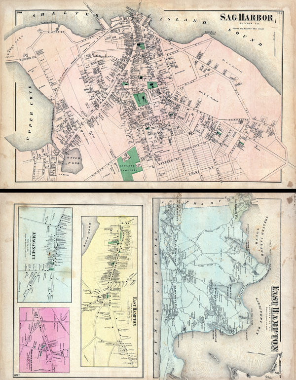
A scarce example of Fredrick W. Beers' map of the Sag Harbor and East Hampton, Long Island, New York. Published in 1873, this map is printed on both sides. On the Sag Harbor Side, this magnificent map covers the town of Sag Harbor in considerable detail from the Upper Cove to Shelter Island Sound. Details individual streets and properties. On the East Hampton side the sheet is divided into four maps detailed the general region of East Hampton from Wainscott and Sag Harbor eastwards past East Hampton, Amagansett to Gardiners Island and Napeague Harbor. Shows parts of Gardiners Island including the estate of S. B. Gardiner. Smaller maps detail the towns of East Hampton, Amagansett and Bridgehampton with notations for individual buildings and properties. This is probably the finest atlas map of Sag Harbor and East Hampton to appear in the 19th century. Prepared by Beers, Comstock & Cline out of their office at 36 Vesey Street, New York City, for inclusion in the first published atlas of Long Island, the 1873 issue of Atlas of Long Island, New York.
Cartographer
The Beers family (Fredrick, Silas, James and Daniel) (fl. c. 1850 - 1886), along with Charles and Augustus Warner, were prominent map publishers working from the 1850s to the late 1880s. Often publishing under the Warner & Beers designation, the combined firms produced a series of important state and county atlases and map of much of the northeastern United States. Many of their regional maps are among the most detailed and well laid out maps ever produced of their respective regions. Because Warner & Beers county maps were often detailed down to the individual homes and landowners, they have become highly sought after by general and family historians. In additional to producing maps of surpassing detail, Warner & Beers also maintained an earlier generation's attention to detail and quality while publishing in an era ever increasingly dominated by the low cost printing methods used by the publishing empires of Rand McNally and George Cram. More by this mapmaker...
Source
Atlas of Long Island, New York. From Recent Actual Surveys and Records Under the Superintendence of F. W. Beers. (1873 First Edition).
Condition
Very good condition. Original folds. Sag Harbor on one side, East Hampton on opposite side.
References
New York Public Library, Map Division, 1527359, 1527357, 1527358.