1904 Service Topographique Chantereau Heliotype Map of Saigon, Vietnam
Saigon-chantereau-1904$4,500.00


Title
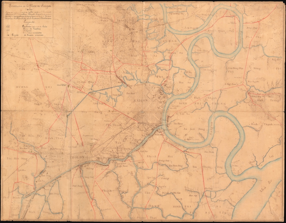
Environs de la Place de Saigon.
1904 (dated) 26 x 33.5 in (66.04 x 85.09 cm) 1 : 20000
1904 (dated) 26 x 33.5 in (66.04 x 85.09 cm) 1 : 20000
Description
An exceptional, highly detailed combination ferro-gallic and manuscript map of Saigon (Ho Chi Minh City), Vietnam, prepared in 1904 for Lieutenant Chantereau, an officer serving with the Artillerie Coloniale. The map captures Saigon at its peak as a colonial capital.
A Closer Look
The map is centered on the center of Saigon City, roughly corresponding to the modern District 1, west of the Song Sai Gon River between the Nhiêu Lộc River and the Bến Nghé River. It extends significantly into the surrounding regions, then dotted by small villages, pagodas, and markets, all of which are now part of metropolitan Ho Chi Minh City. The focus appears to be the network of roadways, railroads, tramways, and river connections between the trading center of Cholon (Chợ Lớn), then a separate city, and Saigon. Most of the text is either French or transliterated Vietnamese. City, town, village, and canton boundaries are delineated using various dotted lines referenced via a legend in the lower right. Pagodas are marked with a 'P'.A Unique Military Map
This is a unique piece. Ferro-gallic printing is a heliographic process (laying the original on light-sensitive paper and placing it under a strong light to transfer the image), suitable for field duplication of documents only in extremely small quantities (usually less than ten), underscoring the rarity of this map. Although the typography suggests it was heliotyped from a printed map, the present map has been extensively embellished by manuscript work in red and black ink, defining major roads, which often amounted to causeways in this swampy terrain. The map is clearly described as derived from a military survey completed by the French colonial army's Service Topographique during the campaigns of 1899 - 1900, with subsequent regularly filed updates. The updates may relate to the 1904 survey of Captains Sherdiin Benoît and Gros.French Cochinchina
French forces captured Saigon for Emperor Napoleon III in 1859, and the territory was formally ceded to France in 1862 by the Vietnamese Emperor Tự Đức (Tu Duc; 1829 - 1883). In the same year, Saigon was made capital of French Cochinchina, or South Vietnam, a large colony central to French colonial ambitions in Asia. In 1887, it became the capital of the greater Union of French Indochina. Unlike most French colonial cities, Saigon was French administered both de jure and de facto. The French lavished wealth on their new city. As the capital of Cochinchina, Saigon was transformed into a major port city and a metropolitan center, with beautiful villas, imposing public buildings, railroad infrastructure, and well-paved, tree-lined boulevards. By the late 19th century, Saigon was the principal port for rice and other goods from the Mekong Delta. Writing on a 1904 trip to Saigon, the anonymous Frenchwoman C. Vray, described the citySaïgon is the Paris of Cochinchina, it's the city of luxury and temptation, and how many, failing to resist, have foundered miserably in a whirlwind of pleasure? One spends too much money, one spreads one's wealth here. It's all about who spends the most and the best in this high society life where everything can be procured at a price.In 1902, the capital of the Indochinese Union was moved to Hanoi, but Saigon continued as the capital of Cochinchina, and as a center of trade, culture, and colonial life.
Ferro-Gallic Print
Ferro-Gallic printing, also called 'Iron Gall Print', is a photo-reproductive process developed in 1859 by Alphonse Louis Poitevin. The process became popular in the late 1880s when it was introduced commercially, particularly as it could be used to make fast copies of tracings and allowed for corrections to be made during the printing process. Moreover, copies could be made directly from originals without an intermediary negative process. Due to the chemicals used in this process, the background is never white; instead, it takes on a pale brown to lavender tint. Like most photo-reproductive processes of the period, ferro-gallic printing was useful only for short-run printing, usually of less than five copies, and impractical for mass production. Moreover, due to the photoreactive nature of the print and the low-quality field papers generally used, ferro-gallic prints rarely survive more than 30 years or so, making the early examples extremely scarce. The ferro-gallic process is similar to the Diazo Print or Whiteprint process, which replaced it in popularity in the early 20th century.Publication History and Census
This map is a ferro-gallic heliotype prepared in Saigon from the French Army's Service Topographique's general map of the region, now lost, surveyed roughly in 1900, and subsequently updated. The map features manuscript additions in red, blue, and brown/black. This particular heliotype was produced for Lieutenant Chantereau, an officer with the Artillerie Coloniale stationed in Saigon. We have been able to discover little of Chantereau, but there are limited references to him in several colonial reports, suggesting he spent at least three years in the region. As a custom map made for a single officer using a limited-run process, this is a unique piece.Cartographer
Service Géographique de l'Indochine (1899 - c. 1954) was created by decree on July 5, 1899. A Lieutenant Colonel Lubanski, from the Service Géographique de l'Armée, was put in charge. He along with several other army officers, as well as trained topographers and other geographers, immediately began applying the cutting-edge scientific practices employed by the Service Géographique de l'Armée in France to Indochina. They were tasked with creating detailed new maps of the colony. The Service Géographique immediately began mapping the Tonkin and Than-hoa deltas in extreme detail, and published annually a report on their progress. As for the rest of the country, which was sparsely populated and frequently inaccessible jungle, much less detailed maps were deemed sufficient. The Service Géographique also published an Atlas of Indochina annually from 1920 until at least 1932, as well as a summary of their work, which was published annually from 1900. Although the historical record is unclear, it is likely that the Service Géographique was disbanded during the Japanese occupation of Indochina during World War II and reconstituted after the Japanese defeat. During the 1950s the Service Géographique benefited from aerial photography. More by this mapmaker...
Condition
Good. Even overall toning. Some wear on original fold lines. Manuscript original color. Old heliotype printing naturally faded, with some manuscript overwriting.