This item has been sold, but you can get on the Waitlist to be notified if another example becomes available, or purchase a digital scan.
1715 De Fer Diagram of the Church of the Holy Sepulchre in Jerusalem
SaintSepulchre-defer-1715$375.00

Title
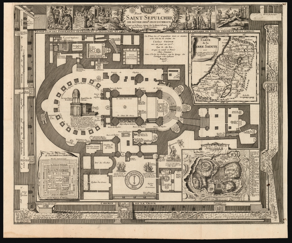
Plan du Saint Sepulchre de Notre Seigr. Jesus-Christ Situe en la Terre Sainte sur le Mont-Calvaire dans la Cite de Jerusalem from: Suite de l'Atlas Curieux.
1715 (dated) 15.5 x 19 in (39.37 x 48.26 cm)
1715 (dated) 15.5 x 19 in (39.37 x 48.26 cm)
Description
This is Nicolas De Fer's scarce, richly detailed 1715 plan of the Church of Holy Sepulchre, Jerusalem.
A Closer Look
At the center is a plan of the Church itself; its detail extends to refractories, sub-chapels, stairways, and individual shrines to apostles and saints. Inset plans include the Temple of Solomon, a map of the Holy Land, and a detailed plan of Jerusalem, reduced from that of Villalpando. It is abundantly illustrated. From the bottom left are vignettes depicting the stations of the cross, ending at the top with five vignettes showing the Crucifixion and the Resurrection. Within the engraving are vignettes of the burning of Christian martyrs, and a depiction of the interrupted sacrifice of Isaac.Church of the Holy Sepulchre
The Church of the Holy Sepulchre, located in the Christian Quarter of the Old City of Jerusalem, is one of the most revered sites in Christianity. Believed to be the site of both the crucifixion and the tomb of Jesus Christ, its origins date back to the 4th century when Emperor Constantine the Great ordered the construction of a church on the place where Jesus was believed to have been buried. Over centuries, the church has been destroyed and rebuilt several times, with the current structure featuring elements from various periods, reflecting a rich tapestry of Christian architectural styles. The church is a major pilgrimage destination, drawing visitors from around the world to its chapels, including the Hill of Calvary (Golgotha) and the Aedicule, which houses what is believed to be the tomb of Jesus. The site is jointly managed by several Christian denominations, including the Greek Orthodox, Armenian Apostolic, and Roman Catholic Churches, under a complex status quo arrangement. This coexistence, sometimes marked by tense relations, mirrors the broader religious and cultural complexities of the Holy Land.Publication History and Census
The map was engraved by De Fer in 1715 as an appendix inclusion to his L'Atlas Curieux. It is scarce. We see only five examples in OCLC, and it is rare to the market.CartographerS
Nicholas de Fer (1646 - October 25, 1720) was a French cartographer and publisher, the son of cartographer Antoine de Fer. He apprenticed with the Paris engraver Louis Spirinx, producing his first map, of the Canal du Midi, at 23. When his father died in June of 1673 he took over the family engraving business and established himself on Quai de L'Horloge, Paris, as an engraver, cartographer, and map publisher. De Fer was a prolific cartographer with over 600 maps and atlases to his credit. De Fer's work, though replete with geographical errors, earned a large following because of its considerable decorative appeal. In the late 17th century, De Fer's fame culminated in his appointment as Geographe de le Dauphin, a position that offered him unprecedented access to the most up to date cartographic information. This was a partner position to another simultaneously held by the more scientific geographer Guillaume De L'Isle, Premier Geograph de Roi. Despite very different cartographic approaches, De L'Isle and De Fer seem to have stepped carefully around one another and were rarely publicly at odds. Upon his death of old age in 1720, Nicolas was succeeded by two of his sons-in-law, who also happened to be brothers, Guillaume Danet (who had married his daughter Marguerite-Geneviève De Fer), and Jacques-François Bénard (Besnard) Danet (husband of Marie-Anne De Fer), and their heirs, who continued to publish under the De Fer imprint until about 1760. It is of note that part of the De Fer legacy also passed to the engraver Remi Rircher, who married De Fer's third daughter, but Richer had little interest in the business and sold his share to the Danet brothers in 1721. More by this mapmaker...
Juan Batista Villalpando (1552 - May 22, 1608) was a Spanish priest born to a Serphardic family, a scholar, mathematician, architect, and a member of the Jesuits. He was born in Cordoba; very little is known of his early life and education. He joined the Jesuits in 1575, for whom he served primarily as an architect. (He had studied the field with Juan de Herrera, Philip II's architect.) During his time he designed a number of buildings, including the Cathedral in Baeza. After his ordination, however, he focused on a study of the exegesis of the Old Testament. In 1596 he completed Jerónimo del Prado's commentaries on Ezekiel (this work brought him under suspicion of heresy, but he was found innocent.) Among his works on Ezekiel were reconstructions both of Solomon's Temple and Jerusalem overall, which caught the eye of many mapmakers and illustrators and stayed in circulation for centuries. His depictions were in no way archaeological or based even on contemporary visit, but were based on his interpretation of Biblical text following the assumption that the buildings were drawn according to geometrical law, and based on divine order. Learn More...
Condition
Excellent. Margin reinstated at insertion point. Top margin close but border complete.
References
OCLC 1176593164. Laor, E., Maps of the Holy Land: Cartobibliography of Printed Maps, 1475 - 1900, #1148.