This item has been sold, but you can get on the Waitlist to be notified if another example becomes available, or purchase a digital scan.
1775 Mannevillette Nautical Chart or Map of Selangor (Kuala Lumpur area) , Malaysia
Salangor-mannevillette-1775$275.00

Title
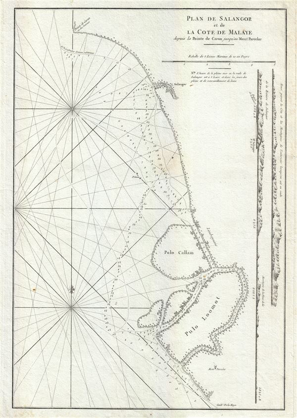
Plan de Salangor et de La Cote de Malaye depuis al Pointe de Caran jusqu au Mont Parcelar.
1775 (undated) 20 x 14 in (50.8 x 35.56 cm) 1 : 43744
1775 (undated) 20 x 14 in (50.8 x 35.56 cm) 1 : 43744
Description
A scarce 1775 map of the coasts of Malay (modern day Malaysia) in the vicinity of Kuala Lumpur. This is a fine example Jean-Baptiste d'Apres de Mannevillette 1775 nautical chart or maritime map of Selangor and the Strait of Malacca on the western coast of Malaysia. Mannevillette's map covers from Point Caran (Peken Tanjong Karang) to Parcelar Hill (Banting), including the Islands of Poolo Colong, Colong or Cal, and Poola Loomaut (known by their modern day names of Pulau Ketam, Pulau Klang and Pulau Lumut). Along the right border, two coastal profile views details the approaches to Selangor. Kuala Selangor, a town and the capital of modern day Selangor, was a Dutch trading center from about 1784 though the British East India Company would soon rise to dominate the Malay Peninsula. Though Kuala Lumpur, the modern capital of Malaysia, had not yet been founded, this is one of the few early maps to highlight this area, including the coastlands that would eventual be developed into Port Klang and Kelang.
The map offers rich detail including countless depth soundings, notes on the sea floor, commentary on reefs, rhumb lines, shoals, place names and a wealth of other practical information for the mariner. This chart was drawn by Jean-Baptiste d'Apres de Mannevillette and engraved by Guillaume-Nicolas Delahaye for publication in the 1775 Neptune Oriental.
The map offers rich detail including countless depth soundings, notes on the sea floor, commentary on reefs, rhumb lines, shoals, place names and a wealth of other practical information for the mariner. This chart was drawn by Jean-Baptiste d'Apres de Mannevillette and engraved by Guillaume-Nicolas Delahaye for publication in the 1775 Neptune Oriental.
CartographerS
Server Error
404
Page Not Found
This page either doesn't exist, or it moved somewhere else.
That's what you can do
Server Error
404
Page Not Found
This page either doesn't exist, or it moved somewhere else.
That's what you can do
Source
Mannevillette, Jean-Baptiste d'Apres de, Le Neptune Oriental, (Paris) 1775.
Condition
Very good. Some margin damage. Else clean.