This item has been sold, but you can get on the Waitlist to be notified if another example becomes available, or purchase a digital scan.
1796 Laurie and Whittle Nautical Chart or Map of Selangor (Kuala Lumpur area) , Malaysia
SalangorMalay-lauriewhittle-1796$375.00

Title
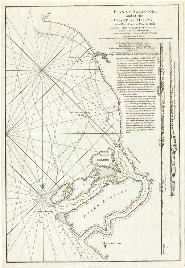
Plan of Salangor, and of the Coast of Malaya, from Point Caran to Paracelar Hill, including the Straits of Colong.
1796 (dated) 20 x 14 in (50.8 x 35.56 cm) 1 : 43744
1796 (dated) 20 x 14 in (50.8 x 35.56 cm) 1 : 43744
Description
A scarce 1796 map of the coasts of Malay (modern day Malaysia) in the vicinity of Kuala Lumpur, this is a fine example of Laurie and Whittle's 1796 nautical chart or maritime map of Selangor and the Strait of Malacca on the western coast of Malaysia. Laurie and Whittle's map covers from Point Caran (Peken Tanjong Karang) to Parcelar Hill (Banting), including the Islands of Poolo Colong, Colong or Cal, and Poola Loomaut (known by their modern day names of Pulau Ketam, Pulau Klang and Pulau Lumut). Along the right border, two coastal profile views details the Road of Selangor. An extensive annotation below the title offers detailed sailing instructions for the Strait of Colong (Sungai Tiga). Kuala Selangor, a town and the capital of modern day Selangor, was a Dutch trading center from about 1784 though the British East India Company would soon rise to dominate the Malay Peninsula. Though Kuala Lumpur, the modern capital of Malaysia, had not yet been founded, this is one of the few early maps to highlight this area, including the coastlands that would eventual be developed into Port Klang and Kelang.
The map offers rich detail including countless depth soundings, notes on the sea floor, commentary on reefs, rhumb lines, shoals, place names and a wealth of other practical information for the mariner. This chart was originally drawn by Jean-Baptiste d'Apres de Mannevillette and later corrected and improved from an English draught. This map was published by Laurie and Whittle from their offices at 53 Fleet Street, London, on March 1, 1796.
The map offers rich detail including countless depth soundings, notes on the sea floor, commentary on reefs, rhumb lines, shoals, place names and a wealth of other practical information for the mariner. This chart was originally drawn by Jean-Baptiste d'Apres de Mannevillette and later corrected and improved from an English draught. This map was published by Laurie and Whittle from their offices at 53 Fleet Street, London, on March 1, 1796.
Cartographer
Laurie and Whittle (fl. 1794 - 1858) were London, England, based map and atlas publishers active in the late 18th and early 19th century. Generally considered to be the successors to the Robert Sayer firm, Laurie and Whittle was founded by Robert Laurie (c. 1755 - 1836) and James Whittle (1757-1818). Robert Laurie was a skilled mezzotint engraver and is known to have worked with Robert Sayer on numerous projects. James Whittle was a well-known London socialite and print seller whose Fleet Street shop was a popular haunt for intellectual luminaries. The partnership began taking over the general management of Sayer's firm around 1787; however, they did not alter the Sayer imprint until after Sayer's death in 1794. Apparently Laurie did most of the work in managing the firm and hence his name appeared first in the "Laurie and Whittle" imprint. Together Laurie and Whittle published numerous maps and atlases, often bringing in other important cartographers of the day, including Kitchin, Faden, Jefferys and others to update and modify their existing Sayer plates. Robert Laurie retired in 1812, leaving the day to day management of the firm to his son, Richard Holmes Laurie (1777 - 1858). Under R. H. Laurie and James Whittle, the firm renamed itself "Whittle and Laurie". Whittle himself died six years later in 1818, and thereafter the firm continued under the imprint of "R. H. Laurie". After R. H. Laurie's death the publishing house and its printing stock came under control of Alexander George Findlay, who had long been associated with Laurie and Whittle. Since, Laurie and Whittle has passed through numerous permeations, with part of the firm still extant as an English publisher of maritime or nautical charts, 'Imray, Laurie, Norie and Wilson Ltd.' The firm remains the oldest surviving chart publisher in Europe. More by this mapmaker...
Source
Laurie, R., and Whittle, J., The East-India Pilot, or Oriental Navigator, on One Hundred and Eighteen Plates: Containing a Complete Collection of Charts and Plans, &c., &c. for the Navigation not only of the Indian and China Seas, but of those also between England and the Cape of Good-Hope; Improved and Chiefly Composed from the Last Work of M. D'Apres de Mannevillette; with Considerable Additions, from Private Manuscripts of the Dutch, and from Draughts and Actual Surveys Communicated By Officers of the East-India Company A New Edition, Containing One Hundred and Five Charts. (London: Laurie and Whittle) 1797.
Condition
Very good. Original platemark visible. Minor Foxing.