1909 Clason City Plan or Map of Salt Lake City, Utah
SaltLakeCity-clason-1909$400.00

Title
Map of Salt Lake City Utah.
1909 (dated) 18 x 22 in (45.72 x 55.88 cm) 1 : 19200
1909 (dated) 18 x 22 in (45.72 x 55.88 cm) 1 : 19200
Description
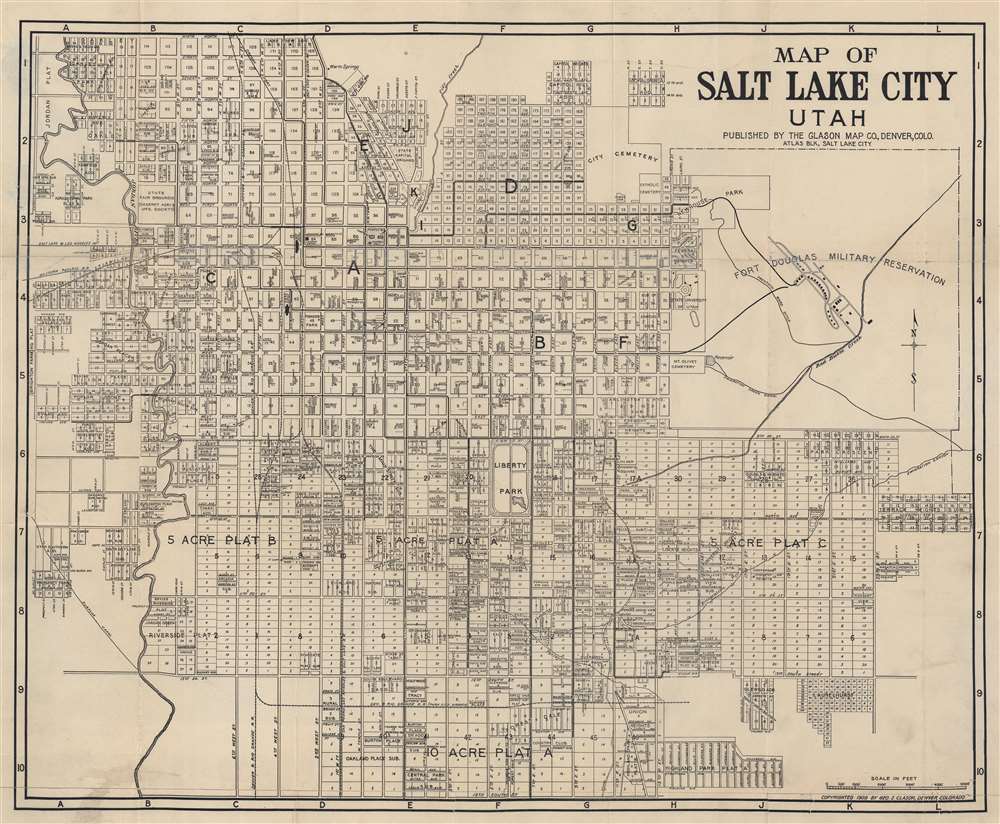
This is a 1909 Clason Map Company city plan or map of Salt Lake City, Utah. The Temple Block, situated in the upper left, is labeled and the Temple, Tabernacle, and Assembly Hall are illustrated and labeled as well. Streets and city blocks are identified, along with the post office, Liberty Park, the State University of Utah (today's University of Utah), and the State Capital Grounds. Fort Douglas Military Reservation dominates the upper right quadrant with Newhouse Park just outside its boundaries. The City Cemetery, Hebrew Cemetery, Catholic Cemetery, and Mt. Olivet Cemetery are all labeled as well.
Publication History and Census
This map was created and published by the Clason Map Company in 1909. We have located no other cataloged examples of the 1909 edition of this map.Cartographer
George Samuel Clason (November 7, 1874 - 1957) was born in the city of Louisiana, Missouri in 1874. As a young man, Clason studied at the University of Nebraska before joining the United States Army in 1898 to fight in the Spanish American War. After the war, he moved to Denver, Colorado where in 1905 he founded the Clason Map Company, thus starting his lucrative publishing career. Clason initially focused on mining and mineral maps - capitalizing on the Colorado and Nevada mining industry, but quickly transitioned to railroad maps, city maps, and by the 1920s, road maps. As the company expanded, Clason opened a secondary office in Chicago, Illinois - then a rising map publishing center and railroad hub. At least one other satellite office was opened in Los Angeles. Among his many achievements, Clason is credited with producing the first modern road atlas of the United States. In the late 1920s, Clason also published a series of get-rich-quick pamphlets in the form of parables. The most famous of these is The Richest Man in Babylon. This tells the story of Arkad, a citizen of Babylon famed for his great wealth and generosity who shares his wit and wisdom with his fellow Babylonians. In 1949, Clason moved to Napa, California to retire and found a social club for retired gentlemen. More by this mapmaker...
Condition
Good. Wear along original fold lines. Verso repairs to fold separations and at fold intersections. Slight loss at some fold intersections.