This item has been sold, but you can get on the Waitlist to be notified if another example becomes available, or purchase a digital scan.
1889 W. H. Whitney / Simon F. Mackie Map of Salt Lake City, Utah
SaltLakeCity-whitney-1889$2,500.00

Title
Salt Lake City, Utah.
1889 (dated) 22 x 26 in (55.88 x 66.04 cm) 1 : 22500
1889 (dated) 22 x 26 in (55.88 x 66.04 cm) 1 : 22500
Description
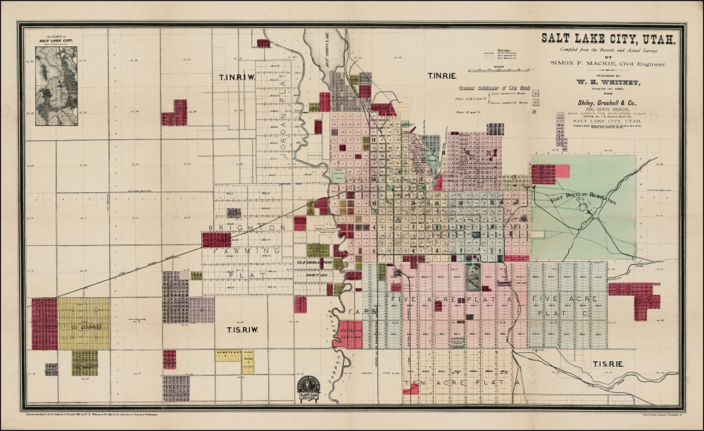
This is the rare 1889 W. H. Whitney and Simon F. Mackie map of Salt Lake City, Utah. The map illustrates the early days of Salt Lake City as a stop on the Rio Grande Western Railway. This is one of Whitney's earliest maps of western cities, predating his contract with the Union Pacific. It combines the functions of a real estate map and a railroad map. An inset in the upper left offers an overview of the general area.
In the 1880s a Utah division spun off, building a narrow gage line to connect Salt Lake City with Grand Junction. In 1888, to raise money for upgrades, Palmer incorporated the Salt Lake - Ogden like as a new railroad, the Rio Grande Western. Since narrow gage tracks were laid in the early 1880s, the main goal was to widen the gage to connect more seamlessly with the existing DRG network. Funds raids, the RGW was consolidated with the DRG in 1889. Construction between November 1889 and June 1890 completed the upgrade.
These lines and others under the DRG banner fell into the hands of railroad tycoon George Jay Gould (1864 - 1923) in 1900-1901. Under Gould they formed the foundation of a transcontinental route, the Western Pacific. Conflict with the Union Pacific eventually pushed the railroad into financial hardship, but it nonetheless continued to operate through the 20th century. In 1996 it was finally acquired by the Union Pacific and remains in operation.
A Closer Look
The map documents the development of Salt Lake City since its founding forty years prior. At this point, most development is confined to the east bank of the Jordan River. The city is platted into blocks and building lots noted, as well as public parks, Temple Block, Warm Springs Bath House, Fort Douglas Reservation, race track, penitentiary, etc.Denver Rio Grande Railroad
The Denver Rio Grande (DRG) was founded in 1870 by William Jackson Palmer (1836 - 1909). The proposed route was to proceed south from Denver an estimated 875 miles (1,408 km) to El Paso via Pueblo, the west along the Arkansas River, then through the San Luis Valley of Colorado toward the Rio Grande. Construction began in earnest, leading to a rivalry with the Atchison, Topeka and Santa Fe Railway. Legal arguments turned into the wild west style Colorado Railroad War (1877 - 1880), with both sides leveraging corrupt politicians and gangs of gunslingers to defend their claims. Federal courts decided on behalf of the Denver and Rio Grande, ending the war between the railroads, although the entrenched gunslingers in Pueblo (Bat Masterson and his gang), continued to fight, well, everyone.In the 1880s a Utah division spun off, building a narrow gage line to connect Salt Lake City with Grand Junction. In 1888, to raise money for upgrades, Palmer incorporated the Salt Lake - Ogden like as a new railroad, the Rio Grande Western. Since narrow gage tracks were laid in the early 1880s, the main goal was to widen the gage to connect more seamlessly with the existing DRG network. Funds raids, the RGW was consolidated with the DRG in 1889. Construction between November 1889 and June 1890 completed the upgrade.
These lines and others under the DRG banner fell into the hands of railroad tycoon George Jay Gould (1864 - 1923) in 1900-1901. Under Gould they formed the foundation of a transcontinental route, the Western Pacific. Conflict with the Union Pacific eventually pushed the railroad into financial hardship, but it nonetheless continued to operate through the 20th century. In 1996 it was finally acquired by the Union Pacific and remains in operation.
W. H. Whitney Maps
Between 1889 and 1890, W. H. Whitney issued a series of separate-issue large-scale pocket maps of western cities serviced by the first the Denver Rio Grande, then the Rio Grande Western, then, the Union Pacific and Northern Pacific Railroads. These include Salt Lake City, Portland, Seattle, Astoria, Spokane, Port Townsend, Bellingham Bay, and Tacoma. There are potentially others. They are the work of various surveyors, civil engineers, military surveyors, railroad engineers, and local land offices, compiled locally then sent to Philadelphia for engraving and printing. Most were engraved by Louis Humphrey Everts, some in partnership with 'Howell', as 'Everts and Howell'. The maps universally bear the distinctive logos of either the Rio Grande Western or the Union Pacific 'Overland Route', suggesting that the railroads at least partially financed their production. They were further designed to bear local advertising, which varies from example to example. The maps also, universally, bear the copyright of 'W. H. Whitney', filed in Washington D.C. While we cannot be certain, we believe this may be the Boston civil engineer William Henry Whitney, who, after 1888, owned a private civil engineering, surveying, and mapmaking firm in Boston. While Whitney may not have considered the maps important, they are today one of his most significant legacies. Individually and collectively, they represent some of the earliest obtainable maps of their respective subjects, marking them as important historical records of the urbanization of the Pacific Northwest. Today, all such maps are extremely scarce.Publication History and Census
The map was compiled by the civil engineer Simon F. Mackie and published in 1889 by W. H. Whitney on behalf of the Rio Grande Western Railway. It was printed in Philadelphia by Louis Humphrey Everts, as 'Everts and Howell'. This is one of just 3 maps Whitney issued for the Denver Rio Grande Western Railway, the others being of Trinidad and Pueblo, Colorado, dated 1888. Rare by all accounts. OCLC notes an example at Brigham Young University. We are aware of an additional example at the Library of Congress, and two instances of the map on the private market in the last 30 years.Cartographer
William Henry Whitney (January 3, 1843 - May 4, 1909) was an American civil engineer active in Boston in the second half of the 19th century. Whitney was born in Needham, Massachusetts. He studied at Cambridge High School then at the Lawrence Scientific School of Harvard University. In July of 1862, he enlisted in the Union Army to fight in the American Civil War (1861 - 1865). He served honorably throughout the war, seeing action and suffering wounds twice. He left the service with the rank of Brevet-Major. He served as Alderman of Cambridge. and was involved with the Back Bay development project - producing multiple maps and plans. He began his studies as a civil engineer before the war in the office of Stephen P. Fuller. From 1869 - 1871 he worked in the Boston City Engineer's Office and was involved with the Back Bay development project - producing multiple maps and plans. In 1872, he entered into partnership with J. Franklin Fuller, son of S. P. Fuller. After a short time, Fuller retired and Whitney took full control of the firm, in 1888 renaming it William H. Whitney. As a private contractor he continued to work on the Back Bay. Also around this time, he completed multiple plans for the official records of the Civil War. Between 1889 and 1890, he took a contract with the Union Pacific to produce a series of maps of western cities, including Portland, Salt Lake City, Seattle, Astoria, Port Townsend, Spokane, and more. While he did not consider them an important part of his corpus, they are today arguably his most significant works, being among the earliest obtainable plans of those cities. He was also influential in introducing blueprint technology to American architecture and engineering. More by this mapmaker...
Louis Humphrey Everts (April 14, 1836 - January 26, 1924) was an American map and atlas publisher active in the late 18th and early 19th century. Self-described as a "very busy and successful man", Everts was born in East Otto, New York. His family relocated to Geneva Illinois in 1851 where he worked as a clerk. In 1860 he moved to Chicago where he worked in Potter Palmer's dry-goods establishment. Following the outbreak of the America Civil War Everts joined the Union Army accepting a commission as Second Lieutenant in Company D. In 1861 he was promoted to First Lieutenant. During the course of the Civil War Everts saw action at Shiloh and Corinth before becoming an aide-de-camp to General Pleasant Adams Hackleman. He was later promoted again to the rank of Captain serving in the Western Theater and participating in Sherman's March. He ended his military service in 1865 with the rank of Brevet Major. During the war Everts befriend trade cartographer Thomas Hinckley Thompson, also a captain. Planning military strategy revealed the notable dearth of high quality county plans. Seeing a business opportunity the two teamed up as 'Everts and Thompson' (1865 - 1872) and began publishing county maps in Chicago. After the Great Chicago Fire, Everts acquired Thompson's stock and, in his own words "made the business large and profitable until it was necessary for me to visit Philadelphia and establish an office". Everts expanded his production rapidly moving away from standalone maps and refocusing on town histories and county atlases. He worked with numerous partners and seems to have been profitable, investing widely and diversely from land speculation to insurance firms. Apparently he was not the most successful investor and was forced to declare bankruptcy in 1900. Within two years he was back at head of a new firm, the Century Map Company. Active from 1902 to 1912 the Century Map Company published twelve atlases. Everts retired in 1913 and after briefly residing in a home for retired veterans moved to 215 Green Street, Philadelphia, where he lived until his death at 87 years. Learn More...
Condition
Very good.
References
Moffat, R. M., Printed Maps of Utah to 1900: An Annotated Cartobibliography, #227. Phillips, America, p. 773.