This item has been sold, but you can get on the Waitlist to be notified if another example becomes available, or purchase a digital scan.
1855 U. S. War Department Map of Salt Lake City, Utah to San Francisco Bay, California
SaltlakeCitySanFrancisco-topoengin-1855$325.00

Title
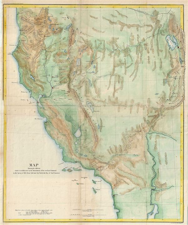
Map Showing the different routes travelled over by the Detachments of the overland Command in the Spring of 1855 from Salt Lake City, Utah to the Bay of San Francisco.
1855 (dated) 23 x 19.5 in (58.42 x 49.53 cm)
1855 (dated) 23 x 19.5 in (58.42 x 49.53 cm)
Description
This is a beautiful example of the 1855 War Department map of Salt Lake City, Utah to San Francisco Bay, California. The map covers the Great Basin to illustrate the routes traveled by Colonel e. J. Steptoe, Captain Rufus Ingalls and Lieutenant Sylvester Mowry from Utah to California in order to find a new and shorter route from the Great Salt Lake to the Pacific Coast. It covers all of California from San Diego to the Siskiyou Mountains and from Pacific Coast east as far as the Wasatch Range and the Great Salt Lake. Several forts, lakes, rivers, cities, creeks, mountains and various other topographical details are marked. The routes by the tree detachments, led by Steptoe, Ingalls and Mowry and camping grounds are noted. engraved by Ackerman of 379, Broadway, New York.
Cartographer
Army Corps of Topographical Engineers (fl.1838 - 1863) refers to the an elite branch of the U.S. Army created on July 4, 1838 to perform civil mapping and survey work throughout the United States. The origins of the Corps of Topographical Engineers can be traced back to the American Revolutionary War, where General George Washington recognized the need for accurate surveys pursuant to military action. Shortly following the war, in 1779, a civilian engineering corps was created by act of Congress. Identified in 1802 by Thomas Jefferson, the "Corps of Engineers," which was based at West Point, the group participated in the War of 1812 and in later in the fortification of New Orleans. It was not until 1838, however, that a separate group of "Topographical Engineers" was formally recognized. This elite group, consisting only of officers, most of whom were trained in surveying and engineering by the esteemed Andrew Ellicott at West Point, never numbered more than 36 individuals - the best and brightest. This small but determined group played a central role in the mapping and exploration of the American West. Few branches of the military can boast such a distinguished alumni. Their names resonate throughout the map of the west and include John Charles Fremont, Zebulon Pike, George Meade, Kemble Warren, William Amiel Weeks, A. B. Gray, Randolph B. Marcy, James H. Simpson, Howard Stansbury, John W. Gunnison, William Ludlow, and Robert S. Williamson. The onset of the American Civil War brought an abrupt end to the surveying activity of the Topographical Engineers. Many of the most prominent engineers went on to distinguished military careers on both sides of the War Between the States. The Army Corps of Topographical Engineers itself was folded into the Corps of Engineers on March 31, 1863. Though the Army Corps of Engineers continues to do military and civil survey work to this day, the elite club of adventures that formed the Topographical Engineers were no more. More by this mapmaker...
Condition
Very good. Original fold lines visible. Left margin extended. Typical wear along folds. Professionally flattened and backed with archival tissue.
References
Wagner, H., and Camp, C. L., The Plains & the Rockies: A Critical Bibliography of Exploration, Adventure, and Travel in the American West, 1800-1865, 256. Wheat, Carl Irving, Mapping of the Transmississippi West, 1540-1861, 868.