This item has been sold, but you can get on the Waitlist to be notified if another example becomes available, or purchase a digital scan.
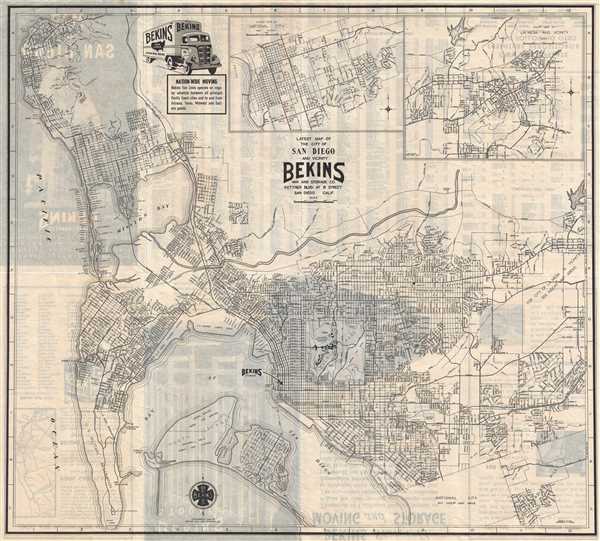
1940 Bekins City Map or Plan of San Diego, California
SanDiego-bekins-1940$125.00

Title
Latest Map of the City of San Diego and Vicinity.
1940 (dated) 17.25 x 19 in (43.815 x 48.26 cm) 1 : 50745
1940 (dated) 17.25 x 19 in (43.815 x 48.26 cm) 1 : 50745
Description
This is a 1940 Bekins Van and Storage Company city map or plan of San Diego, California. The map depicts the city of San Diego from the Pacific Ocean to La Mesa and Paradise Hills and from La Jolla Bay to Coronado and National City. Highly detailed, individual streets are labeled across the city, including smaller streets in neighborhoods. Balboa Park is featured and the zoological gardens, the Plaza Panama, and the California Pacific International Exposition are labeled within the park. Mission Bay and Mission Beach are both labeled. Several military bases are also labeled around San Diego, as the Battle Fleet was based there until the summer of 1940, when it was instructed to take up an 'advanced' position at Pearl Harbor, Hawaii. The Pacific Fleet was not recreated until February 1, 1941. These military installations include a U.S. Marine Corps Base and a U.S. Naval Training Station along San Diego Bay and a United States Naval Air Station and Rockwell Field Army Air Station on North Island. A Bekins Storage location is marked in large block letters, along with a proposed new Bekins branch.
This map was published by the Bekins Van and Storage Company in 1940. Benkins also issued similar maps of San Francisco and Los Angeles.
This map was published by the Bekins Van and Storage Company in 1940. Benkins also issued similar maps of San Francisco and Los Angeles.
Condition
Very good. Light wear along original fold lines. Text on verso.