This item has been sold, but you can get on the Waitlist to be notified if another example becomes available, or purchase a digital scan.
1938 Ward and Foxlow Map and Chart of San Diego Harbor, California
SanDiegoHarbor-wardfoxlow-1938$175.00

Title
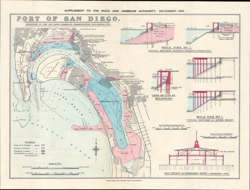
Port of San Diego. Supplement to the Dock and Harbour Authority, December 1938.
1938 (dated) 13.25 x 17.625 in (33.655 x 44.7675 cm) 1 : 60000
1938 (dated) 13.25 x 17.625 in (33.655 x 44.7675 cm) 1 : 60000
Description
This is a 1938 Ward and Foxlow map, nautical chart, and schematic drawing of the Port of San Diego, based on a map by engineer M. N. Donnan, that appeared as a supplement to the publication Dock and Harbour Authority.
Several military facilities, including a Naval Training Station, Marine Corps Base, Army Air Reserve Hangars, and a 'U.S. Destroyer Base' are marked; the large area noted as 'U.S. Government Property' on North Island was and remains a Naval Air Station. Lindbergh Field at top is the basis for today's San Diego International Airport; adjacent to the airport is an outpost of Consolidated Aircraft Corp., one of the main producers of flying boats at the time, and later of the B-24 Liberator bomber during the Second World War.
A Closer Look
The sheet is divided roughly in half, with the left half containing a map and nautical chart of the port and the right half consisting of schematics of bulkheads, mole piers, and the Broadway Pier (still in operation, though with a new passenger terminal built in 2010). The map highlights areas expected to be dredged or reclaimed, as well as dredging and reclamation work already underway. Soundings are marked throughout the bay, while on land, streets, neighborhoods, military bases, and other features are labeled.Several military facilities, including a Naval Training Station, Marine Corps Base, Army Air Reserve Hangars, and a 'U.S. Destroyer Base' are marked; the large area noted as 'U.S. Government Property' on North Island was and remains a Naval Air Station. Lindbergh Field at top is the basis for today's San Diego International Airport; adjacent to the airport is an outpost of Consolidated Aircraft Corp., one of the main producers of flying boats at the time, and later of the B-24 Liberator bomber during the Second World War.
Historical Context
As a natural deepwater harbor, San Diego Bay was recognized in the 19th century as an ideal site for a major port. However, several obstacles prevented this idea from becoming a reality, especially narrow channels leading to the bay that would prevent larger ships from approaching it. As a result, in the early 20th century, business and civic leaders began to consider means of dredging the channels and building modern port facilities, with an added impetus coming from the U.S. military, which similarly recognized the bay's potential. In 1919, the San Diego Harbor Commission and Harbor Department was established, and large-scale dredging and reclamation plans were formulated and enacted, with the most intensive work undertaken in the 1930s with the cooperation of the federal government, documented here. In subsequent years, the Second World War led to even greater infrastructural development, making San Diego a key center for several branches of the military in addition to commercial, fishing, and passenger ships.Publication History and Census
This map was originally drawn by engineer M. N. Donnan and was republished in 1938 along with the schematics as a supplement to the Dock and Harbour Authority, a trade journal published by Ward and Foxlow, located on Harcourt St. in Marylebone, London. The map is not independently cataloged in the holdings of any institution, though the University of California Los Angeles does catalog similar Dock and Harbour Authority supplement maps of various ports from the same time period. The entire publication is widely distributed in institutional collections, though the range of volumes held by individual libraries is difficult to determine from aggregated catalog listings.Cartographer
Ward and Foxlow (c. 1893 - 1993) was a London-based printer and publisher specializing in auction catalogs, trade journals, and technical publications. One particular area of focus was maritime trade and port facilties, most notably in their Dock and Harbour Authority, published between the early 1920s and 1980s. More by this mapmaker...
Condition
Good. Wear along original centerfold. Slight loss where previously bound into a volume with staples.