This item has been sold, but you can get on the Waitlist to be notified if another example becomes available, or purchase a digital scan.
1879 U.S. Coast Survey Map of Sandy Hook to Barnegat Inlet, New Jersey (Toms River)
SandyHookBarnegatInlet-uscs-1879$250.00

Title
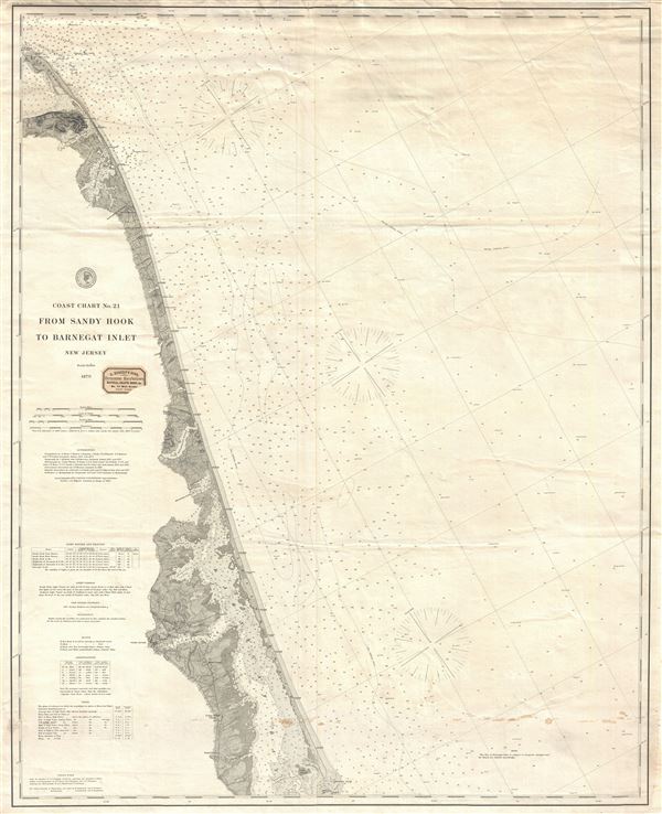
Coast Chart No. 21 From Sandy Hook to Barnegat Inlet New Jersey.
1879 (dated) 38 x 31 in (96.52 x 78.74 cm) 1 : 80000
1879 (dated) 38 x 31 in (96.52 x 78.74 cm) 1 : 80000
Description
An uncommon 1879 nautical chart or maritime map of the New Jersey coastline between Barnegat Inlet and Sandy Hook. The chart offers countless depth soundings and a wealth of practical information for the mariner as well as superb coastal detail. The map identifies the course of the Long Branch and Seashore Railroad as well as various seaside communities, including Long Branch, Deal, Asbury Park, Ocean Grove, Spring Lake, Seagirt, Squan Village, Lavallette City, Seaside Park, Toms River, Motts Corner, Cedar Creek Village and Forked River, among others. Issued in 1879 under the supervision of Charlile P. Patterson, Superintendent of the Coast and Geodetic Survey. Represents coast chart no. 21 or 121. Later issues of this map were presented as a series where, this being the upper of three sheets, however, this present example is an independent issue.
It is noteworthy that this is the heavy stock copperplate issue of this map, not one of the later economically mass produced electrotype issues. The original pressmark is visible all around the map. This map was originally sold by 'D. Eggert's Sons, Chronometers Manufacturers Nautical Charts, Books, and Co.' located at 74 Wall Street, New York. The remarkable D. Eggert pastedown is still present just under the title.
It is noteworthy that this is the heavy stock copperplate issue of this map, not one of the later economically mass produced electrotype issues. The original pressmark is visible all around the map. This map was originally sold by 'D. Eggert's Sons, Chronometers Manufacturers Nautical Charts, Books, and Co.' located at 74 Wall Street, New York. The remarkable D. Eggert pastedown is still present just under the title.
Cartographer
The Office of the Coast Survey (1807 - present) founded in 1807 by President Thomas Jefferson and Secretary of Commerce Albert Gallatin, is the oldest scientific organization in the U.S. Federal Government. Jefferson created the "Survey of the Coast," as it was then called, in response to a need for accurate navigational charts of the new nation's coasts and harbors. The spirit of the Coast Survey was defined by its first two superintendents. The first superintendent of the Coast Survey was Swiss immigrant and West Point mathematics professor Ferdinand Hassler. Under the direction of Hassler, from 1816 to 1843, the ideological and scientific foundations for the Coast Survey were established. These included using the most advanced techniques and most sophisticated equipment as well as an unstinting attention to detail. Hassler devised a labor intensive triangulation system whereby the entire coast was divided into a series of enormous triangles. These were in turn subdivided into smaller triangulation units that were then individually surveyed. Employing this exacting technique on such a massive scale had never before been attempted. Consequently, Hassler and the Coast Survey under him developed a reputation for uncompromising dedication to the principles of accuracy and excellence. Unfortunately, despite being a masterful surveyor, Hassler was abrasive and politically unpopular, twice losing congressional funding for the Coast Survey. Nonetheless, Hassler led the Coast Survey until his death in 1843, at which time Alexander Dallas Bache, a great-grandson of Benjamin Franklin, took the helm. Bache was fully dedicated to the principles established by Hassler, but proved more politically astute and successfully lobbied Congress to liberally fund the endeavor. Under the leadership of A. D. Bache, the Coast Survey completed its most important work. Moreover, during his long tenure with the Coast Survey, from 1843 to 1865, Bache was a steadfast advocate of American science and navigation and in fact founded the American Academy of Sciences. Bache was succeeded by Benjamin Pierce who ran the Survey from 1867 to 1874. Pierce was in turn succeeded by Carlile Pollock Patterson who was Superintendent from 1874 to 1881. In 1878, under Patterson's superintendence, the U.S. Coast Survey was reorganized as the U.S. Coast and Geodetic Survey (C & GS) to accommodate topographic as well as nautical surveys. Today the Coast Survey is part of the National Oceanic and Atmospheric Administration or NOAA as the National Geodetic Survey. More by this mapmaker...
Condition
Good. Some creasing and soiling, else clean. Original seller's paper stamp appears near title area.
References
Stanford University, Branner Earth Sciences Library, G3811 .P5 1892 .U4 SHEET1.