
This item below is out of stock, but another example (left) is available. To view the available item, click "Details."
Details
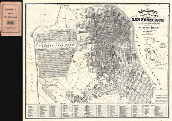
1891 Bancroft Pocket Map of San Francisco, California
1891 (dated) $1,250.00
1887 Bancroft Pocket Map of San Francisco, California
SanFrancisco-bancroft-1887$1,100.00

Title
Bancroft's Official Guide Map of City and County of San Francisco, Compiled from Official Maps in Surveyor's Office.
1887 (dated) 25.5 x 30.5 in (64.77 x 77.47 cm) 1 : 30000
1887 (dated) 25.5 x 30.5 in (64.77 x 77.47 cm) 1 : 30000
Description
A stunning 1887 example of Bancroft's important pocket map of San Francisco, California. This map covers the northern top of the San Francisco Peninsula rom the Pacific Ocean to San Francisco Bay and as far south as Rancho Canada de Guadeloupe. Bancroft employs shading to indicate developed and undeveloped blocks. At the bottom of the map there is a numerical key wherein some 376 individual buildings are located and categorized. Concentric circles on the map indicate half-mile distances from the ferries. Development extends as far as the race track. Rancho Laguna de la Merced, San Miguel Rancho, and Rancho Cañada de Guadalupe Rodeo Viejo y Vistación are at this point undeveloped. An inset map in the right details the greater San Francisco Bay area.
This map was first published in 1871 and enjoyed an immediate popularity. Revised editions appeared in 1873, 1877, 1881, 1882, 1883, 1887 (present copy), and 1891. In 1973 two editions were issued with the latter of these two exhibiting a vast expansion of the map to include growth in the western part of the peninsula including Golden Gate Park and the surrounding lots. Some editions feature a light blue outline of the landfill in eastern San Francisco, but this was omitted from the 1887 edition. Sally Woodbridge speculates that 'it was not part of the original base map but was added because of special interest at the time.'
Today all examples of Bancroft's San Francisco are highly desirable as the finest map of San Francisco available during that city's most expansive period of development.
Cartographer
Bancroft Company (1852 – present) was a San Francisco, California, based publishing firm active in the second half of the 19th century. Bancroft is considered the first major publisher to develop in California. The firm was founded in 1852 when Herbert Howe Bancroft (1832 – 1918) relocated from Buffalo, New York, to San Francisco, California, with a stock of books to establish a regional office of his family's East Coast publishing house. The firm, initially situated in the Naglee Buildings and Montgomery and Merchant Streets, was immensely successful both as booksellers and publishers. H. H. Bancroft resigned from the company in 1868 to pursue historical study and passed on management to his brother, Albert Little Bancroft (1841 – 1914). A. L. Bancroft ran the firm from 1869 and 1871. It was Albert who published the firm's first maps, including general maps of California, pocket maps of San Francisco, and other southwest focused material. Albert led the firm during its most expansive period, was a pillar of the San Francisco community, and a founding member of the Bohemian Club. The firm was exceptionally clever in leveraging California's gold wealth to maximize its profitability. According to A. L. Bancroft,
A purchase of an item costing $1.00 in currency in New York could be sold for $2.00 in gold in San Francisco. With the $2.00 in gold the company bought New York exchange currency at 250% and received $5.00 for what had originally cost $1.00. (Clark, H., A Venture in History, p. 9)Meanwhile his brother, H. H. Bancroft dedicated himself to history and writing. He established the 'History Factory,' a commercially organized production house for historical research. Bancroft planned to write an expansive 39 volume history of the western part of North America. Only parts of Bancroft's were published due to an 1886 fire at Bancroft and Company where in several unpublished volumes were destroyed. Throughout his long career Bancroft compiled a vast library of some 60,000 volumes, most related to the western United States in one way or another. This vast collection was eventually transferred to the Bancroft Library at the University of California, Berkeley. In 1895 The educational stock of the Bancroft company was sold to Whitaker and Ray. In time the publishing arm of the Bancroft Company relocated to New York City where it took on new partners and focused on legal publications under the imprint Bancroft-Whitney Company. In 1989 it was absorbed into the International Thomson Organization. More by this mapmaker...
Condition
Very good. Professionally flattened and backed on archival tissue. Accompanied by original binder.
References
Rumsey 2742.000 (1891 edition), 3371.002 (1887 edition). Phillips (Maps) p.777. Huntington Library 15238 (1889). Woodbridge, S., San Francisco in Maps and Views, page 80-81. Boston Public Library, Leventhal Center, G4364.S5 1873 .A422, G4364.S5 1873 .A42, G4364.S5 1877 .A42, G4364.S5 1881 .A42. Clark, H., A Venture in History, p. 9