This item has been sold, but you can get on the Waitlist to be notified if another example becomes available, or purchase a digital scan.
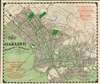
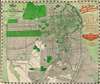
1906 Candrian City Plan or Map of San Francisco, Oakland, and Berkeley, California
SanFrancisco-candrian-1906-2$275.00


Title
Map of Oakland Alameda and Berkeley. / Map of the City and County of San Francisco.
1906 (dated) 15.25 x 18.25 in (38.735 x 46.355 cm) 1 : 29000
1906 (dated) 15.25 x 18.25 in (38.735 x 46.355 cm) 1 : 29000
Description
This is a 1906 Hermon Candrian city maps or plans of Oakland / Berkeley and San Francisco, California, published shortly after the disasterous 1906 San Francisco Earthquake. Depicting Berkeley, Oakland, and Alameda on one side and San Francisco on the other, green lines trace streetcar routes in all four cities. Green also highlights the University of California Berkeley, the Deaf, Dumb, and Blind Asylum, and the St. Mary's, Jewish, and Mountain View Cemeteries. The Key Route, the Southern Pacific mainline, and the Coast Line narrow gauge all cross San Francisco Bay west toward San Francisco. An advertisement for Theodore Gier Wine Company of Oakland appears in the lower-left corner. At the same time, an ad for William Knapp and Company, an importer and manufacturer's agent, occupies the upper right. In San Francisco, the Presidio Reservation, Golden Gate Park, the Alms House, and numerous parks, squares, and cemeteries are also shaded green. An advertisement for the Sutter Home Wine and Distilling Company, which still exists today, is situated in the upper right corner.
San Francisco and the 1906 Earthquake
However, the detail most of interest here is the thick green line outlining the 'Fire District' in downtown San Francisco. The 1906 San Francisco Earthquake struck on the morning of April 18. The fire soon broke out in the city and raged for several days. In the end, over eighty percent of the city was destroyed by either the earthquake or the fire, and over 3,000 people lost their lives. Estimates state that the subsequent fires caused ninety percent of all the destruction wrought by the disaster. Over thirty fires raged throughout the city over the following four days, destroying nearly 25,000 buildings and 490 city blocks. It remains the deadliest event in California's history and ranks among the worst natural disasters in American history.Publication History and Census
This map was created and published by Hermon Candrian in 1906. Four examples are cataloged in OCLC and are part of the institutional collection at the California Historical Society, the Lawrence Berkeley National Laboratory, the Institute of Governmental Studies at the University of California Berkeley, and the University of California Berkeley Libraries.Cartographer
Hermon Anton Candrian (March 28, 1852 - November 28, 1928), commonly publishing as H. A. Candrian, was a Swiss-American map publisher active in San Francisco in the first half of the 20th Century. Candrian was born in Bonaduz, Graubünden, Switzerland. It is unclear when he emigrated to the United States, but he working as an insurance agent in Seattle around 1900 and by 1905 had relocated to San Francisco. From at least 1906, his wife, Bertha Wilhemina Candrian (née Harry; 1862 - 1944), drafted many of his maps. Candrian’s works focus heavily and tourist and railway guides to the city of San Francisco and the general Bay Area. More by this mapmaker...
Condition
Very good. Maps printed on both sides of sheet. Exhibits small repair on Oakland/Berkeley side that overlaps the cigar advertisement in the upper right corner.
References
OCLC 80380557.